Oxford University Cave ClubCave Research Group publication 141961 Oxford University Expedition to Northern Spain |
1961 Expedition Report (CRG 14) |
The provision of caving equipment for a speleological expedition must naturally be a matter for careful study and organisation. A compromise will in general have to be made between the maximum possible amount of equipment which could conceivably be required in the field and the available finance. The limited budget of the 1961 expedition and the extreme generosity of firms finally combined to produce enough materials to make 1500 feet of electron ladder, nylon ropes for lifelining, wire belays; and, for each member of the expedition, overalls, helmets, boots, lamps and batteries, carbide lamps and carbide and waterproof electric torches. Plane tables and other surveying equipment were kindly loaned by the Oxford University Department of Surveying and Geodesy, and an Autoset Level by Hilger and Watts Ltd. About ten pounds weight each of Fluorescein and Rhodamine B were obtained for water tracing. The chemical and geophysical equipment is described elsewhere in this report. Besides the above-mentioned and more obvious items there are many ancillary items of equipment for which the caving organiser must make provision. Among these are a generator for the recharging of batteries, caving rations, first aid equipment, and pens, pencils, paper, inks, drawing board and tee square for the plotting of surveys.
The exploration of caves and potholes in the area was generally undertaken by groups of four or five members of the expedition, and it was ensured that one or more members of the expedition were always in the vicinity of the refuge to guard the equipment and keep a check on the weather conditions. These members would generally be on cooking duty for the day, and frequently helped with surface life-lining at a pre-arranged time, also bringing hot soup or beverages for the explorers to enjoy. Surface survey and geomorphological work was generally undertaken by mobile parties of two, who often camped overnight in the mountains.
Cave survey was undertaken to Cave Research Group Grade 4 if possible, but the remoteness of some caves sometimes led to surveys of only Grade 2 standard. Surface surveys and water tracing were carried out to correlate the surface and underground features.
Experiments were made with a beam made of Dexion steel angle in the rigging of ladders for the descent of open shafts.
Three large cave systems were explored, Pozo Palomeru (P1), Cueva del Viento (C15), and Cueva de Orandi (P14).
Pozo Palomeru (P1) is entered by a shaft of 43 metres which gives access to about a mile of passages, generally of vadose characteristics, and appears to be the result of the joining of at least three separate stream passages; the Candy Cavern series, ending in the sump near the entrance shaft, the main Collander Cavern - Blue Pool Passage series, and the Far Series (see Figure 2 and Figure 3). The often abrupt changes in level of the main passage seem to indicate a complex history. At the time of exploration only a few pools were seen in the main passage, but water marks and flood debris indicated that a powerful stream must flow through this system in winter conditions, and when the snow melts on the surface. The system has several instances of high-level oxbow passages, and at least two natural bridges consisting of flakes of rock across the passage (Plate VII). An interesting feature was a swirl bank of gravel in the chamber at the foot of the 6 metre pitch which opens from the entrance pitch. The stream which formed this must sink in the eastern corner of the chamber and may be connected with the sump to the southwest of the entrance pitch. Among the gravel were found several teeth of large herbivores (probably cows) and a few canine teeth (probably wolf).
Cueva del Viento (C15) was so named from the strong air current in the constricted entrance crawl. This cave consists of a series of rift chambers and stream passages leading to a large chamber with roof series and two main radiating passages (see Figure 4). The major of these is a rift passage with fine flowstone, stalagmites and rimstone pools, and is obviously an overflow passage for the large stream which rises from a sump and shortly sinks into an impassable rift at the inner limit of exploration. The way on here would appear to be by diving the sump or blasting the small tube above. It is possible that the active stream nearer the entrance to the cave might be joined by descending the rift in the further reaches of the rift passage. Midway along the passage there is evidence of phreatic features, a low chamber connecting with quite a complex network of passages, but the main features of the rift passage indicate vadose formation. The second passage radiating from the main chamber, Muddy Passage, has two entrance branches, both scalloped and indicating flow towards the main chamber. At the junction of these two branches are a boulder-filled chamber and another muddy chamber, on different levels and connected by a scalloped passage which opens onto a ledge in the wall of the first chamber. A crawl leads beneath the second chamber to a meandering rift connecting with a north-south passage. To the north the passage slopes upwards with a floor of calcite concretions covered with mud, and to the south via an interesting 'double passage' to a more constricted section with formations and a low, loose crawl into a boulder chamber, where an air current issues from a narrow rift. The 'double passage' consists of a rounded tube-like passage running immediately above a more angular and roomy passage. The air current is towards the main chamber in all parts of Muddy Passage; the predominant angle of dip is 40 to the east, a similar value to that found in the northwestern part of the above-mentioned rift passage. In the southeastern part of the rift passage, however, the dip is to the west, and this change of dip over a comparatively short distance has yet to be explained. Cueva del Viento possibly offers more opportunities for further exploration than any other cave visited.
Cueva de Orandi (P14) is the source of the water emerging at the Shrine of Our Lady of Covadonga. The entrance is a large arch in the cliff wall of the high-level valley of Collado de Orandi, and the resurgence is some 200 metres lower down the mountainside. The expedition explored the pothole to a depth of 75 metres, under very wet conditions. Further exploration will need an extensive amount of tackle, including a dinghy for crossing the lakes which occur at the foot of some pitches, and all tackle must be carried up a very steep mountain track, an ascent of 200 metres from the only road suitable for vehicles (see Figure 5).
Of the potholes of moderate size, four are worthy of special mention.
P9 (Figure 6) has two large open pots connected by a natural bridge. A boulder slope leads to a meandering passage of almost constant rate of descent and of progressively restricted proportions until it is finally blocked with mud and calcite-coated gravel, the whole being analogous to a funnel, as may be seen from the projected elevation of the pothole. Two features of note are a roof boulder jam consisting of a large carrot shaped boulder and several smaller ones, and a false floor in the form of an arch of calcite-cemented pebbles. A window at the foot of the shafts leads to a small rift chamber with strong air currents.
P10, situated near the southern rim of the polje Vega de Comeya, has an entrance consisting of an enlarged joint (see Figure 7) and continues to a chamber with roof pendants and a rock pillar still joining the floor and roof in one place. Open pots descend from the clint surface above. A crawl enters a rapidly descending passage which leads to an 8 metre pot, blocked at the bottom. The general direction is towards a cave in the south wall of the Vega de Comeya, C13, and a natural arch.
P11, near P10, has very little horizontal development Some 50 metres deep, it descends rapidly towards the floor of the Vega de Comeya. The entrance passages have a roof indicating a dip of 60°, which would explain the general development of the pot along this trend. Some fine rimstone pools occur where the passage begins a more rapid descent to a vadose passage. The deepest sections show down-cutting of the streamway from a bedding plane. The way on may be possible, but will need explosives or hammering. The entrances to this pothole are three in number, two open shafts and a third which may be entered by a rapidly descending grass slope and earthy gully.
C16, Cave of the Snow, situated about 1900 metres above sea level, was so called because the main chamber, some 30 metres across, was filled to a depth of about ten metres with many years' accumulation of snow, indicated by the bands of ice which also occur. The further reaches of the cave contain a loose scree. The snow has melt depressions of generally conical shape, and the whole is lit by the light from a ten metre shaft. Entrance may also be gained by a small passage with holes in the floor (see Figure 8).
A large number of smaller caves were explored and surveyed. These varied from about 50 metres in length to only a few metres. The small caves seem to be older than the large ones, and most of their formations were in decay, soft and covered with bergmilch. Cows often use them for shelter, and the shepherds use them for storing cheese.
At high altitudes many potholes were seen, some blocked by frost-shattered rock, but others open shafts, and quite deep. Some of these have been explored by expeditions in 1962 and 1963, but many remain as an attraction for further work in the area.
The hill of La Porra de Enol behind the refugio has some interesting features. Small potholes occur near the top of the hill in clint surfaces: P2 is a series of connected rift chambers, and P3 a small vadose cave now almost blocked by formations (see Figure 9). A controversial feature is a vertical stream course, dry at the time of the expedition, and called by the natives a 'fire break'. The course begins at a pocket of sandstone near the top of the hill. Such pockets of sandstone occur along with shale to a small extent in the predominantly limestone terrain. The graded fan of gravel at the foot of the course shows that it has at some time carried a stream. This probably happens only in wet weather, when the sandstone may act as a reservoir rock (Plate I).
Another controversial feature occurs at a height of about 1950 metres above sea level: the Campo de los Pozos (see Figure 1). This is an almost circular solution hollow, the floor of which is pitted by innumerable shake holes. This hollow, dry at the time of the expedition, may at some time have held a lake which drained into the shakeholes, or may even be in a waterlogged state in very wet weather. A more likely suggestion is, however, that the hollow is full of snow in wintertime, and drains through the shakeholes when it melts every spring.
A number of blocked entrances, fissures, shakeholes, etc., were catalogued by the expedition as B1, B2 etc. and in all cases these features were so designated when not considered worthy of classification as caves. Many, however, have excellent prospects as digs.
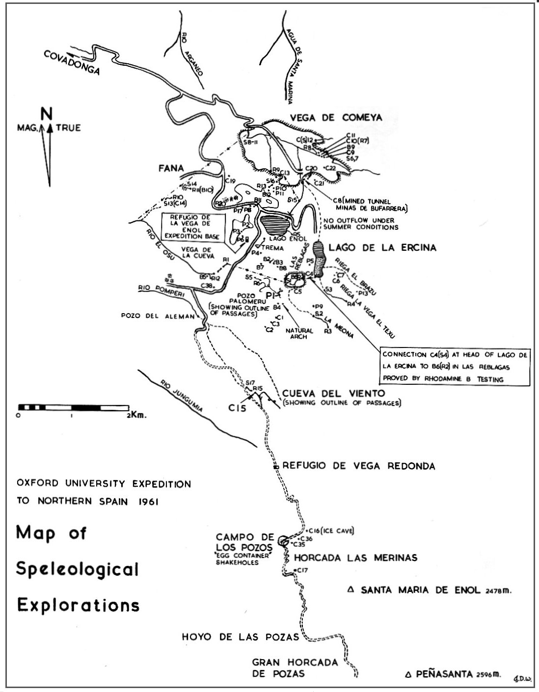
A full catalogue of the potholes, caves and blocked entrances studied by the expedition is given in Tables 5 - 7, and these should be studied in conjunction with Figure 1. The designation P for pothole is particularly appropriate as the Spanish word Pozo has the same initial letter, as is also the case for the designation C for cave or (Spanish) cueva. The system of classification is to be continued by the 1963 Oxford-Derbyshire Expedition.
It is hoped that his description of a most fascinating area will inspire others to attempt further exploration there in the near future.
J.D. Wilcock, Kidsgrove, July 1964.
| P1 | Pozo Palomeru 43 metres entrance shaft, walled at top, leads to extensive passages. For full description see text and Figures 2 & 3. |
| P2 | 20 metres entrance shaft in clint surface leads to a series of connected rift chambers with interesting formations. Situated on the hill of La Porra de Enol, above the refugio (see Figure 9). |
| P3 | Situated on the hill of La Porra de Enol, above the refugio. 8 metres shaft in clint surface enters a chamber and a small vadose passage, length 20 metres, with crystal formations on floor and walls and several large columns. Extremities blocked by flowstone (see Figure 9). |
| P4 | Situated in clint surface opposite the refugio, at the beginning of La Vega del Bricial. 8 metre rift, probably enlarged grike. |
| P5 | In cliff east of the polje Las Reblagas. Small vertical and horizontal extension: blocked by bergmilch formations. |
| P6 | On the hill La Porra de Enol, above the refugio. 2 metre climb down to water-worn passage and spherical chamber. |
| P7 | In cliff on west side of Lago de la Ercina. 11 metre rift, blocked with boulders. |
| P8 | Near Fuente Seca, in cliff face to south of Covadonga - Enol road. Rift which narrows at 13 metres depth. Window leads to chamber with stream gully and sink hole (see Figure 10). |
| P9 | Situated on the hillside La Joyosa between the valleys of La Meona and Riega la Vega el Texu. Depth 55 metres. For full description see text and Figure 6. |
| P10 | Situated in bowl-shaped valley above the southern cliffs of the polje Vega de Comeya. Depth 21 metres. For description see text and Figure 7. |
| P11 | Near P10. Very little horizontal development. Depth 51 metres. For description see text and Figure 1. |
| P12 | Situated in valley bottom to the northeast of La Rasa. Three shafts; 10 metres, with flat boulder floor; 20 metres, overhang with flat boulder floor (marked by small tree); 5 metres, square section with choked boulder floor. |
| P13 | Situated above Riega el Brazu. 6 metre climb down in shakehole leads to small passages and chamber (see Figure 6). |
| P14 | Cueva de Orandi. Large entrance in northern cliff wall of the high-level valley Collado de Orandi. Explored to 75 metres depth by OUENS61. Resurgence at the shrine of Our Lady of Covadonga some 125 metres lower than this. For description see text and Figure 5. |
| The discoveries of the 1962
expedition are described in the text "A return to the Picos". The following are a few of the potholes visited: |
|
| P17 | In shakehole south of Covadonga-Enol road, west of P8. Depth 80 metres. |
| P20 | In shakehole north of Covadonga - Enol road, 30 metres west of the 10 Km stone. 6 metre climb down through boulders leads to scalloped passage and chamber filled with boulders, which may be penetrated a further short distance. |
| C1 | On slopes of El Diadiellu on the north side of the northernmost of two limestone ridges, at the bottom of a small cliff. Crawl down to two chambers with side passages. |
| C2 | In the northern cliff of Diadiellu. Climb down to chamber and two passages. Decayed cave with slime. |
| C3 | On slopes of El Diadiellu in the southern limestone ridge. About 15 metres long, finely sculptured. |
| C4 | At southwest corner of Lago de la Ercina, blocked with concrete dam constructed to prevent overflow via this cave and to maintain the lake level to provide a water supply for the Minas de Buffarera. Fissure cave with deep pool. The present sink is a few metres from the cave in the lakebed, and the resurgence in the polje Las Reblagas (proved by dye testing). |
| C5 | Cueva de la Cascada Seca. In the southern cliff face of the polje Las Reblagas, immediately below the dry valley of La Meona. Probably formed by spray from the waterfall or solution from the streambed directly above. Dry stream course continues on the polje floor to join the active stream course between B6 and S1. |
| C6 | Small cave in the face of the cliff above the southwestern corner of Lago de la Ercina. |
| C7 | Near C6, a few metres to the north. Large entrance with extension for about 10 metres. Probably associated with the eroded water level visible on this cliff face (glacial lake level?). |
| C8 | In the gorge of the stream flowing out of Lago de Enol in the south cliff of the Vega de Comeya. Large entrance. No extension, but used as start to artificial tunnel through the hillside to the gorge, associated with the Minas de Buffarera. |
| C9 | In southeastern part of the Vega de Comeya. Former cave of debouchure leading into the dry valley immediately above R7. Entrance chamber has floor covered with faeces, and leads to a constricted roof passage. |
| C10 | In southeastern part of Vega de Comeya. Cueva de la Fuente de Comeya. Cave of debouchure. Low boulder-filled chambers. Stream rises from sump (R7). |
| C11 | Near C10, around the bluff to the north. Large fissure entrance changing to stream passage. Used for cheese storage, and as a cow shelter. Formations covered with bergrmilch, and in an advanced state of decay. |
| C12 | Small stream running due west sinks inside large cave mouth on the slopes of Cuelo Salgaredo. Large chamber and two small stream passages, which are finally blocked. |
| C13 | Large entrance plus three smaller entrances near the natural arch in the southern cliff face of the Vega de Comeya. |
| C14 | Group of caves near a small sink (S13) in the dry valley above the Rio el Osu, which is the western extension of the Vega de Seon. |
| C15 | Cueva del Viento. At the head of the Canal de Canraso, a dry valley north of the refugio of Vega Redonda. For full description see text and Figure 4. |
| C16 | Cave of the Snow. Meandering stream passage leads to chamber with snow. For full description see text and Figure 8. |
| C17 | Rift cave in cliff by track below Cuesta de Cebolleda. 15 metre long, narrow fissure, ending in small aven. Pure white walls at entrance. |
| C18 | Large cave frequented by cows, situated at the side of a small valley Vega las Fuentes. 20 metre wide entrance with 20 metre extension behind. Shelf with large calcite crystals. |
| C19 | Situated between Vega de Comeya and the Enol road, under a small cliff. Tunnel-like passage leads to chamber with flowstone. |
| C20 | At head of gorge from Lago de Enol, above Vega de Comeya. Single chamber, with remains of gravel/clay floor 2 metres above floor level. |
| C21 | Large entrance, leading to tunnel-like cavern 10 metres high and 30 metres long. Of notably rounded section, containing blocks of crystalline calcite and stumpy, decaying stalactites at the inner end. Earth floor with vegetation. South side of Vega de Comeya. |
| C22 | South side of Vega de Comeya. Meandering stream passage, rising roughly 20° angle from entrance. Lower meander course of passage cuts under the side of the main (upper) passage. Length 10 metres. |
| The following are a few caves visited by the 1962 expedition: | |
| C35 | Rift cave on Porru Bolu, near Campo de los Pozos. Entrance with bank of snow leads to 20 metre-high chamber with boulder floor. Boulder slope finally ends in choke with strong air current. Length 60 metres. |
| C36 | Prominent opening facing north in side of Porru Bolu. Length 10 metres, no features of note. |
| C38 | On north side of track from Lago de Enol to the bridge over the Rio Pomperi. Entrance through boulders in clint surface above the Vega de la Cueva. Length 13 metres. Climb down 3 metres leads to a boulder passage and a chamber with many beautiful rimstone pools and a sump. A low passage connects with a passage parallel with the first and with pools. A tight rift runs from this chamber to the north. Thought to be part of a series of sinks and risings at the head of the Rio el Osu. Water from C38 probably rises at R12. |
| B1 | On the hillside of La Porra de Enol behind the refugio. Above P2, opening out of large shakehole with natural arch. An open shaft choked with mud and faeces. |
| B2 | In Vega del Bridal, near small sink. Small pot blocked with boulders. |
| B3 | In Vega del Bricial, 100 metres east of B2. Small pot blocked with boulders which takes a small stream (pH 8.1). |
| B4 | Cow Cave. At top of spur overlooking Las Reblagas. Large arch where cows shelter. |
| B5 | On left bank of gorge of Vega de la Cueva near the stream. Two entrances blocked by sheep dung, and sheep sheltering. |
| B6 | Las Reblagas resurgence. In the polje Las Reblagas, below the northeastern bluff. Blocked cave from which emerges a strong stream, proved to be that from the Ercina sink (S4). pH 7.2. Duration of test 29 hours between sink and resurgence. Boulder choke prevents entry. |
| B7 | Shakehole in the Vega del Bricial, blocked with boulders. |
| B8 | Hole in rock face at end of dry streambed near B3. |
| B9 | In southeastern part of the Vega de Comeya, between C9 and C10. Used as cow shelter. 6 metre crawl with rimstone pools, very tight. |
| B10 | At rising R11 (Fuente de Abesedo). Small stream passage, too tight to enter. |
| B11 | Rift in shakehole bottom near P8, a few metres to the east. |
| B12 | Shakehole with tree near P10, P11, above the southern cliffs of the Vega de Comeya. |
Several of the above appear to be promising digs. In addition the 1962 expedition reports a dig with air current just to the south of the track through the Vega del Bricial near P1. 3 metre climb down through boulder choke leads to crawl blocked with stalagmite boss. This may provide an alternative entrance to P1, the survey of which proves it to be near the surface, particularly in its further reaches (see Figure 3).
The system of classification by numerals in the Picos area given in Tables 3 - 7 is to be continued for the discoveries of the Oxford-Derbyshire Speleological Expedition to North-West Spain 1963, to be published in early 1965.
Since there is no equivalent of the British National Grid in Spain, and maps are generally much inferior to the standard available in Britain, the locations of features classified in Tables 3 - 7 are necessarily vague. An attempt has been made to describe the features in such a way that they will be recognisable to subsequent expeditions, however, and Figure 1 is intended to give the best possible guide to the positions of features classified by OUENS61.