Oxford University Cave ClubReport of the Oxford University Cave Club Expedition to Northern Spain, 1972Republished with minor amendments and updates by Speleogroup from Westminster Speleological Group Bulletin Nov/Dec, 1972, Speleogroup Expeditions to Northern Spain 1975/76 |
OUCC Home Page
|
G.C.Cox, Organizer
N.J.Hancock, Geologist
J. Davies
A.G. Brooks
Angel Benito, Guest Member
The main aim of the expedition was to spend three weeks investigating and evaluating the area to the west of the Sierra de Cuera (site of our last three expeditions), since it seemed a potentially interesting region for a large expedition planned for 1975. The region concerned, part of the coastal range, is bounded by the Rio de las Cabras on the east, the Rio Sella on the west, the Rio Gueña on the south and the coastal plain on the north.
We camped the first and last weeks at El Mazuco, from where we visited the northern and eastern parts of the area. The week in between we spent near Cangas de Onis, partly at Lake Enol, in the High Picos, partly in the hamlet of Las Rozas, between Cangas and Arredondo. From here we investigated the southwest part of the region, which obligingly fitted our timetable by proving less interesting.
Our work in the region consisted of trogging, caving and preparing a geological map. We also revisited several of the El Mazuco caves, but without making any startling new discoveries. For the third week we were joined by a young Spanish caver, Angel Benito, from Madrid. He found the British (OUCC) way of caving a bit of a shock, but soon adapted and was converted.
As well as caves within the area described above, we also revisited Cueva Orandi, above Cangas on the edge of the Picos. This had been partially explored, but not bottomed, by the 1961 Oxford expedition, and we felt a revisit was long overdue. We are now convinced that a big push is even more overdue. Results from the coastward part of the range were also extremely promising, and organization of the big expedition for 1973 is now well under way. Proc OUCC 7.
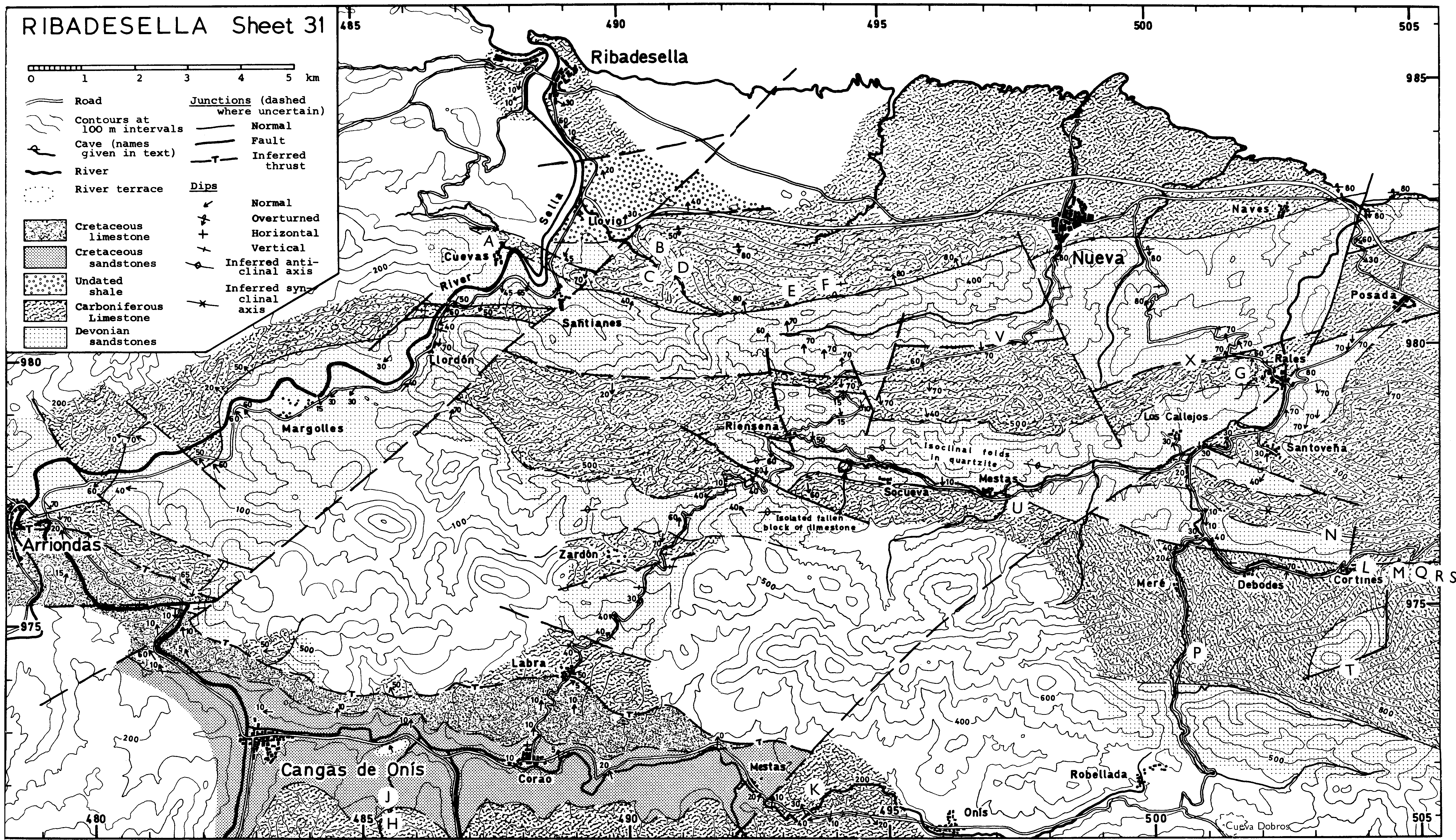
Throughout the report, grid references and spot heights are taken from the 1:50,000 Edición Militar maps (sheet 31 for all except Cueva Orandi). The newer maps, so far only available at 1:200,000 scale for this region, have a different grid system. All cave lengths quoted are estimates.
During the last few years we have had plenty of opportunity to become familiar with the road from El Mazuco to the beach, it is surprising therefore, that the obvious depression above Rales was only noticed this year. After driving to Rales, we followed our usual practice of first of all explaining our presence and intentions to the locals. This important aspect of expedition work is achieved by visiting the bar and taking some refreshment. Thirst and etiquette satisfied, we moved on to inspect the resurgence just behind the village. Here Guy performed his celebrated impression of M. Casteret. the well-known naked French caver but without finding a way in.
A short walk up the hill and down again into the depression behind, and a sizable cave entrance came into view. A trickle of water was sinking some way further up-valley, but the main entrance was dry. As dry as could be expected, that is, in view of the herd of cows stabled in the cave.
We were a little short of equipment on this trip, having only one carbide lamp and no helmets between the four of us. At the first 'obstacle', a knee-deep pool, three of us therefore waited in the dark while Jon explored alone. He returned some time later with tales of a complex system with a fine streamway, most of the development being upstream.. This came as a surprise, since we were only expecting a small system leading down towards the Rales resurgence which was only perhaps 200m away in a straight line. The inescapable conclusion is that the cave runs in under the limestone ridge and drains it longitudinally.
Jon and I returned to Rales some time later, after a spur-of-the- moment decision one evening to go caving. We changed at El Mazuco, drove to Rales in caving kit (cow-eaten trousers and battledress blouse for Jon, while I favoured shorts and cagoule) and amazed the villagers by donning helmets and lights and marching up to the cave. We confirmed Jon's findings, pushing upstream to a 5-metre cascade which is a maypole job. The stream passage is very handsome, clean and looks typical of a long percolation water type resurgence. Part of the cave has recently been explored by a Spanish group but they seem to have been no further than us. This is a must for next year
Grid Reference: 5020 9795 Altitude 50m. Explored length: 500m,
A small patch of limestone occurs behind the village of Socueva (see map). This outcrops in the form of an impressive cliff behind the village, with a small, impenetrable resurgence at the Rot of 31. The resurgence is piped, and so small is it that a cork is inserted in the pipe when water is not being taken, to conserve supplies!
In the cliff are several cave entrances, some of which are said by the villagers to lead to caves. In view of the small area of limestone, though, and the fact that it receives little drainage from insoluble rocks, the caves are not likely to be extensive.
Socueva resurgence Grid reference 4950 9774 Altitude: 270m.
The arroyo de Llovio sinks in a deep blind valley, runs underground for 500m as the crow flies, dropping 85m on the way, and resurges at the Cueva de Tinganón. This much we deduced from the map, so we parked the car as far up the hillside as we could get it and set off up the rather trackless and steep sided valley to the resurgence. (Editor's note: There is an adequate track following the stream to the resurgence). We each picked different routes, at different altitudes, but by the time we met up, a few bends of the gorge before the cave, we had all had sufficient glimpses to realise that something very impressive was in store. Climbing a series of short cascades, we rounded the last bend and were confronted with an unbelievable sight, a 60m tall archway, almost as wide as it was high. The good-sized stream seemed lost, and wandered about among cottage-sized blocks on the floor.
On this first trip, we stopped at a cascade only some 200m inside as we were in ordinary kit. Unfortunately, at this stage we developed the notion that there would be a big pitch in the cave, so on our next trip we decided to walk to the top entrance of Tinganón. This is a very long way by the only path, and then involved a steep descent - needing ladders - down the surface streamway. We were confronted by an entrance as vast as the downstream one. Following the stream down, we soon found ourselves at the point at which we had stopped previously. The big pitch did not exist - in spite of the precipitous surface streamway, the cave descends in a series of slopes and small steps. Throughout, the roof height is maintained at 50m or more. For much of the way, the width is similar. In a couple of places, the streamway narrows to a vadose trench only 1-2m wide. A long way above, though, the passage can be seen at its original width. Presumably the 'big pitch' did once exist, but vadose down cutting has removed it.
The cave consists simply of a main stream passage. There is one short choked tributary, and an oxbow near the upper entrance. Total length is about 700m. Formations throughout are on a similar scale - though it is often necessary to climb up well above floor level to see them. The cave is well known locally, but few people go into it, though it has been explored. It would make an incredible show cave - or (heaven forbid) route for a 3-lane motorway! A dam, now disused, has been built inside the entrance - perhaps for water supply, as the stream is now dammed for that purpose further downstream. In the polje above, several dry entrances may well merit investigation.
WWW Editor's note. The best way to approach Tinganón is simply to follow the stream up from the farm buildings below. There is a path which leads to the lower entrance in about 30 minutes. A trip trough Tinganón is probably the fastest way to reach Cueva Negra, but care should be taken climbing out of the upper entrance as the rock is slippery.
Resurgence - grid reference: 4906 9816 Altitude: 160m Sink - grid reference: 4911 9815 Altitude: 246m Length 700m, Depth 85m (from map)
The track from the new main coast road up to the Cueva de Tinganón is, to say the least, indistinct. Thus it was that on our first visit to the cave, each member of the party chose his own route, according to personal preferences for overgrown streamway, exposed and crumbling traverses, or chest-high gorse. Jon's rocky route proved the slowest but the most interesting, for he stumbled across an unsuspected gully with a respectable stream issuing. Since the vegetation was not strong enough for a Tarzan-type descent, and approach from below involved overgrown and slippery cascades, the cave was left for another time.
A few days later Jon and I returned, armed with 10m of ladder to reach the cave entrance from above. An artistic eye hole belay allowed the ladder to hang free from the first rung to the last, which was a foot or so off the floor.
Upstream, the passage was high and, promising and, we hoped, unexplored. "At least this one won't be full of old water works", I remarked, casually tripping over two pipes and a dam. Damn! The purpose of these works is not clear, since the pipes lead only from the dam to the entrance, where there is no sign of any tank or reservoir.
Above the dam, the stream emerged from a sump, while a drier route continued to the right. Several waistdeep pools were passed until we finally halted at a slightly deeper one, where efforts at a highlevel traverse were unsuccessful. On cur return, we noticed another high level passage running off above the dam, but we were not inclined to visit it. Holds cut in the slope below indicate that it has been explored before.
Although we only explored two or three hundred metres of cave, this is apparently a very important site. It seems to be the only sizable resurgence draining this large mountain, and it is likely that the stream is fed by Cueva Negra and even more remote sites. Prospects look good for 1973.
Grid reference: 4906 9818 Altitude: 220m Length explored: 2-300m.
See also: Proc OUCC 7 and
[ Note by Martin Laverty 2004: rediscovered by Grupu Gorfoli and resurveyed by a Portuguese group - as reported in the Asturian Caving site. It is now known as Cueva Pixuacu, but they also retain Abseil Cave: http://www.espeleoastur.as/esploraciones/pixuacu/pixuacu.htm]
The seaward ridge of the coast range has a limestone scarp running steeply down from a ridge (maximum altitude 700m) to a limestone plain of altitude 90m or less. A resurgence, the Madre del Rio, is marked on the map; in fact, this resurgence is very small, but innumerable karstic holes in the plain lead to a level of inundation some 3m down, so that it is well-nigh impossible to estimate the true flow.
Behind the ridge is a closed depression, the southern side of which is sandstone. This is very remote from the road, so we only paid it one visit, in spite of the enticing words Cueva Negra and Cueva de Lledales on the map. Cave entrances abound in the valley, which in fact consists of a chain of depressions. Most of them take water only in flood, if at all. At the point where the map marks Cueva de Lledales is indeed a cave entrance taking a small stream in all but the driest conditions. A large entrance leads to a walking-size passage, with occasional obstructions. This meanders very tortuously for about 100m, then suddenly stops, the water sinking down a crack a few centimetres wide. Fortunately, our disappointment was ended soon after by the discovery of Cueva Negra.
Cueva de Lledales, Grid reference: 4941 9008 Altitude: 581m, Length: 100m.
Madre del Rio Grid reference: 4955 9819 Altitude: 60m.
Owing to my rather lethargic rate of progress, I arrived at this site well after the other members of the party. As they were lost from view, I was forced to undertake solo exploration, and consequently trogged off in the opposite direction. I quickly stumbled upon a fine, large cave entrance where a small stream flows off the sandstone into the limestone massif. This was graced with the usual small herd of cattle, and a large and ominous pool of manure. An initial investigation showed that this could be bypassed, and the cave was explored to the maximum extent possible with a box of matches and a packet of cigarettes. After a strenuous ten metre trip, I flung myself into the sunshine to await the return of the remainder of the party with some better means of illumination. In due time they returned, and Benito and I entered the cave with the sole carbide lamp available.
The large and well-developed entrance section is quickly passed and the passage becomes considerably smaller, with the stream entering from the right-hand side. After some 60m, a short pitch was free- climbed, and from there on the cave descends with a remarkable constancy in both its width (0.6 - O.7m) and its gradient, until a further pitch was reached after another 150-200m. Lack of light precluded any attempt to descend this, and we decided to beat the retreat. An interesting moment arose when the carbide lamp was dropped in a pool of water, but the trip was otherwise uneventful. Throughout its length the cave was remarkably clean, and several fine formations were noted.
It is to be hoped that this cave connects with the resurgence cave (Davies Abseil Cave), described elsewhere, as it would make a very fine through trip. It was impossible to estimate the direction taken by Negra, but its gentle gradient would suggest that it flows east- west rather than through the width of the massif. It's water flow seemed to be greater than that emerging from the Madre del Rio, and while it was considerably less than the flow in the Abseil Cave, there would be plenty of scope for further flows to be collected. This is a surmise that will have to be investigated by a future expedition.
Grid reference: /1955 9808 Altitude: 459m. Length explored: 500m.
Just across the river Sella from our chosen area the map showed an interesting feature - a stream sank, resurging the other side of a spur. At much the same point, the road became a dotted line. The village beyond the spur was called Cuevas (caves). "Aha", quoth Andy, "They've built the road through an abandoned high level of the stream cave". He was nearly right.
Rejecting Jon's suggestion that we walk across the Sella on the railway bridge, we set off the long way round, by road. Eventually we found ourselves on a very rough dirt road, running beside the promisingly named Arroyo de la Cueva (stream of the cave). Ahead was a cliff. Suddenly a black hole loomed, and stream and road ran side by side into a large cave entrance, 20m high and 10m wide. Throughout the cave - 200m long stream and road run side byside, and it is clear that no blasting has been necessary at any point to enlarge the cave!
Formations are large, but inevitably in such a short 'relic' system, dry. There are some grottoes above the roadway, but no side passages of any note.
Grid reference: sink 4877 9825, resurgence 4878 9821 Altitude: 50m. Length: 200m.
This cave, the only noteworthy find in the southern part of the region was first described by Derouet et al., (1954). It is on the right bank of the Rio Guena, above a resurgence which was dry on our visit, but seemed to be frequently active. The cave has been frequently visited since Derouet's time, as the litter testifies. There are two entrances, high up on the bank; one will only communicate if a few boulders are shifted, but there is a voice connection.
The cave consists of perhaps 80m of walking or stooping sized passage Derouet and his companions were stopped by water 50cm deep. They omitted to mention that the roof was only 60cm high, and as we were in ordinary kit we were stopped too! Further back from the bank, some 100m away, access can be gained to a small portion of old collapsed cave passage. It seems likely that much of the old passage has fallen in, and that the active passage is small and flooded. We could be wrong, however.
Grid Reference: 4937 9715, Altitude: 180m, Length: 80m. Derouet, L., E. Dresco & J.Negre, 1955. Recherches biospelogiques dans les Monts Cantabriques. Speleon 5,, 157-170. (reprinted in the symposium 'Espeleologia de Asturias', Oviedo)
Cueva Orandi is situated in a very fine enclosed water pasture about 20Cm above the Cueva Santa at Covadonga (an important shrine), for which it is the sink. The pasture is grazed by a large herd of the normal superb quality Spanish cattle, who use the entrance to the cave system as shelter from the heat of the day. Thus, the first hazard that has to be overcome on exploring the cave is the large quantity of cow dung which guards its entrance. This also has the unfortunate effect of turning the streamway into a torrent of liquid manure, and the nature of the cave is such that immersion in this unnatural hazard is impossible to avoid.
The cave is entered by a short (5m) pitch, which quickly leads to a second pitch of some ten metres. The pleasure of negotiating this pitch is marred only by the realization that the belay is of an exceedingly dubious nature. Traversing around the edge of the first of the ordure pools, one quickly reaches the head of the third pitch, at which it is impossible to avoid the water and gain a dry descent. Ten metres of ladder just failed to reach the surface of the second pool, so that one had to leap from the ladder and swim ashore. Andy Brooks, who was using a carbide light owing to the predictable demise of his NiFe cell, was able to descend this pitch with some stout backsides blocking the streamway above it. A further pitch follows immediately after the murky pool.
The fourth pitch is exceedingly aquatic, and its extent is impossible to gauge from the top. Consequently, I flung ten metres of ladder down the pitch and partly climbed, mainly slithered to a convenient ledge from which the ladder was suitably lengthened. The final section was free-hanging and very wet, but with suitable cunning it could probably be rigged dry. Altogether, this pitch totals twenty metres, the top half consisting of a series of steep and very slippery cascades. At the bottom is a circular chamber, some fifteen metres across, which is filled with masses of tree-trunks and other debris, through which the water sinks. The way on is via a flood bypass which is entered by a short climb. This is difficult without artificial aids, and convenient Casteret-pole was pressed into service. The passage was seen to continue, but further progress was prevented by a short pitch. Owing to the communications problem presented by the wet pitch, support could not be obtained, and a retreat was undertaken.
As the cave water now has to penetrate through an indeterminate quantity of boulders it is to be hoped that the transformation from liquid manure to holy water starts at this point. Thus, if further progress is practicable and the stream is encountered once again, the nature of the cave should become a little more pleasant. In spite of the unsavoury nature of its water, this is still a fine cave, and it is to be hoped that future expeditions may complete its exploration.
On our return to the surface the second 'unnatural hazard' associated with the cave was met. The cattle, mentioned previously, have vary strange tastes, and their evening meal included one towel, one shirt and one trouser leg! Let future explorers be warned.
Grid reference: 4891 9671 Altitude: 522m. Explored depth: 75m.
A - Road Tunnel Cave - LA CUEVONA
B - Abseil Cave
C - Cueva de Tinganón
D - Tinganón sink
E - Cueva Negra
F - Cueva Lledales
G - Cueva La Fuentica
H - Cueva de la Huelga
J - Cueva del Catón
K - Cueva del Escosu
L - Nacimiento del Rio Cortines
M - Cueva de Caldueñin
N - Cueva Jou
P - Cueva de Cosagre (Cueva Geoffo)
Q - Pozo de Fresno
R - Cueva de Bolugo
S - Cueva La Boriza
T - Cueva Laneveru
U - Cueva del Agua
V - Llamigo Cave
X - Cueva La Vizcaina
These pages were scanned in by Bill Collis.