Oxford University Cave ClubSpeleogroup Expeditions to Northern Spain 1975/76Report |
OUCC Home Page |
Bill Collis - Organizer
Mike Cowlishaw - Surveyor
Lt. Steven Newton - Cook
Martin Laverty - Observer
Steven Evans - Rambler
Chris Bailey - Rambler
Bob Dodds - Rambler
The promising area of Campo de Caso - Infiesto had been abandoned after just 12 days in the field in 1974 without any surveys nor discoveries of speleological interest. Proposals had been made instead for an expedition to the Tatras mountains southern Poland in 1975, but these plans fell through when the would-be organizer failed to make contact with the Polish authorities. Enthusiasm for Spain was non-existent.
So without OUCC support, a reconnaissance expedition with fresh faces was rapidly organized. Mike Cowlishaw, a veteran of the Birmingham University Speleological Society 1973 expedition to the Picos was recruited together with selection of members of the O.U. Rambling Club - the latter all without any previous speleological experience!
The lack of tackle was a blessing in disguise. It obliged a revolution in expedition methodology. Unreliable trailers carrying tons of heavy ladders were abandoned in favour of ropes and personal SRT gear. At this time all OUCC trips and expeditions had relied on ladder, although some enterprising individuals were using descendeurs on the life line ropes. Naturally some training was required in SRT techniques, and this was ably carried out in the field by Mike. The efficacy of this approach was soon proved. For the first time in memory the expedition had no vehicle breakdowns!
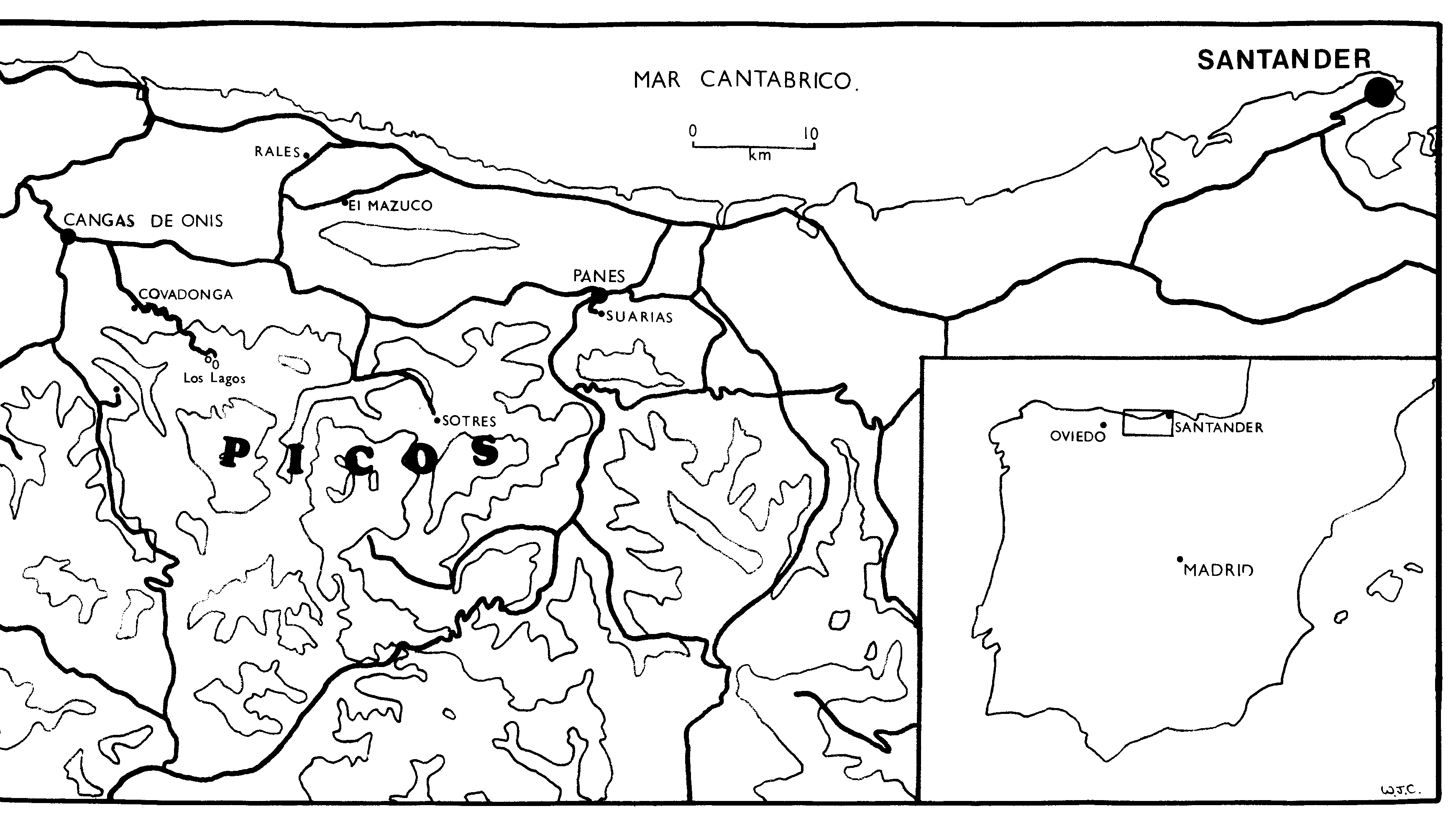
The presence of two serviceable vehicles was a boon to a reconnaissance. It enabled personnel to cover the entire Picos region with relative ease. Camps were made at Rales to the north, Lake Ercina and Amieva the sites of previous Oxford and Manchester U.S.S. expeditions respectively to the south and west. In the east, return was made to the La Hermida gorge and Latarma valley.
Not withstanding the inexperience of the expedition personnel, some 3km of cave passage was surveyed, and an even greater length discovered. For the first time, an expedition log was kept obliging members of the expedition to record their discoveries. This was a very significant aid to writing this report! But most important of all, expedition personnel enjoyed themselves! All the cavers returned for the 1976 OUCC expedition.
Picos Sketch Map. The massif to the immediate east of the Picos de Europa, between the Rio Deva gorge and the Rio Lamason contains some of the most recently exposed carboniferous limestones of northern Spain. Known as the Sierra della Collada, British interest in the caves of the area started in 1973 when the Birmingham University Speleological Society based in La Hermida explored Pozo del Inferno and other caves of the Deva gorge. Two of us, (Mike Cowlishaw and Bill Collis) were present on that expedition.
Sierra de La Collada Sketch Map. Interest in the area was renewed in 1975 when a local farmer told Bill of the series of six cave "tunnels" formed by the Latarma river in the Venta de Fresnedo area. The entrances were soon found and the details were published by Oxford University Cave Club (Proc OUCC 8). It had been hoped to explore the systems in 1976 but permission was unfortunately temporarily denied by the Santander authorities. However permission was granted for that part of the area in the neighbouring province of Asturias (where we did have permission) and over which Santander had no jurisdiction. Accordingly Bill and a group of three Imperial College cavers explored the caves south of Suarias (near Panes) during the very wet easter of 1976 and surveyed Cueva el Arco and Cueva Cabanuca. It rained 17 out of the 21 days we were there, but this did not prevent us from having a very enjoyable expedition! A trip was made to Cueva La Huerta in flood, and a tooth, later identified by the British Museum as a canine of the extinct cave bear (Ursus Spaeleus) was found in the upper levels. This reconnaissance served as a prelude to the attack on Forcau planned for the summer of 1976. In fact the 4 attempted to reach Forcau, but turned back due to deep snow.
It is unfortunate that OUCC never returned to this area. The 1976 and 1979 expeditions were to duplicate exploration in Cueva del Osu, Hoyo la Madre, La Huelga, Cueva del Viento, Cueva Campana, Pozu el Texu but all these had already be thoroughly explored (and many surveyed) by previous expeditions. The virgin territory to the east was ignored and opportunities for original exploration were lost.
In the 1980s waves of expeditions from STD Grupo Espeleologico Standard who had read the Proc OUCC 8 and were exploring caves and potholes of the Latarma valley. Their spectacular finds included Torca del Joyu las Munecas (Asturias) near El Seguedal with a depth of 223m and length of 4.2 km, which resurges at La Huerta, Torca del Tocial (-190m), Torca del Cuevón (-147m) and Torca de la Cumbre (-92m). See Cavidades y Senos 1-1986, available from Associación Deportivo Cultural STD, Labrador 10, 1 B, 28005 Madrid.
Near the Estragueña bridge in the Deva gorge, one can see a chasm, partially hidden by vegetation on the far side (west) of the river. This is the entrance of a short rift passage leading to a deep sump - a spectacular Vauclusian rising possibly explored by the Speleo Club de Dijon in 1962 and 1963. (A. Delingente). They reported hearing the sound of water through an impenetrable crevice in the wall suggesting that open cave continues beyond the sump.
Mike Weeks and Bill Collis revisited the cave in 1973 as part of the Birmingham USS expedition in an attempt to free dive the sump. Thinking that Bill had reached dry land Mike generously paid out the line. In actual fact Bill was frantically attempting to pull himself back! The sump is very deep, well below river level as we verified by lowering a lead acid lamp on the rope into the clear waters.
'A further visit would almost certainly yield new passages' (3) - how often is this kind of statement met in expedition reports. However the writer had promised himself the trip, and so two years and two expeditions to the Picos later, a return visit was made to the La Hermida gorge in the company of Martin Laverty, Steve Newton and Bill Collis. After meeting a Spanish team from Barcelona, who were planning to resurvey the cave over the next few days, we sweated up the hillside and eventually found the entrance. A fairly direct route through the cave soon brought us to the previous limit of exploration.* An easy but cold duck was soon passed - this led to the beginning of a deep, wide lake winding off into the darkness. Not being equipped for, swimming a retreat was made back out and down to the Spanish camp at Coto del Infierno. On discussing this find with the Spanish cavers it transpired that one of their members had stumbled on the lake while lost some three years before - but had been unable to find it again.
The next day saw Bill and Mike back at Coto del Infierno to guide the Spanish surveying team to the lake. After helping them carry their rucksacks, tents, dinghies etc. to the Talps gallery we eventually got to the lake. A fine swim led to a disappointing boulder choke. An Anglo- Espanol pushing attempt was unsuccessful but several new side passages were explored for some distance. Eventually we left and were well entertained by those Spaniards who were not camping inside the cave.
*S.E.S. TALPS had explored and surveyed the cave up to this point about five years ago. This is 1km beyond the point described as the 'limit of exploration' in (5)
Suarias was first chosen as a caving base in 1976 because the map, (number 56 on the 1:50,000 scale Edición Militar series) showed two pairs of major depressions to the immediate south.
South of the north west depression a natural rock arch can be seen and a small cave entrance can be found a few metres away. Hence the name Cueva del Arco. The cave rapidly opens out inside to a very large chamber but the dry stream bed is choked with mud after 100 m. (Surveyed in 1975 and 1982 but never drawn up!) The north west depression does not take a stream but does contain a small cave at the bottom (10m long!).
The north east depression takes the biggest stream of all but frustratingly the sink is silted up with mud, stones and vegetation. One can hear the water fall inside the sink which does seem to indicate real cave passage. There are some alternative sinks but these too are all impenetrable. Alas it will take a major effort to dig into any cave system here. The results could be quite spectacular however as the depression has a large catchment area, not all of it limestone, so the substantial stream could still be quite aggressive.
The track from Suarias degenerates into a path which skirts round the east of the big depression and climbs south to a pass into the Hondo del Valmayor. The pass itself at 770m is full of unexplored depressions. The Hondo del Valmayor is a big, steep depression containing a small stream which sinks at the foot of a shallow saddle (at 559m). There is no cave but possibly a potential digging site if anyone is prepared to climb this far! Beyond the saddle one would have expected a resurgence. On the contrary there is a small impenetrable sink (at 592m). Further west the ground is increasingly flat at about 600m. Near the ruined buildings cows use a blocked 30m cave as a shelter from the sun but there seems that there is nothing very substantial.
Looking at the map it would appear that the same geological feature (a fault?) that has created the Hondo de Valmayor has also created the speleologically interesting Latarma valley and indeed the depressions between La Herreria and Venta de Fresnedo. The feature must be at least 10 km long. Maybe longer because further caves are to be found in San Esteban (Cueva de los Jares, Omnibuss 5, 1973).
The 1:50,000 map shows a small depression immediately to the north of Suarias. Actually there are two cave systems which take the same stream. The first is the Oyo Cenal, (alt 168m) unexplored, but probably a wet through trip of 50m containing a small pitch. The water exiting from Oyo Ceñal then sinks in a fine cave entrance, (alt 146m) La Redonda which was explored for 50m to a deep pool. The cave continues. The lack of enthusiasm for these two caves may be explained by the nature of the stream. It drains the sewage, animal and human from Suarias.
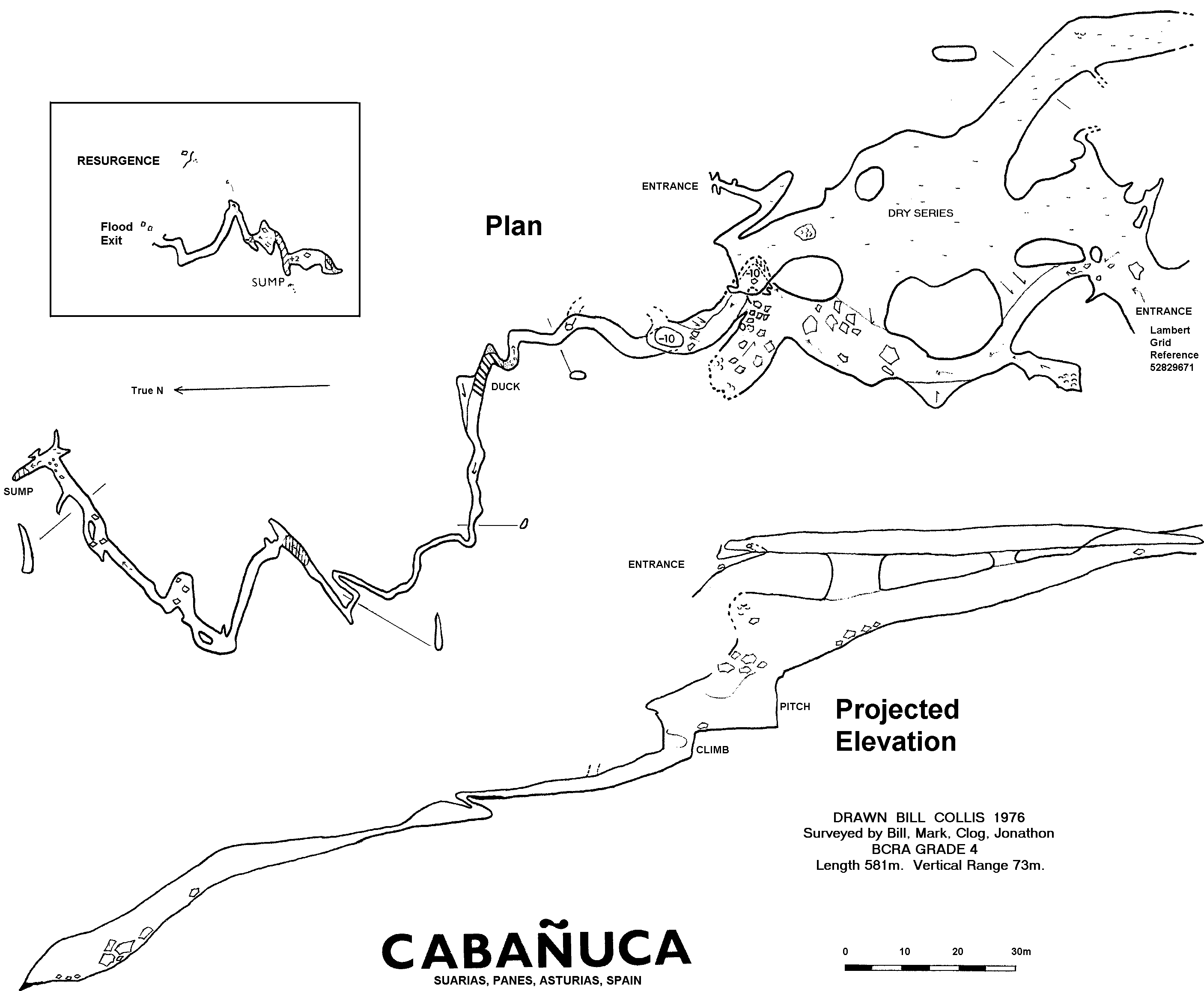
Survey This cave was probably partially explored by the Speleo Club de Dijon in 1962 and 1963. (A. Delingente, Sous le Plancher, T.2, Fasc. 4, 1963: 52-64) and a survey was long overdue. Cabañuca is best approached by driving up the track leading south-east from Suarias, (near Panes). After 500m take a left turn at a small quarry and follow down for some 200m. The large entrance is visible (to the east) from the saddle. To the west a big depression contains a stream and an impenetrable sink. Further west is yet another depression and an impenetrable cave entrance.
Cabanuca`s entrance is just below the top of the limestone ridge which blocks off a sandstone valley. Two ways lead on; a horizontal bedding plane dry complex, much beloved of Spanish cows, and the main stream passage on the left. The two interconnect frequently via steep boulder slopes. A side passage of the dry series leads to a small entrance overlooking Panes, presumably a relic resurgence. The real resurgence may be heard from this point in wet weather (52839673).
The stream passage continues to a ten metre pitch which can be bypassed by a sporting free climb on the right. On the left a crawl through stable boulders leads to the top a simple 3m pitch. Another pitch of 10m is again free climbed on the right. The vadose passage becomes progressively more phreatic looking and higher dry passages become stalled over. Progress is only possible at stream level and the roof rapidly lowers until a sandy duck is reached. The duck probably sumps in very wet weather but can be quite dry in summer. The other side of the duck the passage unexpectedly continues but remains narrow, sometimes low, but is nevertheless a pleasant sporting trip. One hundred metres further on it opens out and after a few short climbs the terminal sump is reached.
One would expect the water sinking at Cabañuca to be fairly aggressive coming from a sandstone valley. It is surprising to find that tufa is being deposited in the streamway as close as 100m to the entrance. The solution to this enigma may be that the tufa is deposited in dryer conditions when percolation water rather that surface water is feeding the underground streamway. Supporting this are our observations that even when there is no water sinking at the entrance (and no major inlets) there is nevertheless a streamway inside the cave. Secondly tufa is only found in the deepest parts of the stream.
The presumed resurgence is very difficult to find in summer when undergrowth hinders progress on the surface. It is useful to know that it supplies water (to Panes?) so one can follow the pipe. The flood bypass entrance can be crawled into and leads to some 40m of passage.
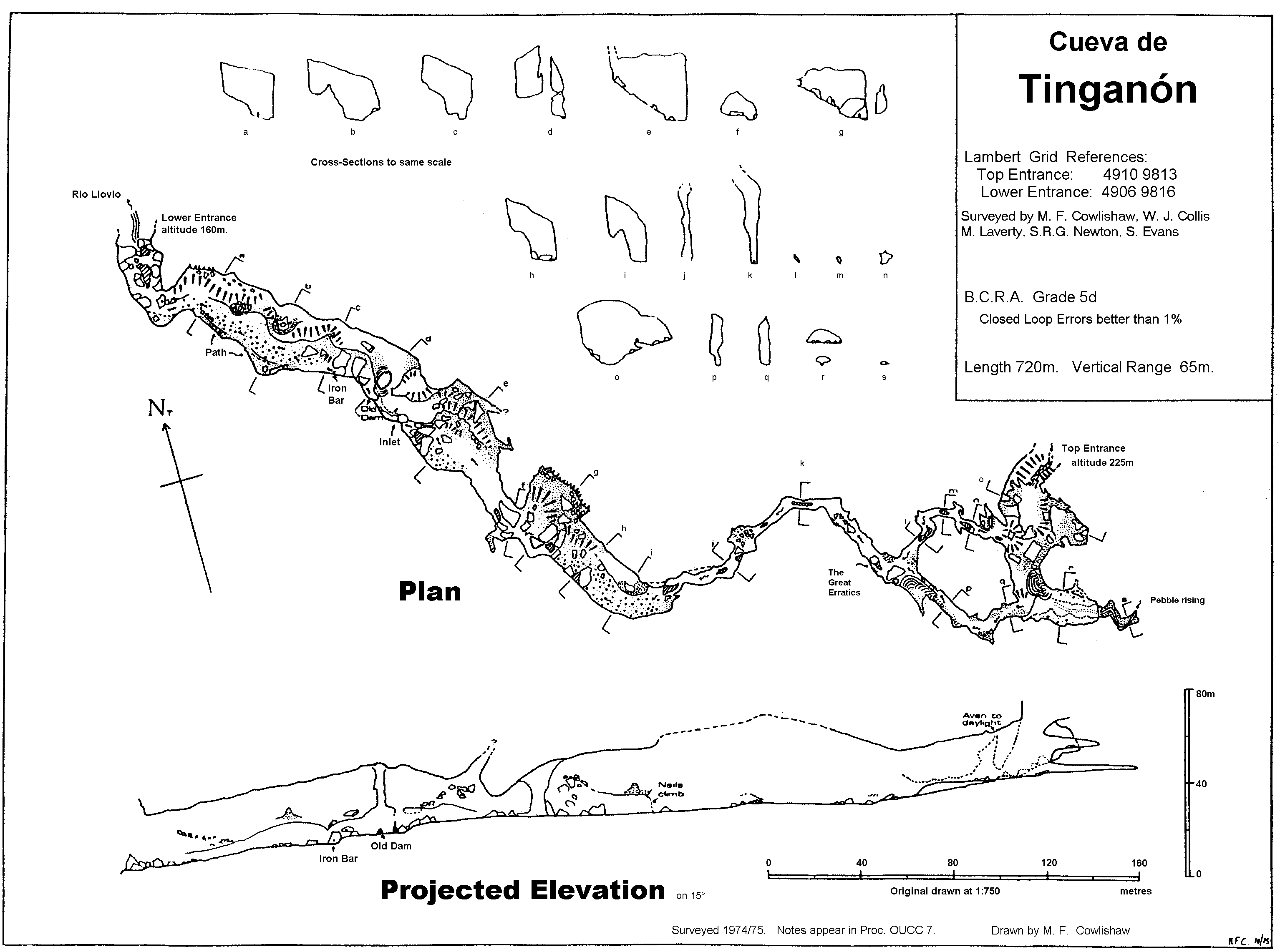
Instruments: First and third surveying trips used Suunto compass, pendulum clinometer, Fibron tapes. Second surveying trip used Suunto compass and clinometer and Fibron tapes, however, the clinometer was found to be faulty, so only selected parts of the data were stable,
Methods: Both leap-frog and follow-through techniques were used, zigzagging in the larger parts of the passage. Readings were taken to the nearest half degree and ten centimetres.Instruments were hand-held with especial care being taken to maintain station positions to better than 10 cms.
Calibration: The compass was calibrated using the Pole Star and mountain- top to mountain top bearings and relying on maps.)
B.C.R.A. Gradings: From lower entrance to upper rock pillar: Better than Gr 5. Loop near top entrance:Better than Gr 5. Central rift: Gr 5 All detail to grade d - much entered on working drawing of cave while actually in the cave.
Calculations: A sophisticated network-solving computer program was used to calculate coordinates and compare the various sets of data (the program is interactive and uses a weighted least squares method to solve networks - see B.E.C. Cave Notes 1975 (in prep). Calculations were initially made in the field on a pocket calculator - this showed the errors in the second surveying trip and so proved to be a worthwhile exercise.
Closed Loops: A large number were available since much of the cave had been surveyed several times. Misclosures for the second surveying trip were horrendous due to the gross errors attributable to the faulty clinometer. (Very little of the data from this trip was used in producing the final line). Misclosures after resurveying were good - e.g. 0.647m for the top loop. Errors were distributed appropriately by the computer program described above.
Plotting: The master line was laid out by another computer program at a scale of 1:750,and the survey was drawn on Permatrace to maintain integrity. In all, 1600 metres of surveying was carried out for the 720 metres of passage. PLEASE DO NOT ASK US TO RESURVEY!
| S----+---->N |
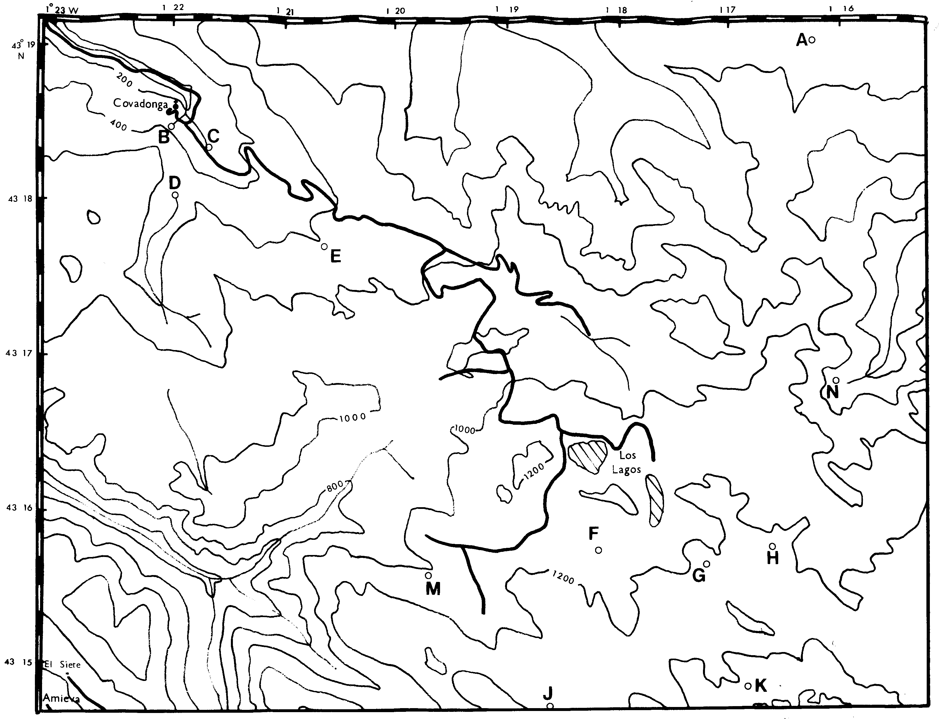
System 6 Riu Praucu Open resurgence entrance @498m
Sink @470m. System 5 (saddle @474m) El Seguedal Resurgence with stagnant pool @442m. Possibly impenetrable.
Torca del Joyu las Munecas Big entrance @625m 4.3 km long, Vertical Range 230m
Sink @423m. System 4 (saddle @430m) La Huerta Resurgence cave with 2 big entrances @386m. Grid 53289646. Length 130 m. Vertical Range 30m.
Sink @ 381m. System 3 Comaria Open resurgence cave @370m explored for 50m. Main Sink @341m Flood bypass sink @350m. Cororigo System 2 (saddle @396m!) Resurgence cave @270m. Grid 53379646. Length 204 m. Vertical Range 22m.
Sumidero (Cueva) del Toyu @171m. Grid 53499643. Length 1 km. Vertical Range 64m. Sistema del Toyu System 1 (saddle @209m) Manantial del Breno - impenetrable resurgence at river (Lamason) level @144m.
Notes. All the sinks are probably impenetrable and all the resurgences seem open cave entrances. An exception to this rule is Toyu for which the contrary is true.
Survey This large entrance swallows the Latarma river which even in dry conditions has a flow of some 100 litres per second. This makes the 14 m pitch situated some 50m inside very exciting. In wet conditions a constriction deep inside the cave causes the water to back up. We found evidence of flood debris 20m above the lowest point of the system. However locals inform us that the entire system floods and the water overflows the saddle!
The Latarma resurges at la manantial del los Baucos, altitude 144m, close to rio Lamason, and is impenetrable. However both the two high level entrances, la Torca el Fresnedo and Cueva de Rozada give access to all the cave below the Toyu pitch without the need for any tackle.
The narrow but deep duck at the entrance to this major resurgence in the Latarma is a little off putting but rest of the cave holds few obstacles. Alas the streamway closes down after 200m and the sink for the system some 80m above appears unpenetrable due to flood debris. STD called this system 'El Cincho del Agua'. They ventured past the duck but there grade 1 sketch shows only half the cave and no description was published. The sinks at 341m and 350m are impenetrable.
This resurgence was only explored for 50m in 1975 but STD surveyed some 250m a decade later.
Two large easily accessible entrances give rise to chaotic vertical development. The stream rises from an impenetrable boulder ruckle inside the cave.
Sketch Map. It was realized at the planning stage of the expedition, that liaison with other speleological groups would be essential for successful original exploration. Far too often, OUCC ignored this basic rule only to find themselves duplicating work of previous years. In 1974 Bill Collis and John Forder had found the Forcau shaft at an altitude of 1470m south of Lago Ercina in the western massif. They later met ESIEC who were slowly exploring it. Regular correspondence continued from England and we met again in 1975. However the catalan group were unable to agree on joint exploration that year and by way of apology, (and although unasked for) gave us written permission to explore all 'their' caves.
On the night of August 5 1975, we met a party of cavers from Speleo Group Alpin Languedocien (SCAL) at the Ercina bar (Maria Rosa). They had been looking unsuccessfully for Canto Ceñal which had remained unbottomed after their 1964 expedition. It turned out that Canto Ceñal and Pozo de Vega el Forcau were one and the same, but this was not realized til the following year. It was decided to plan a brief assault on the pot and the following day was spent finding the rather small entrance.
The first party (Philippe, Francois, Gilbert, Pierre, Alain, Mike and Steve Newton) entered Forcau at 12:30 pm on August 7. Bill, with a second party, followed 3 hours later. The entrance pitch is a free hang of 11m - no snow plug present in August. Pitches 2-4 are of similar length. The 2 parties met at the top of the 5th pitch which is a superb 37m free hang into a large chamber. After a further 4m free climb the 6th pitch is reached - 25m free hang - fortunately out of the waterfall which enters at this point.
Here the stream meanders in a rather tight, deep and sharp rift. With so many people pushing routes at different levels, much energy was needlessly expended. It was clear we had too many people down the cave at once, and after some hours, some of the first party decided to retire. As Steve Newton, a novice caver, had never done SRT before Mike valiantly agreed to escort him and some french out. The rest of the party decided to stop for cuisine francais (dried apple, sponge fingers, cheese, sardines, hot sauerkraut etc.) whilst the 7th pitch was bolted. This was rigged as an abseil, but a ladder, if we had had one would have been much more suitable in such a confined space.
From here on the passage did indeed open out, but only slightly. Pierre went ahead and returned saying he had reached a duck. We decided to commence detackling before we all became exhausted. In retrospect this was a mistake. The duck was easily bypassable by a maze of large oxbows which all could have explored. Whilst we were all probably too tired to descend the 8th pitch, we might have seen the inscription "SCAL 23/8/64" on the rock above! In any case we had reached the 1974 limit of exploration by ESIEC in a single trip!
Meanwhile Gilbert had been unable to ascend the 6th pitch. Mike and Steve had arrived there at 7 pm and it was now 9:30. Mike had climbed the 5th pitch but descended again to help Steve up. The 2 waited some time for Gilbert and then exited the cave at 10:30pm.
The detackling party met Gilbert at the 6th pitch around 9:40. We discussed returning with ladders to help him up but eventually he managed it with Bill encouraging him from behind. He reached the 5th pitch at 11pm and the entire party waited a further 90 minutes for him to ascend this. At the third pitch Gilbert had left the rope snagged and Bill fell 1m when the rope subsequently slipped under his weight. No harm done. Meanwhile poor Gilbert was vomiting above!
We exited the cave at 2am and feasted on bread. Although the bread somehow tasted of carbide we were so hungry that we devoured it! The party reached camp at 4am.
ESIEC had given us a copy of their survey made during a gruelling 35 hour long trip over Easter 1975. This is a very wet and cold season in the Picos. During easter 1976 we attempted to walk to the Forcau entrance but the fog and snow obliged us to turn back! ESIEC report the Forcau stream temperature to be an icy 2 degrees in April, reflecting its origin from melting snow. There was some disappointment expressed in the log, and in subsequent OUCC Proceedings 8 that the Spanish group had exaggerated their findings. They had claimed a depth of 350m to the confluence with the cave continuing. Survey in 1976 showed a total depth of only 258m! It seemed incredible to naive British cavers not only that they could have miscalculated the depth so dramatically but also that they turned back within 5 minutes easy walk from the end of the cave!
Reflection will show that OUCC has been guilty of similar exaggerations. Pozo de Alfonso, aka Pozu la Texa, was supposed to be 185m deep according to the 1963 Oxford Derbyshire expedition. The 1976 survey showed it to have shrunk to just 136m! As for turning back in the absence of obstacles one recalls the OUCC 1972 exploration of Tinganón in 1972 or Purón in 1970!
As for Forcau, we must recall that ESIEC had been 35 hours in the cave without wetsuits. The water levels were much higher. Once again one recalls how OUCC (in 1972) retired from Tinganón without completing the through trip because they were afraid they might reach a pitch for which they did not have tackle. In fact no tackle is required in Tinganón! The moral of the story is that is all to easy to be wise after the event. If Forcau had been deeper, how far would OUCC have got? On July 12 1976 2 parties totalling 5 cavers took more than twelve hours just to get the bottom and back. This compares with a 'par' time of say 4 hours. The sluggish progress reflects the limited experience of OUCC on their first SRT expedition. (Not everyone had attended SRT practice in the UK!). Secondly personal SRT equipment was sometimes inadequate. The expedition secretary had to distribute some 10 carabiners and 20m of nylon tape (which he had bought personally) to expedition members.
Brian's wetsuit decides to fall apart.
Tony's light fails.
Jason & Dot get lost.
Brian decided to test breaking strain of foot loop..!
1) Bill Collis, "Notas sobre El Pozo de Vega el Forcau, (Picos de Europa, Asturias)", Cuadernos de Espeleologia (1982) 9-10, pp 291-294.
2) Carlos Puch. Cavidades y Senos 1-1986, available from Associación Deportivo Cultural STD, Labrador 10, 1 B, 28005 Madrid.
3) Omnibuss 5, 1973. Journal, Birmingham University Speleoloqical Society pp 10-12.
4) SES Talps del Centro Excursionista de Valles, 1971, "Cavidades de la Zona de La Hermida (Santander)", Cuadernos de Espeleologia 5-6, pp pp 231- 250.
These pages were scanned in by Bill Collis.