OUCC Proceedings 3 (1964)Whitewell Pot, Bowland, Yorks. |
OUCC Home Page |
Even the most ardent Lancastrian will admit that, when it comes to potholing, Yorkshire is the supreme county. Mention the word "pothole" to a layman, and Gaping Gill springs to mind. Every potholer worth his salt will sooner or later gravitate to the slopes of Ingleborough, to the long recognised Mecca of spelaeology. But only a few know the caves which lie a few miles further south.
The southern boundary of the Great Scar Limestone in which the Yorkshire caves occur is marked by the Craven Fault system, which passes through Ingleton, Settle and Malham. This line is an important geographical boundary; during the first period of the Carboniferous it was a shoreline, and later, though still within Lower Carboniferous time, it marked the boundary between shallow water to the north and deeper water to the south. The southern deposits are markedly different from those to the north; consisting of calcareous shales and impure limestone on which Karst processes have little effect.
Within the southern area, however, there are some small patches of purer limestone which are more easily affected by processes of solution. These are the deposits of reef-building algae, and at the time of their formation, shales were deposited round them. They have now been exposed by recent erosion, and the shales, being less resistant than the limestones, have been worn away more rapidly, so that the reef deposits stand out as steep-sided craggy hills. The largest concentration of "reef-knolls" lies on both sides of the River Hodder, in the vicinity of Whitewell, and in them there are several small caves. The largest of them is Whitewell Pot.
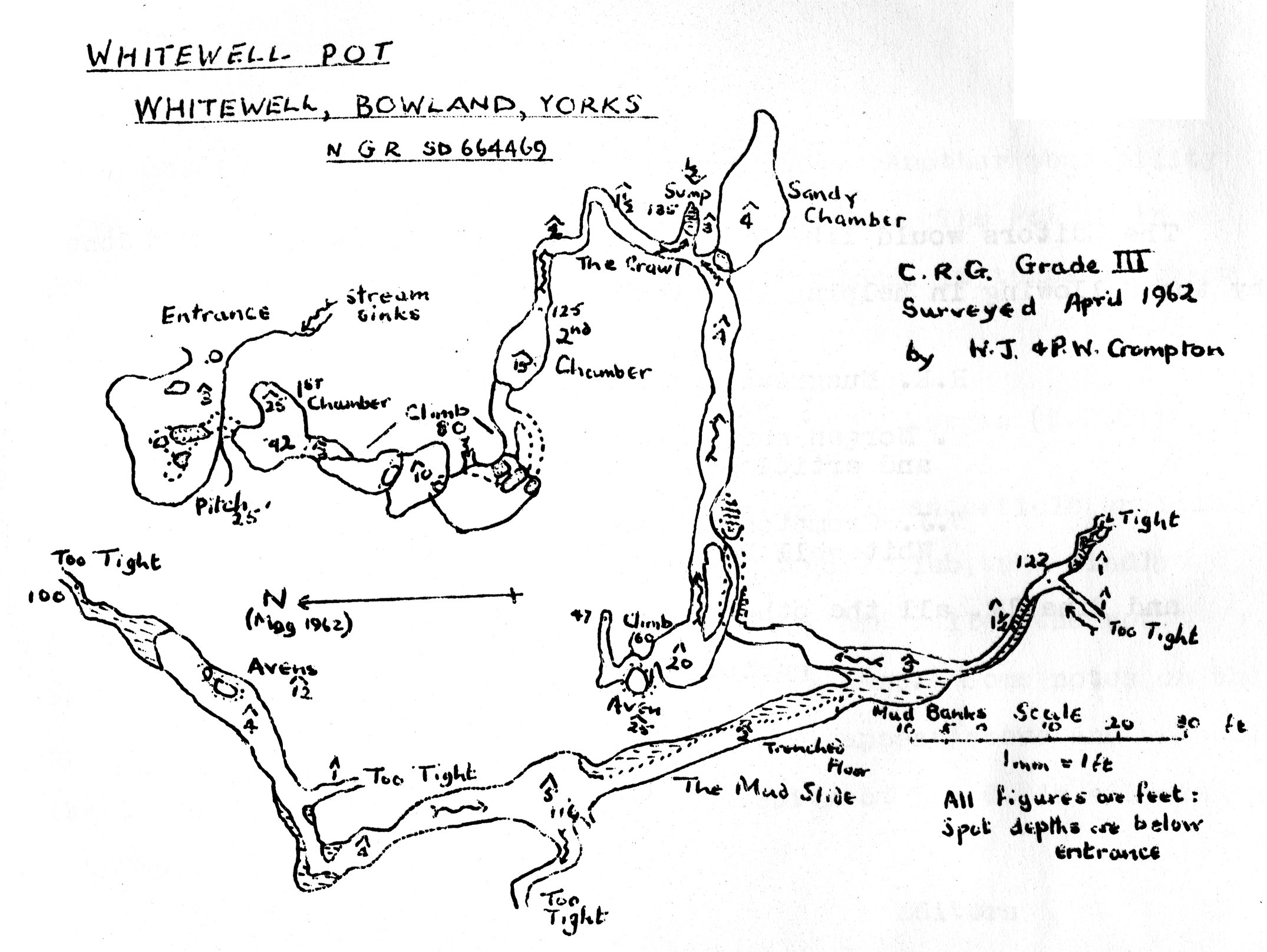
In "Britain Underground", the pothole is graded as a Difficult Pot, and is described as being 160 feet deep, and lying on the left of the road from Whitewell to Cow Ark. I agree with the grading, but not with the other details. The cave lies on the south side of the road, which is the right hand side, and its depth is 135 feet. The entrance to Whitewell Pot is a wide funnel-shaped hollow about 20 yards south of the road at an altitude of 530 feet O.D. (O.S. 1/25,000 map Sheet SD 64, N.G.R. 664469). This is on the up-hill side of a small wood, and the hollow itself is planted with young trees. Down the side of the hollow a small stream trickles, to disappear at the foot of a low limestone cliff. Access to the cave is at a point 10 feet to the right of the sink, through a low hole partially blocked by a rotting tree-trunk (see survey).
The entrance gives access to a low chamber which slopes down at a steep angle. About twelve feet in, there are three holes in the floor which give access to a short rift running S.E. to the head of the first pitch (25 ft.). It is possible to climb this pitch with a rope, but a ladder is useful (belay at the top of the three holes), especially as the trickle of water at the top is aimed directly at the back of one's neck! The bottom of the ladder gives on to the boulder floor of the first chamber, which is a crescent shape, with two 25 foot avens, one for the ladder and one for the stream from the surface. This showers down the right-hand aven and sinks through the boulder floor.
The way on lies under a rock arch on the south side, and over a bank of pebbles is the head of the second pitch. To call it a pitch, however, is misleading; it is a series of climbs, at a general angle of about 70° with a total drop of 80 feet. There are three small chambers, arranged on top of each other, and a tight hole in the floor of each one leads into the roof of the next. A 120 foot rope, attached to the foot of the ladder, is useful, especially in wet conditions, and this cave, on account of its small size, can be very wet.
At the bottom of this climb is the second chamber, oval in plan, higher (15 ft.) than its greatest width (9 ft.). At the far side the small stream which has collected from various corners on the 80 foot pitch disappears down a narrow tube which leads to the sump, at the lowest levels of the cave. The tube is never more than two feet in diameter, and often considerably less, and the sharp bends do not help.
When I first visited the cave in April 1958, the sump marked the end of the cave, and it was just about possible to turn round without falling into the shallow scum-covered pool. On my second visit, however, in the summer of 1960, this pool had disappeared, revealing a pebble floor, which was swallowing the stream from the tube quite easily. Not only this; another stream was now apparent, flowing from the far side of the chamber. It was possible to squeeze under a low arch, into a cave passage bigger than any in the first part of the system. The opening up of this recent set of passages, though they do not go any deeper, has trebled the length of the system.
The first part of the passage is of rounded section, about 5 feet wide and 4 feet high. This slopes upwards at an angle of 15° for 35 feet, where it divides. The upper part, from which a small trickle emerges, slopes steeply upwards to the foot of an aven, where it is possible to climb a further 60 feet upwards into a rift, floored with loose dark boulders, similar to those on the floor of the first chamber. This point is 47 feet below the entrance, and five feet below the floor of the first chamber, but the survey shows it to be nearly 50 feet away. The water coming down this aven is not, therefore, likely to be that which sinks in the first chamber.
The lower series of passages is completely different. In contrast to the rest of the system, it is approximately horizontal, and there are wide banks of sticky mud at the sides of the small stream, which trickles from two very small tubes, too tight to penetrate. A dry passage on the left is the largest passage of the system. It has a mud floor which has been trenched by a stream, on the left side of the passage, at some time in the past. The small trickle which flows in the upper part of this passage disappears down a small tube blocked by pebbles, and it is therefore independent of the cave's main drainage pattern.
Above the sump there is a sandy chamber, which slopes upwards. This was being dug by a group of potholers at Christmas 1963, and they reported about 10 feet of passage leading eastwards. This is the extent of the system to date.
Unlike the Great Scar Limestone, which generally contains smooth walled cave passages (except in the area of the Dent fault), the reef limestone develops a multitude of very sharp edges under solution. Hence this cave is full of razor edges, calculated to tear chunks out of the toughest of boiler suits. The first part of the cave is very clean, but this is more than remedied in the second part. There are very few formations, the only ones of note being a group of clear straw stalactites in one of the avens beyond the Mud Slide.
In the reef limestones bedding and joint planes are poorly developed and it is difficult therefore to assess the part played by structure in the development of the cave plan. The survey shows two general alignments at an angle of 75° , and these directions, N.W./S.S.E. and E./W., probably follow the major joint pattern. The first part of the system, with chiefly vertical development, is characteristically vadose. The second part, with chiefly horizontal development, apparently cuts across the structure and may have formed as a result of the processes described by Swinnerton's theory of cave formation close to the water table. This is not an isolated fragment of evidence for the existence of a water table at this level; along the Hodder valley on both sides of the Whitewell gorge there are wide level terraces between 350 and 400 feet O.D., marking the former level of the valley floor. The water table associated with this valley must have lain close to the level of the horizontal passages at 410 feet O.D.
The system is apparently of pre-glacial formation. The lower levels of the Hodder valley have a covering of boulder clay pointing to erosion below the 350-400 ft. level in pre-glacial times. The water table would sink in accordance with the trenching of the main valley, and the development of caves, according to Swinnerton's theory, could not take place. At the moment the small streams in the cave are removing a deposit of gravel and boulders, which have choked the system. These were probably washed into the cave during the glacial period.
The water from the cave reappears near Whitewell at a point about 300 yards west of the cave entrance at a level of 370 feet O.D. This rising is quite strong and must contain water from other underground streams on the same hillside. The water emerges under pressure and in order to gain access it would be necessary to blast away the upper part of a rock barrier to lower the water level.
There are three smaller caves and several small sink-holes in the vicinity of Whitewell Pot, and at least three more caves on the west side of the Hodder valley, one of these being Fairy Holes, where archaeological excavations took place about the turn of the century. It is hoped to describe these in a later article in this journal.
W.J. Crompton