OUCC Proceedings 4 (1966)Cave Development in the Western Cantabro-Asturic Mountain Chain (Spain)M. J. Walker |
OUCC Home Page |
Five years have passed since the first Oxford spelaeologists began investigations in the western part of the Cantabro-Asturic mountain chain, and it is convenient to publish some conclusions on cave development in the area. We may never understand all the parameters of cave solution by melt-waters from the deep winter snows which overlay the mountains for six months of each year, but we can define interesting relationships between features due to subterranean erosion and some surface physiographic erosional phenomena.
Whereas the eastern part of the Cantabro-Asturic chain has been well investigated by French 11 and Spanish 26, 29 cavers, especially in recent years, the caves of Asturias and León to the west had received less attention. In the eastern Cantabrians near Ramales (Santander) the deep Sima del Mortero has been explored to a depth of -453 metres, while the fall between entrance and resurgence is -695m. In the neighbouring province of Vizcaya (see map 1) the Torca del Carlista system reaches a depth of 360m. These deep cave systems have attracted may French expeditions to the eastern area of the Cantabro-Asturic range over the past ten years, whilst the Grupo Espeleológico Vizcaíno has recorded 484 systems in Vizcaya alone 26.
The western mountains have been the preserve of British expeditions. except for a visit to the Picos de Europa (Asturias) by the Spéléo Club Languedocien that yielded 100 "cavités" 11 , and an early visit by three French bio-spelaeologists 9 who mainly avoided the higher altitudes. Spanish spelaeologists, relying heavily on the 19th century catalogue of G. Puig y Larraz 29, explored caves in the Torío valley 15. Since 1961 seven English teams have visited the Picos de Europa, working at altitudes untouched by previous visitors;
The more informative references have been asterisked. The last expedition in the list also worked in the Leonese caves around the Torío valley as well as in the Picos de Europa in Asturias.
Accounts of the tectonics and stratigraphy of the western Cantabro-Asturic mountains have been given by many workers (thus 1, 2, 16, 17, 20, 33, 34, 36-39, 42). Here it suffices to state that scant traces remain of the Mesozoic peneplain that was dislocated by the folding that began in the Oligocene 17. Few traces also remain of the SE-NW direction of the ancient Mercynian orogeny, except for some mountains in León 42, and perhaps the NE-tending trench of the Río Cares in Asturias. Tertiary N-S compression has produced compartmentalised blocks parallel to the Biscay coast. One such block, the Sierra de Cuera, has probably deflected the course of the Cares to the ENE. Llopis attributes the platforms encountered at between 1,100 m. and 1,400 m. to a Miocene partial peneplanation. English spelaeologists have studied extensively the Enol platform in the western massif of the Picos de Europa. This is not a level platform, but slopes at an angle of 5° for 4.5 kms up to the bases of the steep limestone pinnacles of the peaks. Everywhere the angle of dip of the massive Namurian limestone (caliza de montaña) is very acute, and often vertical. In spite of the considerable Mesozoic erosion 33, 42, Upper Carboniferous limestones (mainly Namurian) are still present from near sea-level to the summits of the peaks at about 2,600 m.
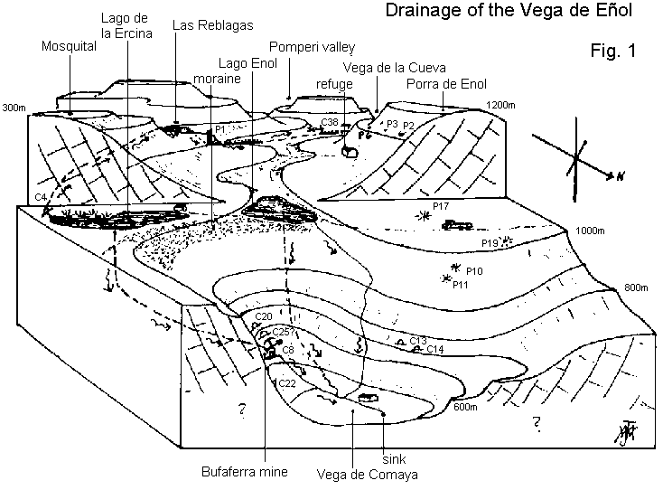
Earlier studies have described in detail the effect of glaciations on the high mountains 7, 22, 33. Traces exist of the Würm and Riss glaciations only. The Würm glaciers seem to have covered land between 1,400 m. and 2,200 m. above sea level, whilst the earlier Riss ice-cap reached down to 1,100 m. above sea level. Around the high peaks at c. 2,000 m. the glaciers have left their mark in the radial corries bitten out of the peaks 7, although no corrie lakes have been formed owing to drainage through well-jointed limestone. Instead, scree-sided dolines of the "jou" type 20 occur between 1,600 m. and 2,200 m. which were formed by nivation. At 1,100 m. in the western massif of the Picos de Europa there occurs the U-shaped Vega de Enol, terminating in a moraine above which are contained two lakes, Lago Enol and Lago de la Ercina. The Vega de Enol is a synclinal valley ending at a large transverse fault at which ice-plucking has occurred 7. Below the fault there is a polje about 1.5 kms long known as the Vega de Comeya. This polje has a mainly structural basis.
By contrast to the Vega de Enol, most of the other valleys on the Enol platform have a V-shaped cross-section, and drain the platform to the NW. Only Cares and its tributary the Casaño drain to the NE, suggesting that they might be superimposed features. The Dobra, Junjumia, Pomperi, and Redumaña begin at between 1,400 m. and 2,200 m. above sea level. The streams sometimes pass underground between adjacent "jou" type dolines, and they descend in steep ravines to the Enol platform. Here, grade is gentler, and pluvial dolines have been formed, some of which must have coalesced to form large poljes such as that of Las Reblagas. Towards the 1,000 m. contour grade increases again, and rejuvenation has caused deep gorges to be cut out. Those streams that have taken an underground course across the Enol platform resurge near this contour. Considerable rejuvenation of the valleys has been attributed to post glacial uplift amounting to +100 m. consequent to the melting of the 1,000 m. thick ice-sheet. (See Map 2 and Fig. 1.)
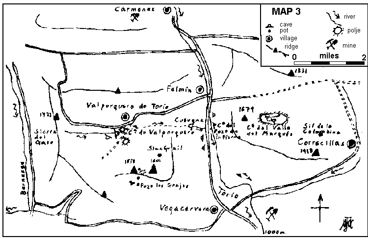
The area of León shown in Map 3 presents a complex tectonic and stratigraphic picture 42. The most prominent feature is the canyon of the Río Torío which is known as the Hoces de Vegacervera. The walls of the canyon are mainly Namurian limestones which in many places seem to be unbedded. Devonian limestones dipping at between 70° to 90° occur at the northern end of the Hoces de Vegacervera. On the west side of the canyon most of the drainage of the Sierra del Gato is received by the Cueva de Valporquero (see fig. 2). Large dolines in which terrace cultivation has been undertaken by the peasantry lie over the upper series of this large system. In a small polje to the south a recent expedition 31 set up a base camp while studying the region. Various "jou" type dolines and associated shafts occur on the ridge to the south at 1,400 m. to 1,500 m. Well-developed lapiaz was also seen, in contrast to the Picos de Europa. Lotze 22 mentions glaciations in León, but these probably did not extend to the region that has been studied. A recent observation of stone polygons in the Valle del Marqués on the east side of the Hoces de Vegacervera testifies to periglacial conditions 31. The extent of recent rejuvenation of the Torío canyon is uncertain. Whilst the lower entrance of the Cueva de Valporquero, La Covona, is perched high above river level, on the other side of the valley at least one large resurgence cave is at river level. This is the Cueva del Pozo de Infierno. It is a very high rift cave in which a wide, deep and very cold stream sumps deeply after being followed upstream for about 300 m. in a dinghy.
The Alpine orogeny in the Picos de Europa has removed any vestiges of earlier karst, apart from the fossil karst seen in geological sections. The Miocene partial peneplanation may have been responsible for the fossil caves of the Sierra de Cuera 20, but generally speaking the features shown by the Asturic caves demand a Pleistocene spelaeogenesis 18, 19. Llopis studied the Cueva de Requeixu and concluded that there have been two "cycles" of cave formation, the second, at least, correlation with the uplift of the coastal terraces early in the Holocene. The initial "cycle" may well belong to the Riss-Würm interglacial. Similar chronologies have been proposed for Alpine cave systems by Corbel 3, 4 and Trimmel 40. Corbel has suggested that even such vast caverns as the Dachstein, Hölloch, and the Beatushöhle could have been formed entirely during the Pleistocene. This suggests a much younger spelaeogenesis for these caves than for British caves on Ingleborough whose formation has been correlated with erosion cycles of presumably far longer duration 35. At any rate, it has been claimed 46 that cave formation does not occur below ice sheets, thus limiting spelaeogenesis to ice-free periods. As at the Cueva de Requeixu, a two-stage formation has been proposed for the Cuevas de Fresnedo 14 which occur 700 m. above sea level in western Asturias, and were formed by successive down-cutting of the Río Sampedro. Interglacial and post-glacial uplift seem to have been the mainspring behind cave formation in the Picos de Europa.
Throughout Asturias and León, tectonic structures have greatly influenced cave development, as has been noted in the Alps by Corbel 4. For example, a group of six shafts including the Pozo los Grajos, shown on Map 3, occur in relation to a minor fault.
Heterogeneity of the limestone is another factor influencing cave formation which has not as yet been adequately evaluated in the Cantabrians. Trimmel 40 noted that dolomitisation of limestone seems to have played a part in dictating cave location. The Cueva de Valporquero begins in a region of the Devonian limestone band (see Fig. 2) where dolomitisation is particularly pronounced, and the La Covona entrance lower down also occurs in dolomitised beds. Dolomitisation is also marked outside the entrance of the Cueva del Valle de Marqués on the eastern side of the Hoces de Vegacervera. Most of the caves of the León region are formed in Devonian limestone more closely jointed that the massive Namurian limestones.
As noted thirty years ago in the USA by Davis 8, steeply bedded limestones such as are everywhere met with in the Cantabro-Asturic chain frequently result in long, vadose cave passages with a marked preference for following the strike rather than the dip of the beds. These systems develop lateral extensions and networks only when they reach the water table. Two influent caves of this genus are the Cueva Orandi (P14, see Map 2), and the Cueva de Valporquero. An effluent cave which utilises two cross rifts is the Cueva del Viento (C15, see Map 2). This cave shows networks of tubes at low levels where the water table is in close proximity. Some phreatic features have also been noticed in Pozo Palomero ( P1, see Map 2 and Fig. 1) at low levels in the cave.
Nivation has been and still is important in the development of many vertical systems which often show traces of flooding in Spring such as might follow the melting of large snow banks. Some shafts have small eccentric entrances in dolines to one side of wide, domed potholes. Good examples of this type are seen in the region marked Las Fuentes in Map 2, and P17 Fig. 1). The Pozo los Grajos pothole (Map 3) is another example, in León, which contains residual snow even in Summer. Permanent snow was not seen elsewhere in the Leonese region studied, although in the Picos de Europa small snow-fields remain throughout the year. The action of snow under pressure in such shafts may also be a component of spelaeogenesis. A large, domed chamber of unknown depth has been noticed in the Picos de Europa which is snow-filled. The snow enters via a small eccentric opening in the roof. A survey of this cave, C16, is given in 28. The deposits of argillaceous material at the bottom of P17, and the traces of flooding observed in this shaft, suggest that it may have been formed by rapid irregular episodes of flooding, which could occur if melt-waters from Winter snow-banks filled the shaft in the Spring. A standing column of water would be expected to dissolve a shaft radially as well as vertically, thus explaining the narrow, off-set openings and the wide shafts beneath them. A high back-pressure might lead to the formation of a dome behind the entrance, or even cause solution along a joint upwards as well as downwards. This may explain the development of Sima Grail (Map 3, fig. 2). The phenomenon of "inverse erosion" of this type has been studied in Italy by Maucci 23, 24.
Many deep shafts occur in curiously perched situations on the sides of hills or in deep dolines. They must be attributed to their having been fed by meltwaters from snow-banks long since disappeared. Three small shafts above the mountain refuge in the Vega de Enol (fig. 1) occur thus perched high on the side of a hill called Porra de Enol. As the valley was once filled with a tongue of the glacier, the position of these shafts might indicate the upper edge of the ice above which snow-banks would have collected. Other examples of perched shafts are the Pozo los Texos, the Pozo de Mohandi, the Pozo Altiquero (Map 2) and the Sima Grail (Map 3). These are much deeper shafts, often quite wide, leading sometimes to steep scree slopes. The scree may be due either to collapse (of a domed roof?) and/or to freeze-thaw. Frost-shattering has played an important part in the development of shafts in the Vega de Enol, where several small shafts are filled with frost-shattered boulders 47. Likewise the present-day entrance to the cave of El Burdio de la Peña is partly blocked by talus from the cliff which overhangs it.
The most important piece of evidence for the formation of caves during the Holocene and the Riss-Würm interglacial in the Picos de Europa is the reversed drainage of the Vega de Enol (see fig. 1, ). Until thirty years ago, water from the Lago de la Ercina flowed down to the Bufarrera mine in the Vega de Comeya to the NE. Recently, the miners have been unable to rely on the lake as a reservoir for their ore-dressing operations, although they still receive water copiously from the Lago Enol. Dye tests 28 showed that underground connections exist between C4 at the southern end of the Lago de la Ercina and the Vega de la Cueva to the NW. Almost without a doubt, the Las Reblagas polje, the Pozo Palomero (P1) cave system, and C38 are connected with the devious new drainage of the lake to the NW. The Vega de la Cueva joins the Pomperi valley, itself a tributary of the Río Dobra. The result is that the water which until recently drained NE, now joins the main pattern of NW-tending valleys which cut across the Enol platform.
The reversal of the drainage of the Lago de la Ercina can only be explained by postulating increased rejuvenation and down-cutting of the NW-tending valleys in post-glacial times, since the lake itself is only a recent, glacial phenomenon. The absence of the tongue of the glacier which once filled the Vega de Enol has removed the impetus behind the rejuvenation of the NE drainage into the Vega de Comeya, and the rejuvenation of the Pomperi and Dobra valleys has thus overtaken that to the NE and so captured the water of the Lago de la Ercina. The Lago Enol, being at a very slightly lower altitude, although still behind the same moraine as its companion lake, has not yet been captured, although one may speculate that in time it will also cease to drain into the Comeya polje.
Since the postulated rejuvenation of the Pomperi valley must post-date the formation of the glacial lakes, the caves formed in connection with the reversal of the drainage of the Lago de la Ercina must be of very recent origin indeed. In short, Pozo Palomero, C4, and C38 must be dated within the recent Holocene period. It is likely that many of the shafts and caves near the Vega de Enol are of periglacial formation, as has been suggested above.
The Burdio de la Peña cave system 32 reflects the rejuvenation of the Pomperi valley in which it occurs. The cave is an effluent cave developed on several levels. An active, joint-controlled vadose passage leads into an upper series which shows stalactites encrusted in bergmilch and an infill of clay only today in the process of slow removal. These two principal levels are reminiscent of the Cueva de Requeixu 18 where Llopis described two cycles of erosion of the following type :
solution / stalagmitisation / clastic deposition
Similar triphasic erosion has occurred in the Cueva del Buxu at Onau near Cangas de Onís 27, 32 where in the terminal chamber a calcite layer has developed on top of clay which has subsequently been partly removed and carried into a youthful lower series. Bergmilch has been seen in many small caves in the western massif of the Picos de Europa 28.
A curious feature of the Burdio de la Peña cave reoccurs in the Cueva de Valporquero. Each cave shows a large daylight effluent cavern, but this is not in direct communication with the mainstream passage. The latter is reached only by means of small, high-level tubes involving difficult climbs. The stream passes between the well-developed main stream passage and the daylight effluent cavern via a sump. It would seem as if considerable infilling has occurred at some stage, blocking the sump and leading to the formation of the phreatic tubes, with a later removal of the infill. In fact, subsequent down-cutting of the Pomperi valley results in the main resurgence from the Burdio de la Peña cavern occurring a short way down the valley from the daylight effluent cavern from which egress has been blocked by talus from the overhanging cliff-face, although it is still subject to flooding via the sump. The lower rising is not passable. Down-cutting has also affected the P1 system, and partial exploration of a once active resurgence in the Vega de Enol has been made 45, perhaps corresponding to the part of the cave believed to approach the surface by the survey team 28.
The chronology of the caves in the Torío canyon is, by contrast, obscure. The La Covona effluent cave of the Valporquero system is perched some 80 m. above the valley floor, suggesting that either rapid rejuvenation of the canyon has occurred following a Pleistocene spelaeogenesis, following a chronology of the type discussed above, or that the cave was formed during the Miocene partial peneplanation, and the rejuvenation of the canyon has followed this. The latter explanation does not explain the failure of the cave passage to keep pace with a gentle rate of rejuvenation which should have led, theoretically at least, to a resurgence at river level. Also favouring a Pleistocene spelaeogenesis possibly is the presence of evidence for the two "cycles" of cave erosion of the triphasic type mentioned above. One may point to the delicate, pendant stalactites of the upper part of the cave system on the one hand, and to the heavy, organ-loft formations and bosses of the lower active passages. Both this cave and the Cueva del Valle del Marqués have been the scene of clastic deposition on a large scale and not yet fully cleared. The two phases of stalagmitisation may correspond to interglacial and post-glacial activity, such as has been proposed to explain similar differences in Alpine caves 4. However, these phases could equally well have occurred in slower erosion "cycles" involving a more extended chronology.
Perhaps favouring an ancient formation of the Cueva de Valporquero - assuming contemporaneity which may be unwarranted - is the occurrence at river level of the large resurgence cave of Cueva del Pozo de Infierno (v. supra). It is hard to believe that this cave whose deep water sumps deeply upstream is consistent with a Holocene rejuvenation of -80 m. of the Hoces de Vegacervera. However, more detailed studies are required before a definite conclusion can be reached regarding the caves of the Torío canyon. Some shafts in the mountains above the canyon have been referred to earlier in connection with periglacial erosion, and are presumably recent. It may be a mistake to assume, and even more so to demand contemporaneity of all the caves in a given area.
The caves of the western part of the Cantabro-Asturic chain show two "cycles of erosion", each corresponding to three stages :
solutional erosion / stalagmitisation / clastic deposition.
One "cycle" probably occurred during the last interglacial, and the other has occurred during the Holocene. In many caves the second "cycle" has reached the stage of clastic deposition. Only very few caves still receive an influent stream of any size - viz. Burdio de la Peña, Pozo Palomero, Cueva Orandi or P14, President's Pot, Cueva de Viento or C15, Cueva Dobros, Cueva de Valporquero. Most other caves receive at the most a seasonal inflow.
The pre-glacial drainage pattern of the Enol platform to the NW has been restored following a fall of base-level of about 100 m. during the Holocene. This has involved capture of the temporary drainage of the Vega de Enol to the NE by the rejuvenated valleys, and eradication of the periglacial drainage into the Vega de Comeya via the Lago de la Ercina. There are some caves which could only have been formed following the reversal of this drainage, and which must be entirely Holocene in their spelaeogenesis therefore. Some questions concerning the spelaeogenesis of the Cueva de Valporquero are posed, which require further investigation.
M J Walker
Weir Common Room
University College
Oxford
February 20th, 1966
1 Barrois, C. Mem. Soc. Géol. Nord 2: 1-630 (1882)
2 Birot, P. & Dresch, J. La Mediterranée et le Moyen Orient, I (1956)
3 Corbel, J. Rev. Géogr. Lyon 32: 43-56 (1957)
4 Corbel, J. Rev. Géogr. Lyon 32: 135-158 (1957)
5 Cowling, J. J. Craven Pothole Club 3 No. 5: 252-254 (1965)
6 Crompton, W.J. Proc. O.U. Cave Club 1: 5-15 (1962)
7 Crompton, W.J. Proc. British Spel. Assoc. 2: 39-47 (1964)
8 Davis, W.M. Bull. Geol. Soc. Amer. 41: 475-628 (1930)
9 Derouet, L., Dresco, E., and Negre, J. Speleon 5: 166 ff. (1954)
10 Dunford, J.A. The Speleologist 1 No. 2: 5-7 (1965)
11 Echos des Explorations 1964 in Spelunca, Bulletin, 4ième S., 4: 37-40 (1964)
12 Robertson, A.C.W. Proc. O.U. Cave Club 4 (1966)
13 Judson, D.M. J. Craven Pothole Club 3 No. 3: 131-137 (1963)
14 Julivert, M. Espeleología de Asturias, I (symp.): 51-74 (1935)
15 La Cueva de Valporquero, Publicación del Grupo Espeleólogo Leonés, 1956
16 Llopis Lladó, N. Trab. y Mem. del Lab. de Geol., Univ. de Oviedo Facultad de Ciencias 1: 2-51 (1951)
17 Llopis Lladó, N. Estud. Geográf. 15: 501-550 (1954)
18 Llopis Lladó, N. Espeleología de Asturias, I (symp.): 75-101 (1935)
19 Llopis Lladó, N. INQUA V Cong. Internac., Libro Guía de la Excursión No. 2, El Cuaternario de la Región Cantábrica pp. 43-55 (1957)
20 Llopis Lladó, N. Monograf. Geol. (Inst.de Geol. Aplic., Oviedo) 10 (1958) (Caves in Sierra de Cuera)
21 Llopis Lladó, N., Fernández, J.M., and Julivert, M. Espeleología de Asturias, I (symp.): 3- 37 (1955)
22 Lotze, F. Abhandl. d. Mathemat.-Naturwissensch. Klasse (Akad. d. Wissensch. u. d. Literatur) Jahrgang 1962 No. 2: 150-169 (1962)
23 Maucci, W. Boll. della Soc. Adriatica di Soc. Nat., Trieste 46: 1-60 (1951-1952)
24 Maucci, W. Atti del VII Cong. Naz. di Spel., Mem. III di Rass. Spel. Ital. e Soc. Spel. Ital. pp. 221-236 (1956)
25 Mills, K.J., & Walker, M.J. Proc. O.U. Cave Club 2: 5-11 (1963)
26 Nolte y Aramburu, E. Speleon 11: 53-159 (1960)
27 Obermaier, H. & de la Vega del Sella, Conde La Cueva del Buxu, Asturias (Junta p. Amplia. de Estud. y Invest. Cient., Com. de Invest. Paleontol. Prehistór. 20, (1918)
28 Oxford University Expedition to Northern Spain 1961 Cave Res. Group of Gt. Brit. Publ. 14 (1965)
29 Puig y Larraz, G. Bol. de la Com. del Mapa Geol. de Esp. 21: 1-392 (1896)
30 Report of the Manchester University Expedition to the Picos District in Northern Spain (1963) (produced by members of the expedition, 1964)
31 Report of the 1965 British Speleological Expedition to the Cantabrian Mountains (produced by members of the expedition, 1966)
32 Report of the Oxford-Derbyshire Speleological Expedition to North-West Spain, 1963 (produced by members of the expedition, 1966)
33 Solé Sabarís, L. Geografía de España y Portugal, I, España Geografía Física pp. 287-310 (1952)
34 Suess, E. The Face of the Earth, II (1904)
35 Sweeting, M.M. Geograph. J. 115: 63-78 (1950)
36 Termier, P. Compt. rend., Acad. Sci. (Paris) 166: 433-439 (1918)
37 Termier, P. Compt. rend., Acad. Sci. (Paris) 166: 516-520 (1918)
38 Termier, P. Compt. rend., Acad. Sci. (Paris) 166: 709-714 (1918)
39 Termier, P. Compt. rend., Acad. Sci. (Paris) 166: 793-799 (1918)
40 Trimmel, H. Festschrift zur Hundertjahrfeier der Geographischen Gesellschaft in Wien 1856-1956 pp. 193-208 (1957)
41 University of Nottingham Spelaeological Expedition - Exploration '64 (produced by members of the University of Nottingham Student Union Spelaeological Expedition 1964 Picos de Europa N.W. Spain) (1964)
42 Wagner, R.H. Bol. del Inst. Geol. y Mín. de Esp. 74: 1-159 (1963)
43 Walker, M.J. Proc. O.U. Cave Club 3: 9-15 (1963)
44 Walker, M.J. The Speleologist No. 3: 25-28 (1965)
45 Walker, M.J., Cowling, J., & Craven, S.A. J. Craven Pothole Club 3 No.2: 66-70 (1962)
46 Warwick, G.T. Trans. Cave Res. Group of Gt. Brit. 4 No. 2: 125-160 (1956)
47 Wilcock, J.D. North. Cav. and Min. Res. Group Newsletters 1: 12-19 (1963)