OUCC Proceedings 6 (1974)Cueva La Borbolla |
OUCC Home Page |
Simon Willbourn
Grid Ref 5231 9737
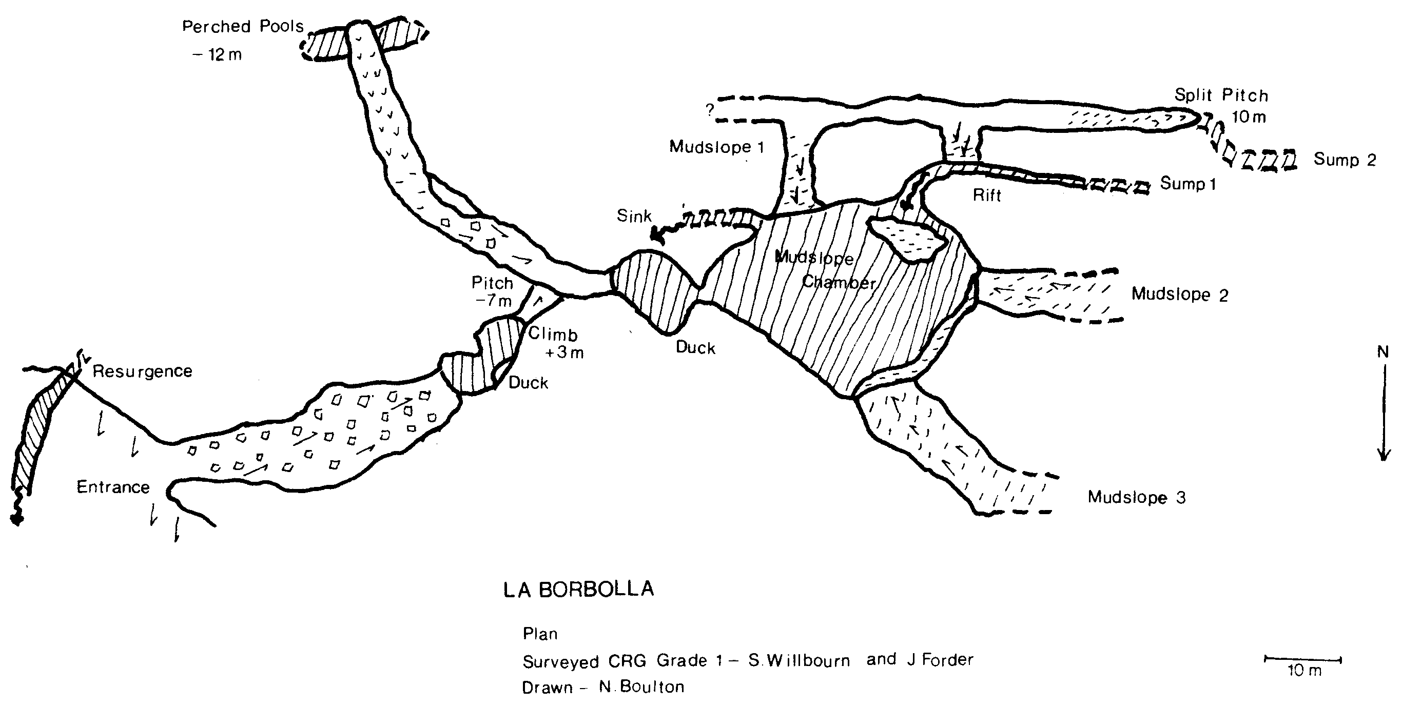
This cave, the source of the Rio de las Cabras, was first encountered by the 1969 expedition during very wet weather, when water was reported to have been issuing forth from all available holes in a cliff face. On our third full day we re-visited the village of La Borbolla, and having dragged ourselves away from the bar, found the cliff after a short walk. The most noticeable feature was a stream emerging from a well defined rift, channelled into a mill race, down the left hand side of the face. The main resurgence was impenetrable from without, but by scrabbling up the hillside through the undergrowth, we reached a spacious archway approximately 4 metres square. This was a dry entrance, although according to reports from 1969 it had led directly to a large lake which gave hopes of a considerable system behind. The floor ran down over boulders and mud to a pool, which was about 40 metres in and 6 metres down from the entrance. John Forder plunged off into the unknown, and when he failed to re turn, that was the signal for Neil and myself to change; pausing only to grab a 10 metre ladder, we followed into the pool.
After swimming for only 5 metres or so, we came to an amusing duck, with an even more entertaining eyehole bypass about one metre above water level. This led to a pool enclosed on all sides by rock and stal flow, which entailed a climb Up of about 3 metres. Round the corner was a pitch descending 7 metres, with a very loose take off and which eventually dropped down a rock wall into a dry stream bed. The route to the left led to another perched pool complex after 40 metres of passage. These two pools were investigated on our second trip to at least two metres below surface level, but no exits were discovered. The route to the right led to another pool and the second duck. Beyond this was a sizable chamber, and off to the left the stream disappeared down a rift. It is certainly possible that the Grade 1 survey is grossly misaligned and that the stream at this point is very close to resurgence; the passages are remarkably similar in form. However, I am not convinced that this is the case, since it seemed to me at the time that the volume of water in the resurgence was greater than that flowing through Mudslope Chamber. Fortunately for the law of conservation of matter, we also discovered the entry point of the water into the chamber. Behind the back of a shingle bank, we were able to follow the stream along a deep and sharply sloping rift, about one metre wide and narrowing to 0.5 at the inevitable sump. John and Neil, climbing the rift in an attempt to find a high level bypass, found themselves at the top of Mudslope 1, which I had found to be an interesting climb, and which proved to be an entertaining descent a good 20 metre vertical distance on a 45° slant. The initial party then left the cave, thoroughly confused as to its structure but still with hopes of a way on.
John Forder and I made a second trip a week later and, besides investigating the static pools as described above, explored the warren above the three mudslopes. We descended the split pitch to two deep pools which we labelled Sump 2. We think these are static as well, but did not survey the level with respect to the stream in the chamber. Anyway, we failed to find a way on and, apart from diving the rift sump in Mudslope Chamber, which should in our opinion be tackled by experts, any attempt to get at the master system which lies behind (?) will have to be made from further up the densely vegetated hillside. It is also conceivable that the character of the cave alters drastically every few years when there is heavy flooding, possibly as a result of a severe constriction somewhere in the system. The vertical distribution of water in the section discovered is, to say the least, odd.