OUCC Proceedings 6 (1974)Cueva la Boriza |
OUCC Home Page |
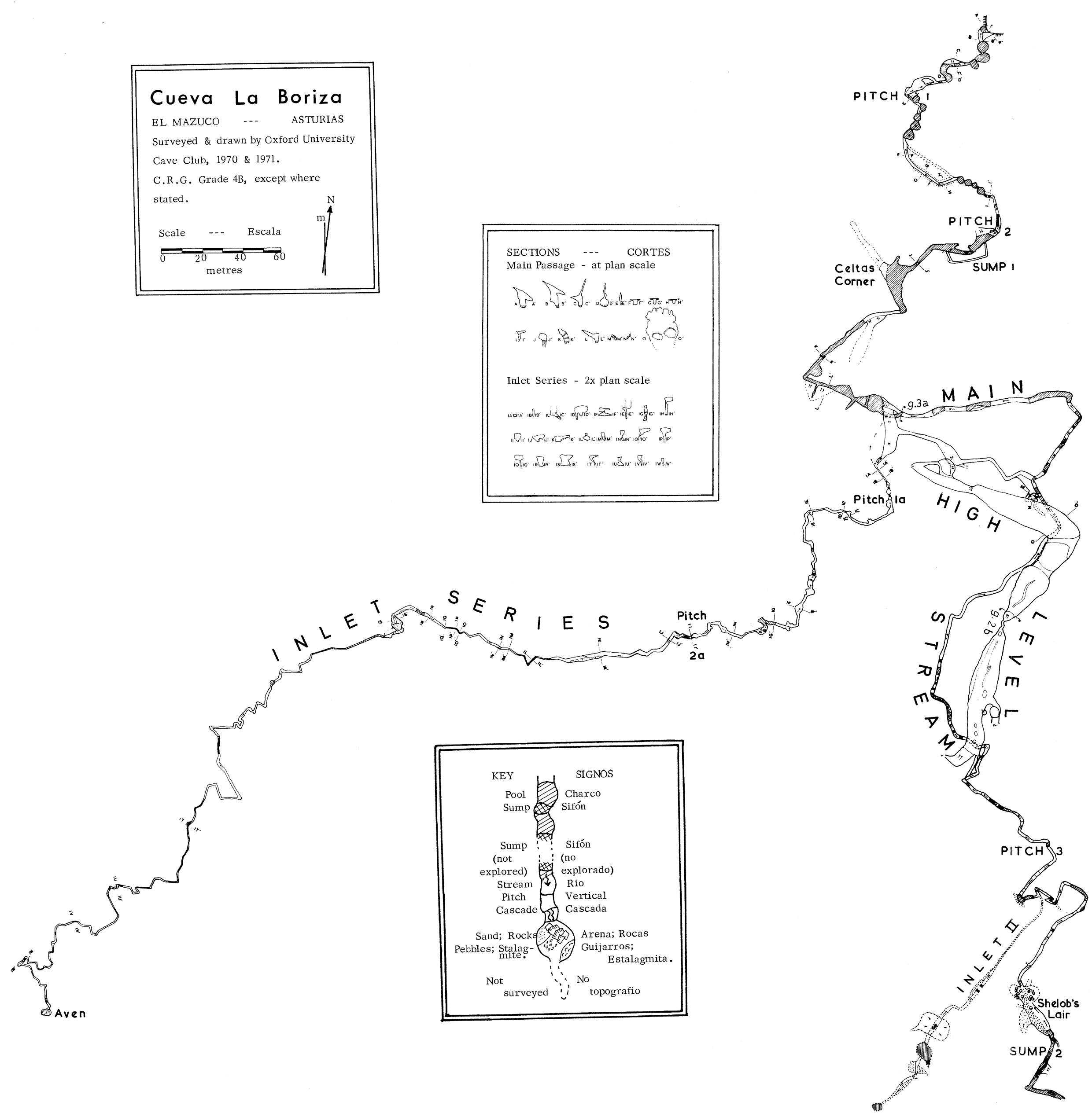
Grid Ref. 5065. 9755.
This resurgence cave was the major objective of the expedition; exploration in 1970 resulted in considerable extensions to this particular cave, one of the principal features of the hydrological system of the El Mazuco area. About 1 kilometre beyond the first sump, a second sump had prevented further progress along the main streamway. Accordingly, this year we took out diving gear in order to try to extend the cave. From the survey, it has a potential depth of 700 metres. The diver investigated the sump soon after arrival, and reported a series of phreatic origin, leading to a third sump. One session was devoted to an attempt to discover a sump bypass in Shelob's Lair. Access was gained, via the maypole, to a hopeful looking hole in the left hand wall, but it did not go anywhere useful. Attempts to extend the cave from the upstream end were therefore abandoned. Several passages, which had been noticed the previous year, were also investigated, two with a considerable measure of success. One was an abandoned high level series of massive proportions, the other a very fine inlet series, which was extended to a length of approximately 700 metres with the help of the maypole. Surveying this extension proved to be a long and hazardous business, since the passage was extremely tight. A deterioration in the weather towards the end of the expedition did not help. As a result, nearly a third of the expeditions effort had to be devoted to Boriza.
John Forder & Simon Willbourn
During one of the trips made into the cave in 1960, a large phreatic passage, situated just beyond the last lake, was investigated by John Forder. The tunnel, some 5 metres wide and 3-4 metres high, slopes upwards at about 300 for about 25 metres, at which point it swings left to regain the main streamway at a high level. Just at this point a small stream was noticed, emerging from a low passage on the right and disappearing immediately under the wall. After a short hands and knees crawl upstream the passage assumed more comfortable dimensions and was followed for about 15 metres to a 3.5 metre pitch. At this point the lone explorer turned back.
Further investigation had to be left to the 1972. expedition. The first party found the pitch to be an easy free climb, but a second pitch of similar size, encountered almost immediately, had to be treated with more deference. At the top of this pitch, a small circular chamber, S 6 metres in diameter, was entered; the water fell down a pitch of some 8 metres on the far side. The stal. covered walls offered no opportunity for free climbing this obstacle. However, since the maypole had already been brought into the cave to investigate the walls of Shelob's Lair, and the chamber gave room for manoeuvre, this pitch was soon laddered.
Access was gained to a fine section of stream passage, with several deep pools, cascades, and some decorations. After some 120 metres, another pitch, somewhat larger than the first ladder pitch of the inlet, prevented any further progress on that trip.
A week later the maypole was brought up the section of streamway to the pitch. This passage is indeed fine for anyone not unduly encumbered by ironmongery, but on this occasion some of the free climbs turned cut to be rather arduous and very noisy. When assembled the pole was about 2 metres short of the top; this last section was therefore climbed by pegging into some dubious rock, a process which took about 15 minutes and resulted in everyone becoming not a little damp. Fortunately we were able to warm up once above the pitch, and a trace to the end was won by Neil, over some 550 metres of stream passage. The 'end' is in fact an aven, estimated to be 25 metres high. The stream descends from a point in the roof, which could not be located precisely because of the spray. It would be very difficult to scale this aven; the walls enjoy the protection of the soapy surface of eroded stalagmite, which is a characteristic of caves in this region.
The inlet series more than doubled the length of Boriza. It is essentially a narrow meandering rift passage, enlivened by deep pools, lengthy cascades, and climbs which have to be treated with some circumspection. It was surveyed to Grade 4b, demanding several trips of long duration. The directions of the main and inlet passages are shown superimposed on a topographical nap of the immediate area; a projected elevation illustrates the relationship between Boriza and the various potholes on the mountain.
There is little hope of finding a way to the top of the aven, since it takes only about half the water which appears at the entrance to the inlet series. Several impenetrable feeders have been observed in the series during wet weather. The volume of water in the ml et is approximately a quarter of the main stream.
No tackle was left on the inlet pitches, so it would require more than a tourist trip to revisit the aven in order to test under extreme conditions the newest artificial climbing techniques.
This passage leaves the main streamway a short distance above the third pitch, and is most obvious to anyone going upstream towards Shelob's Lair. Again, it was John Forder who first investigated this inlet, during the 1970 expedition, as part of the frantic search for a sump bypass. The second inlet was not fully explored this year, although a certain amount of time was put in climbing up and down over sump pools. It is essentially a tall rift passage, narrowing down after the relatively spacious section at its entrance, and later widening into a series of small chambers. Whilst a fairly definite end point was reached at high level, some of the less appetising low level routes were not pushed with any show of force. There was never very much hope that the second inlet would provide a bypass, particularly after Andy Brooks had described the second sump. Then it was found that the Inlet Series was going there was even less incentive to look at yet more sumps. Indeed, the Inlet Series attracted so much attention that this particular passage was left unsurveyed.
Guy Cox
Halfway up the slope leading to the Inlet Series, an oxbow leads round to the streamway, emerging at an impressive height above the stream in the side of the canyon passage. From the junction, an exposed but easy traverse, first negotiated by Simon, leads through a short grovel in little tubes, to emerge from a hole in the floor of an impressively large passage. This passage is some 12 metres wide and the roof is at least 15 metres overhead. The floor, as such, hardly exists it slopes down steeply to various holes and rifts, through many of which the stream can be heard. Progress is made by walking along ledges and rock bridges, or by climbing over huge fallen blocks. The phreatic nature of the passage is clearly shown by great roof pendants, the rock bridges, and the flakes and projections from the walls. All is now covered with a layer of dry sand.
Back over from the hole, that is, in the downstream direction, a climb up over a rocky slope leads to a tall chamber enterable at a number of levels This contains several unusual stalagmite formations. The main series lies in the upstream direction. After some 60 metres along ledges and slopes at various levels, a climb up leads to a short - and relative - constriction. Beyond this, the 'bottomless' passage continues, but artificial aids would be needed to reach it.
The high level series ends, or seems to end, in a steep slope. Climbing this revealed no obvious way on, though there might be a small passage, difficult to reach, on the extreme right. Neil and John managed with difficulty to climb down to the stream through the rift on the left leading on from the slope. They arrived at a point not far short of Pitch 3 in the main stream.
Guy Cox
The discovery of this high level series, together with another large passage leading off at high level from Shelob's lair to just above Pitch 3, found by John, throws new light on the geomorphology of the cave. A more or less complete dead phreatic streamway is now known to exist, parallelling the present vadose streamway. Shelob's lair and the Sump 2 complex above it represent the highest part of this system , still in a semi phreatic state. Below this, a high level passage, long dead, runs from Shelob's lair to the 'Grand Junction'. The lakes which are much more extensive underwater than above represent part of the series, and the large dry passage (shown dotted on the survey) to the east of the present passage is a further part. Celtas Corner and the Sump 1 complex are the final parts of the system met in the present cave. The old system probably flowed out through the now choked passage leading northwest from Celtas Corner, to the old dry entrance in the cliff above the present entrance.
The present vadose streamway contains large quantities of the eroded stalagmite so characteristic of the caves of this region. This could only have been deposited in the last interglacial period. Then the cave would have been much drier than at present. This implies that the streamway existed in the same form as now at least in the Eemian interglacial, and that the vadose streamway therefore probably formed during the kiss glacial period and earlier. The much older phreatic system, which would have formed much more slowly, must date at least from the early Pleistocene. It could date in part from the Pliocene, when the area enjoyed a long period of stability, resulting in a partial planation; the remains of this now form a terrace at 200 metres above sea level (1). Sanders relates the old Boriza entrance to a valley level which he correlates with this erosion level (2).
(1) E. Hernandez Pacheco & F. Hernandez Pacheco 1949 Observaciones
respecto a estratigrafia y tectonica de la Cordillera Cantabro. Bol. R. Soc.
Esp. Hist. Nat. XXXV, pp. 487-499.
(2) F.E. Sanders 1971 Karst Drainage at the Western End of the Sierra de Cuera.
Trans. CRG. (Great Britain), 13. No. 1 pp. 6-10.