Cueva la Gueya Reinazo
Cueva de la Campaña
Cueva Trumbio
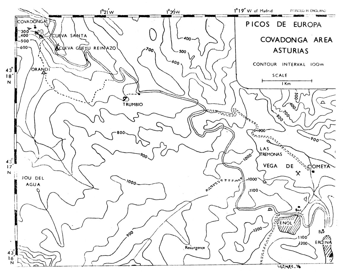
OUCC Proceedings 7 (1975)Covadonga Area |
OUCC Proceedings 7 Contents |
| Cueva de Orandi Cueva la Gueya Reinazo Cueva de la Campaña Cueva Trumbio |
|
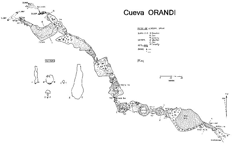
This cave is probably the principal sink for the resurgence at the Cueva Santa at Covadonga. The expedition was by no means the first to visit this impressive and arduous pothole. The first recorded exploration was undertaken by the 1961 Oxford expedition, (ref s. 2 & 3), who reached a reported depth of 75m. The 1972 Oxford expedition revisited the cave, and Orandi has also been explored by Spanish cavers, though to what extent is uncertain.
The cave is situated in a polje approximately 1km south of Covadonga, about 250m above the resurgence cliff. Access is via an old mine track some 3km along the road to Lago Enol; fortunately the track picks an economical route to the polje. The entrance is a large boulder strewn gash in the side of the hill, 20m high and 10m wide, down which a sizable stream disappears.
Some comment on the volume is in order. The resurgence at Covadonga has a total of four exits. In dry conditions, water appears only from the resurgence on the right hand side of the pool, beneath the staircase. As the level builds up, it also appears from two small holes on the left hand side of the cliff. Finally, the writer has observed, in wet conditions, an impressive spout gushing out of the large hole immediately below the chapel in the cliff. On the first visit to Orandi this year, only the first three resurgences were in action at Covadonga, whilst the level of water in the sink was high enough to prevent progress beyond the entrance. On subsequent visits, only the right hand resurgence was producing water. During the 1971 expedition, all four were in operation; unfortunately Orandi was not visited at this time. This leads to two possible conclusions bearing in mind that the gradient of Orandi is such that the water must rise and fall very rapidly. Either the sink is capable of taking so much water that it would be impossible to get into the polje, never mind the cave, or there is another significant feeder somewhere, which enters Orandi below the point of exploration. Either way, the volume of water which has been observed resurging at Covadonga implies that the system has enormous potential capacity.
During the expedition, a total of three trips were made to the cave. In view of the fact that there is a possibility of a sump bypass, it would have been desirable to have sent more parties to the cave. However, Orandi was some 25km from our campsite, and the severity of the system demanded the strongest party we could muster.
The first visit was curtailed by a serious mishap, but would have been abandoned in any case since the water was very high. Because none of the party had been to Orandi before, it was not realised that anything below the third pitch would have been impossible. The party never proceeded past the second pitch, with two exceptions, one on the ladder, the other not. The traverse to the ladder belay is extremely slippery and one of the party did not manage to negotiate it successfully. She was very fortunate to arrive 9m lower down without serious injury. The party retreated, finding the ascent of the first pitch rather more difficult than the descent, and retired thankfully to Lago Enol to look at the scenery.
The second visit found the water very low, and the party proceeded to push down to the sump at -95m. This took about five hours, via six pitches, with a number of optional ones. The optional pitches were in the area below the main pitch, which consists of a large number of steeply sloping, interconnecting potholes. The complexity of this area, 'the Gruyere cheese' can be gauged from the fact that the party managed to split up in pursuit of the sump, and, though one pair waited for the other two, these two, who had also managed to separate themselves, chose routes back which avoided their companions, to the consternation of all involved.
This diversion did have one useful result: the oxbow was discovered by the more static pair. It was decided that, on the surveying trip, one party should be sent to climb the pitch at the end of the oxbow, to see if it was a possible bypass. In the event, the pushing party contrived never to be more than ten minutes in front of the surveyors, and regrettably did not pursue the opportunity presented by the oxbow.
Orandi descends extremely steeply. The passages are relatively wide, even in the Gruyere cheese area, but the amount of flood debris shows that there are few places, if any, where a party could take refuge in the event of flooding. The debris has two side effects: it provides a number of useful logs to aid the descent; and, less, usefully, means that the cave contains an inordinate number of insects.
The first pitch (3m) descends through the waterfall in boulders immediately inside the entrance. When the water is high, this pitch is next to impossible to ascend. A deep pool, the exact depth being determined by the useful expedient of dropping a survey tape onto it, leads to a second waterfall of 9m. A difficult traverse, which requires a fixed line, reaches a large ledge to the left of the water. The second pitch is, in consequence, both free- hanging and dry, and aesthetically very pleasing (8.5m). Below this is a chamber, large in every dimension, most of which is occupied by a deep lake. It is possible to traverse round to the left in boulders, to reach the head of the third pitch (11m). This pitch is wet and drops into another pool, of indeterminate depth since we guarded the tape more carefully at this point. The chamber between the third and fourth pitches.is occupied by this pool; fortunately, there is a large stalagmite column available as a belay for the fourth pitch (20m). This pitch is not aesthetically pleasing. The first five metres are very wet, leading to a greasy ledge, over which one would be well advised to stay on the ladder. Another short vertical drop leads to more substantial slope, equally greasy, before the final vertical section into an oval chamber. A large proportion of the flood debris lands up in this bowl providing both a convenient raft to stand on, out of the water, and a supply of Casteret poles to tackle the next obstacle. The stream sinks beneath the rock wall, the way on being a climb of two metres over a rock buttress. At this point we reached the limit of the exploration by the 1972 party.
Henceforward, the cave becomes extremely complex, with a lot of free-climbing required to negotiate the potholes. From time to time, the route accompanies the stream. Ladders were used in a number of situations, but on the later trip, it was found that only two of these were necessary, one a climb of 3m, the other of 7m. After a long section of potholes, the passage enters a large chamber containing a lake. Beyond this and off to the left is the climb up to the oxbow, whilst the way on with the stream is over a stalagmite flow of approximately 2m height. Another short pothole section leads to a tube, which descends to the stream and the sump. In fact there are a number of routes leading off from the sump in various directions. None of them skirt the sump, which is very definite - a long narrow pool, with a layer of scum on the surface, and extremely uninviting.
It is in the oxbow that the best chance of progress lies. The oxbow is a very high passage, some 30m, leading off at right angles from the streamway, and tending towards a direction parallel to the sump. The passage narrows after 20m and ends at a pitch which has been estimated as 5m. Below this pitch is a pool and the stream can be heard. The oxbow looks to be a promising lead, as the survey illustrates. In the specific context of this area of the cave, it is difficult to know how much further progress could be made before meeting another sump
After the high hopes which the oxbow raised - clearly apparent in Neil's account of the 1973 results - the 1974 expedition was rudely reminded of the example of a well known Iranian cave when another sump was found after two pitches in the oxbow. It appears that an attempt was made to find the depth of the sump by the useful expedient of dropping the survey tape in it before surveying out from the end of the extension. unfortunately, the tape disappeared, the sump didn't and the survey only hopes to obtain grade 1.
Bill Collis
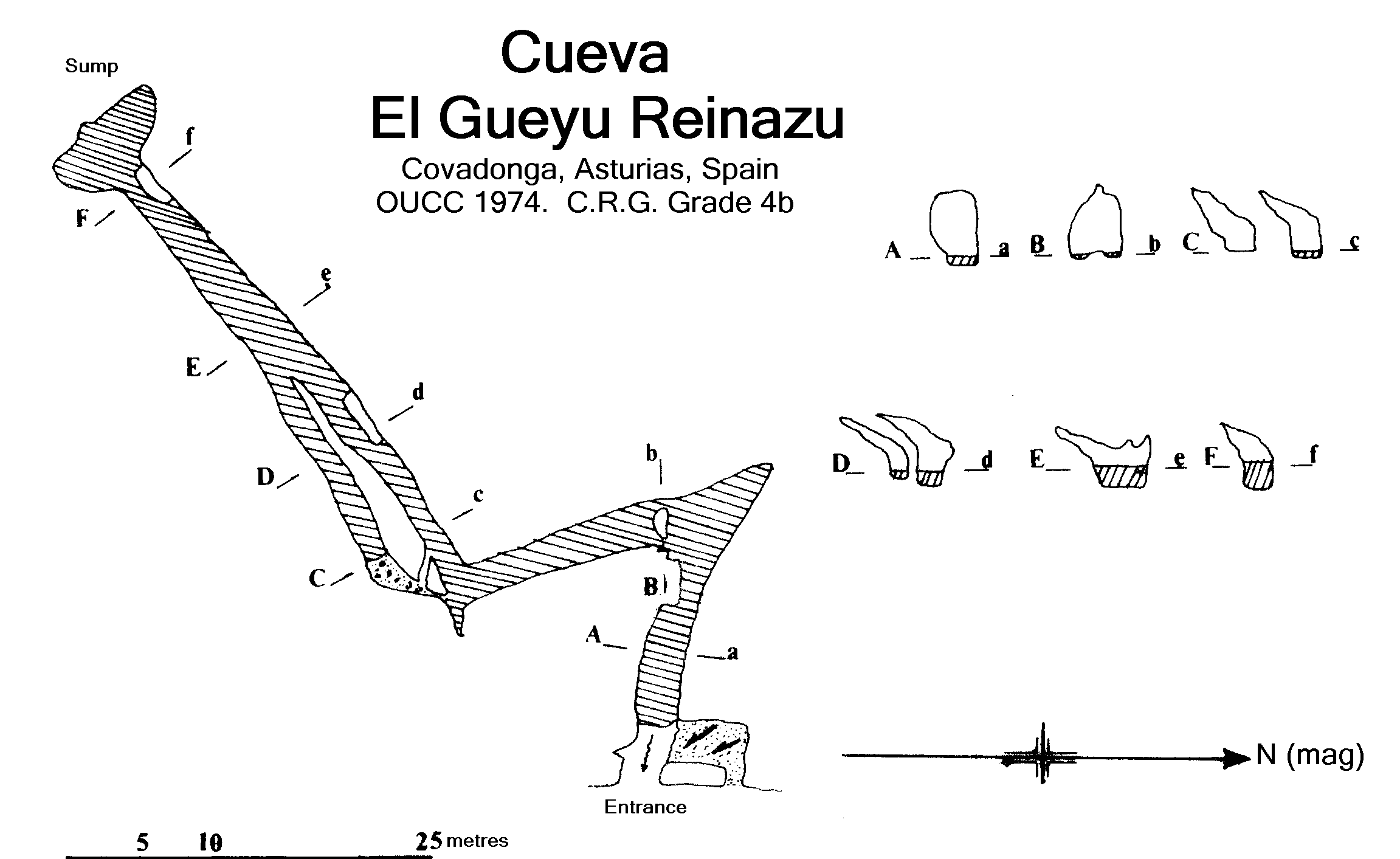
Although only l00m long, this cave was thought to be worth surveying as it may be the resurgence of the Rio de la Mestas which sinks at Orandi. It has been thought that Cueva Santa is the Orandi resurgence, but unlike el Gueyu Reinazo, the water resurging does not correspond to the volume sinking. There is the same slimy deposit on the rock of the cave similar to that found in Orandi. It is nearer to Orandi than Cueva Santa is.
The entrance was shown to us by J.M. (Victor) Victoria of the Barcelona E.S.I.E.C. caving expedition, who confessed it was too cold to explore without wet-suits. It is situated some 500m from Covadonga, 50m from the road where the sound of resurging water can clearly be heard. The swimming and wading required to negotiate the cave is rewarded with a sump after lOOm. It was very cold work surveying; so cold in fact that the possibility of a high level was not investigated.
In 1975 it was found that a French group from the Speleo Club Alpin Languedocien had traced the water to here from Cueva Trumbio in 1964, also taking discharge data at the resurgence.
This is another possible candidate for Orandi's resurgence. Only its entrance 20m from a bar at Covadonga (near a large bell) - has been visited by us but Victor has described some incomplete Spanish exploration of 500m of stream passage, reached via a pitch, which was stopped by a rock barrier at water level which could not be passed except by getting out of the dinghy-so, not having wet-suits ......
The entrance is extensively modified by concrete flooring with an intriguing trap-door, and encumbered with carboys dripping into the water - presumably purifying it. A mossy dry stream course leads down from the entrance which seems to have been a sumped resurgence before being taken over.
Bill Collis
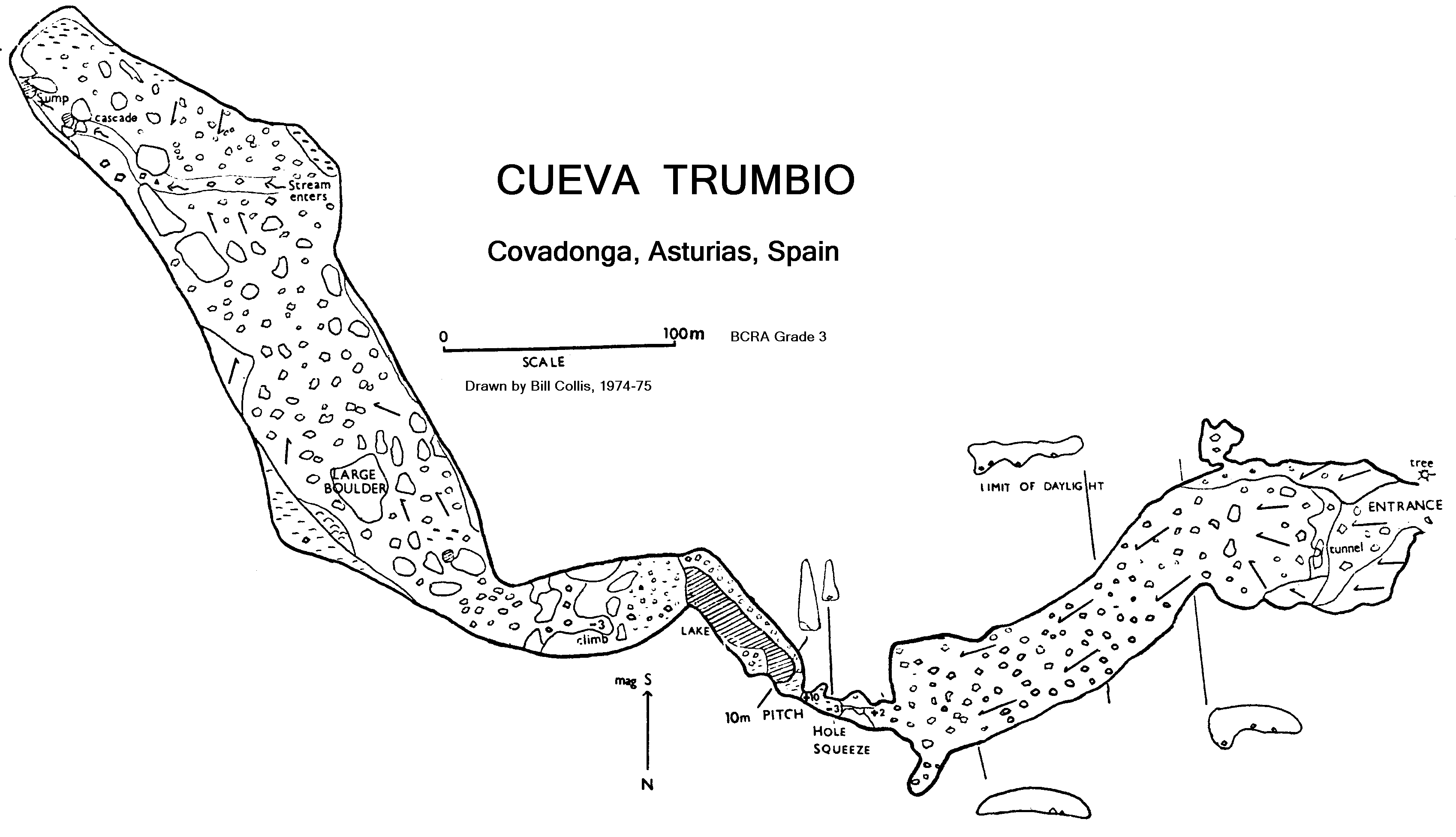
Following the path from the ruin marked on the map as 'El Trumbo' one soon finds a steep blind valley drained by a large dry cave entrance. The bedding plane entrance soon becomes wider and then narrower and higher and after a couple of short drops one reaches a 10m pitch. The cave changes substantially from here, becoming enormous. A stream rises from the boulder floor and echoes throughout the vast chamber. Then the cave abruptly comes to an end and the stream sumps. There are no significant side passages.
This is a very pleasant cave and, although dry, is very clean. It probably takes a stream from the resurgence up the valley in wet weather. The rock is as smooth as marble and as pretty, though there are few formations. In 1975 the French S.C.A.L. group were found to have explored and surveyed Trumbio in 1964 - comparison of surveys showed substantial agreement.