OUCC Proceedings 7 (1975)Area Geology Report 1972-1973N.J. Hancock |
OUCC Proceedings 7 Contents |
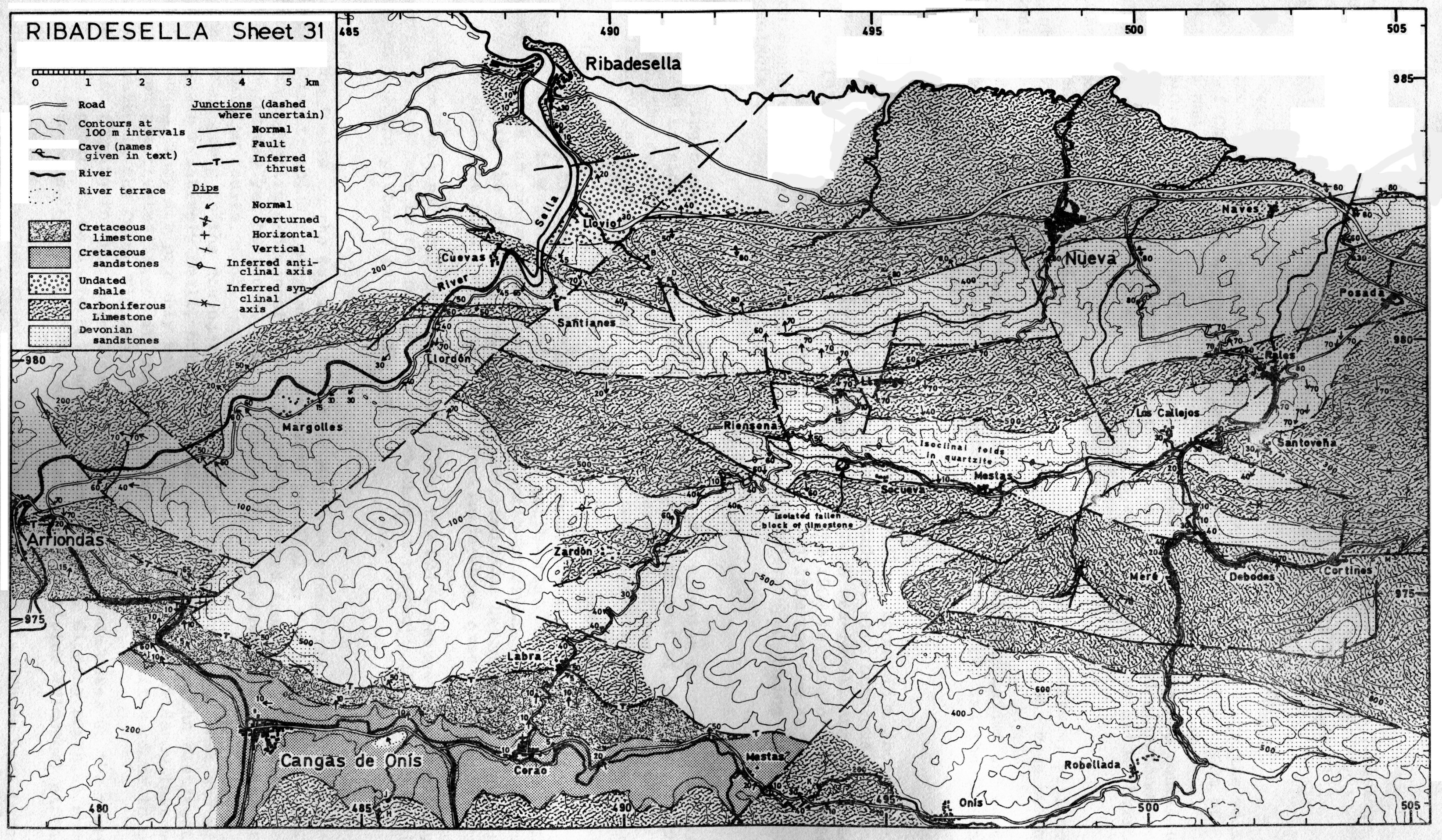
This geological report and map covering sheet No.31 of the 1:50 000 Spanish map is largely based on work done during the O.U.C.C. 1972 expedition to Spain, and published in the report of that expedition (Cox et al 1972). Observations made by various members of the 1973 expedition have been incorporated into the present report, together with fossil determinations which were not available at the time of publication of the previous report. This new information has led to minor revisions to the geological map, which therefore differs from that in Cox et al. (1972). In addition the mapping has been extended further into the unexplored area south of Socueva, Ardisana and Mere.
The following notes describe the rock units which have been recognised, in stratigraphic order.
These rocks include a variety of shallow marine sediments, which are not separated on the map. The thickest sequence occurs north of Riensena, where 1400m of beds are exposed, though the base is not seen. The lower beds include 850m of trough cross-bedded, medium to coarse grained orthoquartzites, overlain by about 100m of laminated shales and siltstones. More cross-bedded quartzites make up the top 450m of the succession. The junction with the overlying limestone is marked by a l-2m bed of red siltstone, which has been recognised near the Cueva Negra, on the col near Cueva Tinganón and at Socueva.
A transitional series of sandstones, shales and limestones 30m thick, overlying at least 100m of quartzite was described to the east by Brooks (1971), but this series is absent in the present area, probably owing to changes in the depositional environment.
Limestone occurs within the sandstones, but it is uncertain at what horizon. On the Ribadesella - Arriondas road near Margolles a bin bed of pure limestone has gradational junctions with sandstone above and below. At Llordon 2100m to the northeast, three similar limestones occur, but these may be the same bed repeated by faults.
Fossils were found by the 1972 expedition at several localities Hancock (in Cox et al. 1972) disproving the belief that the sandstones are unfossiliferous (E.& F. Hernandez-Pacheco 1935). They include plant debris, an orthocone nautiloid and brachiopods. Unfortunately these fossils are poorly preserved and not diagnostic of the age of the beds, but they show that the rocks in future should be carefully examined for further fossils.
The age of the 'Devonian sandstones' remains uncertain, and they have variously been ascribed to the Ordovician, Lower Silurian/Devonian and Carboniferous. The conclusions of the most significant earlier workers ( E. & F. Hernandez-Pacheco 1935, Comte 1959) were discussed by Hancock (in Cox et al. 1972) The brachiopods already found are consistent with a Silurian, Devonian or Carboniferous age, but a Devonian, or possibly the lowest Carboniferous, age is here considered most likely as this is consistent with the locally abundant plant remains. The red siltstone at the top may indicate emergence, so that although there is little or no angular discordance, a period of non-deposition may have preceded the Carboniferous limestone.
In addition to the main development of Devonian sandstone, there is a distinctive unit of brown and dark grey shales, probably about 500m thick, in a small area southeast of Ribadesella, where it is faulted against the Carboniferous limestone. One horizon was found with abundant fossils, chiefly the bivalves Grammatodon (Cosmetodon) sp., Palaeoneibo sp. and a pecten-like form. Very small gastropods are also common, and a kloedenellid ostracod and some plant debris occur. The ostracod restricts the age of this unit to the range mid-Devonian to Carboniferous, but its relation to the normal Devonian sandstones is not known. On the map it is described as 'undated shale'.
This rock is a monotonous pure recrystallised limestone, very dark grey when fresh, weathering to white. It is probably at least 3900m thick, but it appears to be almost devoid of fossils. Boulder beds noted in the Cueva de Tinganón and the Cueva Negra are probably fault breccias.
No evidence was found for the age of the limestone in the present study. Unlike the British Carboniferous limestone, which is Dinantian, this Spanish limestone is widely believed to be of the Namurian (Upper Carboniferous) age (do Sitter 1965) Comte (1329) records Fustitinella bocki (characteristic of the Westphalian) and Marginiferella pusilla in the fault block at Ribadesella.
Cretaceous rocks with a consistent 10 degree dip to the north occupy the valley for 10km east of Cangas de Onis. The lower part of the succession is about 200m of sandstones and siltstones.
A possible basal unconformity has been observed with a fine grained conglomerate lying on the hard Devonian quartzite. Nearby, green sandstones and siltstones contain Gryphaera, a high-spired gastropod encrusted by oysters, and various animal burrows.
The Cretaceous sandstones pass up gradationally into limestone, with some 150m of intermediate calcareous sandstones, in which a small resurgence was seen by the roadside 1km east of Corao.
The limestone may be as much as 150m thick. It is often thin-bedded and somewhat nodular, but like the Carboniferous limestone it lacks fossils, and the two can be extremely difficult to separate.
River terraces occur locally in the Sella valley, about 150m above sea-level. They consist of chaotic piles of large limestone boulders, with numerous cavities between them. Two terrace levels, at 150m and 240m above sea-level, are described by Sanders (1971) around Cortines. It is not clear if the 150m terrace of the Rio Sella, in a wide, open valley, is equivalent to the localised b5Om terrace at Cortines, which Sanders (p.9) rebates to the 10-20m shore-line developed during the last interglacial.
Alternating blocks of Carboniferous limestone and Devonian sandstone, striking east/west and considerably dissected by faulting, make up most of the area. In the north-west, the regional strike changes to north-east/south-west. A broad valley 100-200m above sea-level, occupied by Cretaceous rocks, covers the south of the sheet.
The north of the sheet displays a continuous Devonian to Carboniferous succession which is roughly vertical and youngs northwards. Between Rienseña and Socueva there is an overturned anticline in Devonian sandstones, so that at Rienseña the junction with the overlying limestone is inverted. The Devonian sandstones in the core of the anticline show barge scale isoclinal folds whose axes dip steeply to the south.
The major fault parallel to the Rio Sella and the Rales-Mestas fault truncate the Palaeozoic structure to the north-west and south-east respectively and completely different folding patterns take over.
The faults on the map fall into four distinct categories. The first are the strike faults, trending approximately east/west parallel to the bedding. They are difficult to recognize and cannot always be distinguished from normal junctions; more of these faults may yet be found. They are the earliest, because they are offset by all the remaining faults.
The second group Is the conjugate set of faults trending some 300 east and west of north. They are relatively small, but in several places they offset the east/west mountain ranges. They are probably Hercynian in age, but there is evidence that some may have been reactivated later, in the form of realigned stalactites close to one of these faults in Cueva Tinganón.
The fault forming the northern limit of the Cretaceous beds makes up the third category. It appears to be a steep thrust, or reverse fault, dipping north at about 45 degrees It is post--Cretaceous, and is probably associated with the Alpine (Miocene) earth movements.
Finally there are two important north-east/south-west faults. These were both active at the latest stage of all, as they affect the Cretaceous outcrop. However, because of the change in style of the Paleozoic structures across them, they must also be associated with the Hercynian deformation. These are major dislocations, probably active over a long period.
In the previous report (Hancock in Cox et al. 1972), important differences were noted between the present area, the adjoining area to the east mapped by Brooks (1971 and areas further to the east (Bertrand & Mengaud 1912). It was concluded that many of the differences are probably explicable in terms of faults similar to the north-east/south-west faults described above.
Bertrand, L. & L.Mengaud 1912. Sur la structure des Pyrenees Cantabriques entre Santander et Llanes et leurs relation probables avec les Pyrenees. Bull. Soc. Geol. France (ser.4) XII, 504-518
Brooks, A.G. 1971. Geological report. in Caves of the Western Sierra de Cuera, ed. G.C. Cox. Trans Cave Res. Gp. of GB 13, 1-35
Cox, G.C., Hancock N.J., J. Davies & A.G. Brooks 1972. Oxford University Cave Club Expedition to Northern Spain 1972 Report. Westminster Speleological Group Bull. 7.(12)
Comte, P. 1959. Recherches sur les terrains anciens de ba Cordillere Cantabrique. Mems. Inst. Geol. Min Esp. 60, 1-440
De Sitter, L.U. 1965. Hercynian and Alpine orogenies in Northern Spain. Geologie Mijnb. 44, 373-383
Hernandez-Pacheco, E. & F. Hernandez-Pacheco 1935. Observaciones respecto a estratigrafia tectonica de la Cordibbera Cantabro-asturiana. Bol. R. Soc. Esp. Hist. Nat. XXXV 487-499
Sanders, F.E.T. 1971. Hydrological report in caves of the Western Sierra de Cuera, ed. G.C. Cox. Trans Cave Res. Gp. of GB. 13, 1-35