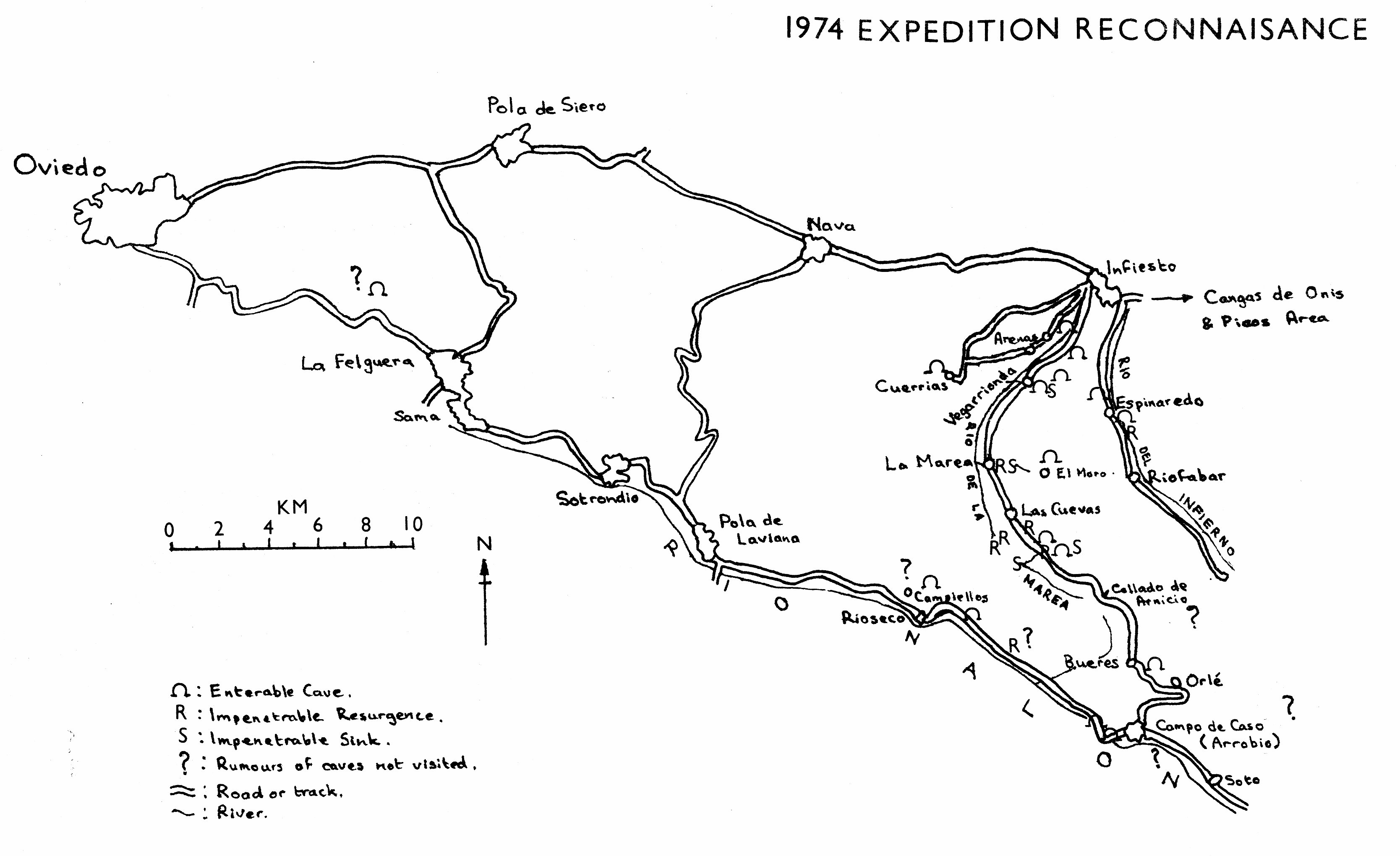
- The Nature and Extent of
Exploration in 1974 - Map
- General Geological Background
- Espinaredo
- Infiesto
- Vegaredonda
- La Marea
- Las Cuevas
- Arnicio to Campo
- Campo to Felguera
- Conclusions
OUCC Proceedings 7 (1975)Infiesto - Campo de Caso - Oviedo Area |
OUCC Proceedings 7 Contents |
Martin Laverty
|
|
The geographical area which the 1974 expedition set out to explore for two weeks can best be described as a 20km x 20km area south-west of Infiesto, a moderately large retail and administrative centre with some food processing industries. The north, west and south sides are defined by quite good, metalled roads and the east side by the gravel surfaced road to Campo de Caso. We camped in a field several hundred yards south of the hamlet of Las Cuevas, only yards from the source of the Rio de La Marea which flows down to Infiesto. We drove around the perimeter of the area and tried to find out about cave locations both by direct observation and by asking local inhabitants, mainly ensconced in bars. Our original intention of a fairly mobile, wide ranging thorough reconnaissance of the area was largely foiled by punctures and a burst tyre which necessitated importing a replacement from England later on in the expedition - future expeditions should note that while the Spanish Seat automobile company are related to the Italian Fiat company, the vehicles they produce bear little resemblance in details - No Spanish. garage stocked tyres suitable for a Fiat 500. In addition, the area has quite a high relief, is, as is usual in the Cantabrians, heavily vegetated and, at least when we were there, is very warm. These factors severely curtailed plans to explore on foot.
In view of all this, the valley of the Rio de la Marea from Infiesto to the Collado de Arnicio (908m) was thoroughly explored while the valley of the Rio Nalon from Campo de Caso to just beyond the iron, steel and coal-mining centre of La Felguera was explored less thoroughly, although a group of young Spanish cavers from this town accompanied us on several visits to Rioseco, where they showed us some well known caves.
1:50,000 Rioseco sheet covers most of the area and shows the rocks to be of mainly Carboniferous and Cretaceous ages. The lithology falls into three broad categories: limestones, sandstones and shales. The shales and some limestones are fossiliferous, one bed of shale near Vegarrionda yielding numerous trilobites, brachiopods and corals. Some plant remains were also found in a different location. In the Nalon valley there are several coal mines and mineral exploitation has been carried out in several other areas. A mine well known to the locals at Vegarrionda for its coloured 'rocas preciosas' evidently had been used to mine copper ore, partly by open cast and partly by adit mining. The structure is very complex, with extensive folding and faulting leading to the rocks over much of the area being vertically bedded, although the limestone just south of Infiesto (just off the Rioseco sheet) dips at only a small angle.
These are generally described in a cyclic geographical manner starting from Infiesto and travelling clockwise round to Campo de Caso, La Felguera and thence back to Infiesto.
From Infiesto, a valley leads south, parallel to the valley of the Rio de la Marea which leads to Campo, into the mountains. About a mile before the fairly large village of Espinaredo there is a small cliff on the right hand (W) side of the road with a fair sized stream emerging from a small entrance (2ft high by 4ft wide). The cave was followed for an estimated 400m to a sump, the passage being generally low and always with a stream. There was one side- passage which was not followed because it appeared to be largely filled with foam - and besides, it was raining outside. The owner of the bar told us that a local Count (?) had explored this cave. Just beyond the village another band of vertical limestone is crossed. Several entrances were observed, one especially intriguing one being gated for water supply and apparently being the resurgence of a fairly sizable stream. Beyond, the track climbs into an impressive wild, wooded country based on sandstone but an impressive gorge in limestone could be seen ahead, although it appeared inaccessible except by several hours hard slog on foot
After passing out of Infiesto by the station a road to the right announces the Cueva de la Virgen. Here, the fossiliferous limestone is more or less horizontal but it is not at all clear whether the 'cave' is of speleological interest or not. It seems quite possible that it is just a large undercut in the cliff related to the river which is over 2m deep and is a very popular bathing place. The chapel built into the cliff did not encourage us to explore further
The next turning to the right was sign-posted to Las Arenas It leads eventually to an isolated limestone block at Cuerrias. Here, a resurgence cave, the Cueva de las Xanas, was explored in boots and shorts for about 40 uncomfortable metres. The stream was cold and the passage low and gravel floored, with occasional avens containing loosely cemented fill and old flowstone. The passage continued - clean washed and low - but we did not. It is interesting that this cave seemed to be heading away from the surface exposure so how it acquires its stream is uncertain. We were informed of another cave in the area - Cueva de los Moros - but could find no trace of it in the heavily wooded valley we were directed to.
Returning to the Infiesto - Campo road, there is a prominent undercut cliff on the left hand side of the road and a small stream sinks here, although the main river is close by across the road. The track to the left leads to a hamlet where a farmer took great pleasure in showing us a cave which he had explored. This turned out to be a fairly pleasant cave extending under a knoll for about l30m,containing a stream throughout and two drops in level of about 2m. The stream emerges from a short bedding plane section of cave ( 5m inclined at 200) into a depression evidently formed by collapse of the surface. Quite a few small entrances are to be found and the stream sinks in one which is choked with debris. A tight squeeze (possibly not very tight if a tree-trunk is extracted) leads into an awkward passage which leads to the head of the first drop of floor level where the stream enters from another passage which can be followed for about loin until it gets too tight. The stream passage from the bottom of this chamber entails crawling in water and forks, one way leading to a sump and the other rejoining this passage after its phreatic interlude. Another wide chamber is encountered at the second drop of passage level and the lower entrance entails climbing down a greasy 2m waterfall. The stream almost immediately sinks into another cave passage which starts as a high rift and soon becomes too low to follow. Walking on the surface reveals a large number of other sections of this stream interspersed with short sections of cave passage, some enterable and others not.
Here, a track to the left leads to the village of San Martin. A stream resurges from a swap in a short cave between a bridge over a dry stream course and the village of Vegarrionda, the stream having sunk in one of several debris choked rifts maybe a hundred metres further up the valley. We were directed to a large chamber high on a hillside behind San Martin which was located by the presence of a nearby tree and the entrance was unstable. We had been told that there was a very deep shaft there as well but this was not found. Several water troughs bore crests which were evidently related to local mining activity and several mined passages were investigated in the area with the hope that they led to natural passages - although the ones we saw did not.
Beyond La Marea - the furthest point of call of both the Infiesto bus and wine lorry-a tributary stream passes through a deep gorge in the limestone on its way to the river. A track to the left climbs up to this and the stream can be reached by climbing down a steep boulder slope. The stream passes perpendicularly across the strike of the bed of vertical limestone about 200m thick and it is interesting to see the stream passing here from surface to underground flow. About 2/3 of the water seemed to pass into a cave via a swap which poking about showed to be blocked to all intents and purposes by mud- covered debris, the other 1/3 following the surface stream course until it was rejoined by the original water emerging once again, from a swap. A very narrow rift, too constricted to allow entry, gave access to the intermediate cave stream about 30m away from this resurgence.
This village, which does not even have its own bar, did not appear to have large caves associated with it, despite one road map which indicated that it (lid. Several large phreatic tubes are visible high on the limestone ridge to the left of the road but in fact only go in for about 20m and the ridges are quite narrow anyway. The villagers took us to one quite well decorated cave called El Venero about 2km south of the village and reached by an awkward climb up a steep hillside and through several bushes. This cave has a large entrance and a large chamber reached through a squeeze and was said to have had another entrance on the other side of the ridge until a few years ago. Many villagers seemed to delight in recounting their adventures in this cave to each other and the stal. ornamenting at least one village wall is probably from here. Much more interesting to us was the Cueva del Rio, a cave reached by walking up the valley which the road crosses by a bridge, and climbing a couple of mossy cascades to an impressive flat, gravel-floored gorge about 2m wide. This leads to a cliff in which there are two main cave entrances. One, reached by climbing a slope at the base of the cliff gives access to a passage emerging on a sloping shelf about loin above the floor of the other, which itself is reached by climbing what, with a stream, must be a very sporting cascade. The cave reached is most impressive - perhaps 20m high l-2m wide and containing deep2 water filled potholes. The upward gradient steepens and daylight is reached round a corner where a large boulder fall must be climbed to emerge on the surface. Whether the large passage continues on the other side of the boulders we do not know but possibly there is some way through which we did not find. Following a dry stream bed upwards, one comes to the stream sinking down a debris choked passage but there are some tight phreatic tubes just down from the sink which provide a short through trip. The water (presumably the same, although we did not test it) emerges from a small hole blocked by a boulder several metres above the level of the surface stream near the road and can be heard from the road falling down the stream bed.
Another resurgence in a side valley to the left of the Infiesto-Campo road was found nearer Las Cuevas but was, again, too small to allow access. These tributaries joined the stream in the main valley, the Rio de la Marea, and this sank over a short distance to leave a dry stream bed for several kilometres until it resurged just above our campsite, again amidst the rocks of its bed. It was also augmented here by several resurgences on the other (W) side of its course - presumably from the other side of the valley.
Limestone is again seen, after several miles of sandstones and shales, at Collado de Arnicio, from which there is a splendid view south on a clear day. However, no cave entrances were obvious and enquiry at the village of Bueres only produced an old dry cave filled with powdery stal. which, although quite large in places, had all ways on blocked by stones or stal. and only amounted to about 20m in total. This was situated just over the second bridge from the village on the road to Campo. We were also told of some caves at Orlè, these caves being supposedly about an hours walk along a track leading south- east from the village, but we did not have time to investigate further.
In Campo we were told of a large chamber which could be reached by climbing about 5m down the side of the gorge which the road to Soto de Caso passes spectacularly through. We did not succeed in finding this cave, but were very impressed by the gorge which is nearly vertical on each side with the Rio Nalon flowing through it. Various entrances could be observed on the far side, but these would be extremely difficult to reach
About 2km out of Campo on the road to Oviedo the most spectacular Cueva Deboyo (alternative name - Cueva del Bollo) passes by the road which crosses a bridge over the Rio Nalon before it is engulfed it this large entrance. Again, various factors prevented our examination of the interior of this cave, but its resurgence from an equally impressive orifice is to be found only slightly further along the road. There are several large rock shelters above the level of this cave, only cursorily examined but not appearing to 'go'. The limestone in which the holes can sometimes be seen in the cliffed sides of the rivers gorge is left before Coballes but sonic more is crossed in the area in which a large H.E.P. scheme is being constructed. A large dam is to be built across the Nalon and an underground tunnel is being built - the adits leading to this were last year mistaken by us for a large and prosperous mining activity. There is an intriguing resurgence from a man-made, gated hole in the side of the wall, the opening of the door revealing a very wet pitch going down to river level and the water entering via a narrow tube. A construction worker coming to collect some drinking water here informed us of a deep pot on the hillside above ( not located) and a large cave entrance by the roadside several kilometres beyond Rioseco- the Cueva del Condillo. This cave was entered and led to two static swaps, which sometimes appeared to become active judging by the evidence of a stream from one to the other, these being in a large widened rift passage maybe 10m high and sloping at about 300 to vertical. A small passage also ascended steeply and was shown to us by three Spanish boys from La Felguera whom we met inside. These boys later showed us some caves near Rioseco, where a dry valley runs up from the village towards the watershed between the Nalon and La Marea rivers. Several cave entrances were visible in the luxuriant undergrowth but we were only able to explore the Cueva de Maria- Suarez - well known to local inhabitants despite its position about half way up the valley side,which required a rather uncomfortable trek and climb to reach. This cave was followed for several hundred metres and was not completely explored, although there was evidence of many others having been there. The first part is dry, muddy, large and has been very well decorated with stal. Evidence of old water levels is shown by mud deposits on walls and ~ couple of metres of static 2m deep water separates this from the next part of the cave, which is again dry, fairly large, muddy and decorated. Holes in the floor indicated extensions to a lower level but were not followed.
There is also limestone which contains caves, although their size is unknown to us, between La Felguera and Oviedo. Our La Felguera friends showed us one 4Oft shaft possibly with passages at the bottom but this could not be descended at the time since it emerged a ladder was needed, contrary to what we had been led to expect.
It is evident from the preceding account that little was found of any great interest to the sporting caver. However, as is also evident, many areas were ignored away from the main roads, which are possibly the areas with more potential - higher altitude and, in certain cases identifiable on a reliable geological map, runoff from the impermeable rocks onto exposed limestones. Certainly, we found nothing which could prohibit the finding of large systems here in future - even the narrow vertical ridges of limestone could have linear caves of considerable length ( the Rales Cave is in such a situation for example) and it seems that there are also larger blocks of limestone in the interior. The area would seem to deserve some more attention in the future but the work may have to be rather painstaking - rather more so than any British expeditions to Spain that I know of have managed to sustain for very long.