OUCC Proceedings 7 (1975)Edited by Martin Laverty Contents |
OUCC Home Page
|
The figures given after cave names are the Grid references to the 1:50,000 Edición Militar (Lambert grid references) followed by the altitude of the entrance in metres.
It is only just over a year since Proc. O.U.C.C. 6 emerged, having been delayed for 2-3 years. This issue was not envisaged for some years since the 1973 expedition results were supposed to be published by the Oxford University Exploration Club because of a University rule governing expeditions awarded university money. However, by the summer of 1975 the O.U. Exploration Club finally decided that they could not produce the report - having kept it hanging about for over a year, and gave us back the original money set for a report in the expedition accounts.
Results from expeditions in 1974 and 1975 have generally been incorporated with the original reports from 1973 where appropriate and so I hope the distinctive approaches of the different writers have not been altered too much by the editing which has been necessary.
No reports on any other club activities have been included since they generally amount to only routine sporting trips during the term and Christmas and Easter vacations. Lack of keen car-owning cavers precludes such work as digging because of the transport difficulties. The only other noteworthy trip undertaken by any members was a trip to the Chourun des Aiguilles with a group from Derbyshire led by Clive Westlake of the Eldon P.C. which two members participated in - one getting to the bottom, the other retiring injured with a severely gashed hand. This has been reported in Descent and the Journal of the Burnley Caving Club (N. Smith 1975), as well as by Clive Westlake in a B.C.R.A. Bulletin.
N.S.Boulton Queen's College Leader & surveyor
R.B.Willis Exeter College Treasurer
C.C.Cox ex Dept Botany & Leeds Univ. Surveyor & Photographer
W.J.M.F.Collis Balliol College Medical Supplies
J.Forder ex Corpus Christi College
P.J.Friend Hertford College
M.Laverty Brasenose College Surveyor & Report Editor
M.A.Morrison Lady Margaret Hall
P.G.Urben ex St. Catherines Coll.& Durham Univ.
J.Wild Leeds Univ.
The expedition had three basic objectives before it. The first was to continue the successful series of O.U. Cave Club expeditions to Northern Spain. Second, the main work of the expedition was to explore and survey a number of cave systems which had been located by the 1972 reconnaissance expedition (Ref.1) in the area of the Cantabrians between the rivers Cabras and Sella. Finally, it was our intention to investigate the more promising limestone blocks of the area for further cave systems to increase the knowledge, from a Speleological point of view, of a little known limestone region.
The original plan had been to take two vehicles, a Land Rover, bought with the aid of a loan from the Clubs' Committee, and a Citroen, belonging to one of the members of the expedition. This was felt to be necessary to transport the large amount of impedimenta which burdens a caving expedition, and also to give a certain amount of flexibility to a party whose average size at any one time was eight. In the event, it proved to be impossible to raise the amount of money required to insure and maintain a Land Rover, so we were wholly dependent on the Citroen and a trailer, which the club possessed as a result of irretrievable breakdown on a previous expedition. Four members of the expedition travelled independently, either by air and train, or via the Southampton-Bilbao ferry.
The main body of the expedition left Oxford on July 4th and reached Llanes on July 6th, having a relatively trouble free journey. It was decided to set up camp at Rales, a village 3km south of Posada, since it was close to Llanes, the market town for the area, and offered a cave within walking distance. No other site could be found which presented these advantages, and the decision was ultimately vindicated by the amount of exploration which the caves of Rales demanded.
Arrangements were made with the owners of the village bar for the use of a field next to the river as a campsite, and for a power point in the bar from which to charge caving lamps. We used Rales as the base of the expedition throughout.
John Forder and Peter Urben arrived on July 10th, Bill Collis on July 18th (though due to mismanagement we did not make contact until two days later) and Robin Willis appeared on July 26th. The caving effort of the expedition breaks down as follows:
Rales area 18 trips
Mestas area 5 trips
Covadonga area 3 trips
Lledales 2 trips
Llovio area 2 trips
Villa area 2 trips
Some time was also devoted to investigating other possible sites, particularly in the vicinity of Rales where we were shown numerous small holes. Towards the end of the expedition we visited an area between Infiesto and Campo de Caso, which had not been explored. Several caves were observed and plans were made to return to the valley to make a fuller reconnaissance.
As in previous years we were immediately assisted by the local villagers, who took considerable interest> in the work we were doing. Indeed, by the end of the expedition, we were being informed of the whereabouts of new holes almost daily.
M. Laverty Brasenose College Leader
N.I.Coghlan Queens College Secretary
B.Matthews Worcester College
J.Kirby Wolfson College
W.J.M.F.Collis Balliol College Treasurer
R.B.Willis Dept. of Astrophysics
N.S.Boulton ex Queens College
J.Forder ex Corpus Christi College
J.G.Sheppard ex Magdalen College
The first three above named members left Southampton via the San Sebastian ferry on 29th July, travelling in a rather overcrowded Fiat and taking advantage of the last day of low season fares. They arrived on 1st July and proceeded straightaway towards Infiesto, where they arrived the following day. A campsite was pointed out by the villagers of Las Cuevas in a flat field by a pleasant stream which resurged from various impenetrable springs about 50m away and this was used until 14th July while the area between Campo de Caso and Infiesto was investigated as well as possible in view of certain difficulties encountered with the car.
The fourth expedition member arrived by student flight to Bilbao followed by coach to Infiesto on 3rd July. Several trips were made to the area between Campo de Caso and Oviedo to follow up possible leads given us by a group of Spanish boys we met in a cave and who lived in La Felguera, a heavily polluted steel-working and coal-mining town,and there was a rest day when Leon was visited. Bill Collis arrived via the Santander ferry on a motorbike on 14th July and helped with the following day's change of campsite to the venue of the 1973 expedition - Rales. On 17th and 18th July the last four members of the expedition joined us here, John Forder and Jim Sheppard having crossed the channel ferry and driven through France while Neil Boulton and Robin Willis had come by the Santander ferry. Photographic, sporting and a few attempted pushing trips were made in the Rales Cave System and the cars were used to reach Cueva Orandi, which was to be pushed, and to visit the Picos via the Fuente De cable car, in the course of which trip we were told of some caves near Panes, which were investigated later but unfortunately led nowhere, despite the efforts of pyromaniac shepherds in removing vegetational obstructions to entrances.
Martin Laverty and Nick Coghlan left for an expedition to the Chourun des Aiguilles in France on 25th July while Brian Matthews and Jenny Kirby left for home by air on 28th July. The remaining five pushed Orandi, although the results were not as spectacular as those hoped for, and discovered Cueva Trumbio nearby. Little more was found during the rest of the expedition, which broke up when Robin Willis, Neil Boulton and Jim Sheppard came home on 10th August, the remaining two staying in Spain for some weeks more and making useful contacts with a Spanish caving group (ESIEC), exploring and surveying.
No official 0.U.C.C. expedition took place in 1975 after a lack of interest following the breakdown of plans for an expedition to Poland, by which time permits for a serious caving expedition would have been difficult to obtain anyway. Bill Collis - a well-known Hispanophile - arranged an expedition around a walking holiday for some members of the Oxford University Rambling Club. Three cavers also went and investigated some entrances, met other caving expeditions, drank, ate and lazed about - but not necessarily in that order.. There were two 0.U.C.C. members: Bill Collis and Martin Laverty; Mike Cowlishaw of B.E.C. and Steve Newton, another Oxford undergraduate, who had been persuaded to take a car and take up caving by Bill. The ramblers also became interested in caving and found some possible entrances which may be investigated in an expedition in 1976. Only results which are complete or relevant to previous work have been reported in the hope that 1976 will produce enough results for a report of its own based on reconnaissance in 1975. One very interesting possibility for the future is the - at present 350m deep and 2km long Pozo de Vega el Forcau which has been partially explored by E.S.I.E.C. a Barcelona caving group and has its entrance at about 1,470m in the Western Massif of the Picos de Europa. 1975 Report.
The 1973 expedition wishes to thank the Gilchrist Educational Trust and the Spalding Trust for financial support, and the Oxford University Expedition Council for their advice and generous donation. We also acknowledge all those who helped the expedition personally, especially the Cave Research Group of Great Britain, Dr. M. Sweeting as our home agent, Dr. A. Colson for generous encouragement.
Individual members of all expeditions wish to thank the A.C. Irving Memorial Trust for its financial assistance and the grants from Brasenose (1973 & 1974), Wolfson(1974) and Worcester (1974) to expedition members are also gratefully acknowledged.
All expeditions are especially grateful to Dr. Juel-Jensen for medical advice and supplies and to the B.C.R.A. for approval of our plans.
We also wish to thank the Expedition Council for extra money to offset rises in publication costs since 1973 and the Clarendon Laboratory for reducing surveys
Thanks to Miss D. Toft for typing and allowing spelling and punctuation mistakes.
Last, but by no means least, we thank the people we met in Spain for making our stays so enjoyable, the people of Rales being especially thanked for allowing us to stay for three successive years.
This geological report and map covering sheet No.31 of the 1:50 000 Spanish map is largely based on work done during the O.U.C.C. 1972 expedition to Spain, and published in the report of that expedition (Cox et al 1972). Observations made by various members of the 1973 expedition have been incorporated into the present report, together with fossil determinations which were not available at the time of publication of the previous report. This new information has led to minor revisions to the geological map, which therefore differs from that in Cox et al. (1972). In addition the mapping has been extended further into the unexplored area south of Socueva, Ardisana and Mere.
The following notes describe the rock units which have been recognised, in stratigraphic order.
These rocks include a variety of shallow marine sediments, which are not separated on the map. The thickest sequence occurs north of Riensena, where 1400m of beds are exposed, though the base is not seen. The lower beds include 850m of trough cross-bedded, medium to coarse grained orthoquartzites, overlain by about 100m of laminated shales and siltstones. More cross-bedded quartzites make up the top 450m of the succession. The junction with the overlying limestone is marked by a l-2m bed of red siltstone, which has been recognised near the Cueva Negra, on the col near Cueva Tinganón and at Socueva.
A transitional series of sandstones, shales and limestones 3Om thick, overlying at least 100m of quartzite was described to the east by Brooks (1971), but this series is absent in the present area, probably owing to changes in the depositional environment.
Limestone occurs within the sandstones, but it is uncertain at what horizon. On the Ribadesella - Arriondas road near Margolles a bin bed of pure limestone has gradational junctions with sandstone above and below. At Llordon 2100m to the northeast, three similar limestones occur, but these may be the same bed repeated by faults.
Fossils were found by the 1972 expedition at several localities Hancock (in Cox et al. 1972) disproving the belief that the sandstones are unfossiliferous (E.& F. Hernandez-Pacheco 1935). They include plant debris, an orthocone nautiloid and brachiopods. Unfortunately these fossils are poorly preserved and not diagnostic of the age of the beds, but they show that the rocks in future should be carefully examined for further fossils.
The age of the 'Devonian sandstones' remains uncertain, and they have variously been ascribed to the Ordovician, Lower Silurian/Devonian and Carboniferous. The conclusions of the most significant earlier workers ( E. & F. Hernandez-Pacheco 1935, Comte 1959) were discussed by Hancock (in Cox et al. 1972) The brachiopods already found are consistent with a Silurian, Devonian or Carboniferous age, but a Devonian, or possibly the lowest Carboniferous, age is here considered most likely as this is consistent with the locally abundant plant remains. The red siltstone at the top may indicate emergence, so that although there is little or no angular discordance, a period of non-deposition may have preceded the Carboniferous limestone.
In addition to the main development of Devonian sandstone, there is a distinctive unit of brown and dark grey shales, probably about 500m thick, in a small area southeast of Ribadesella, where it is faulted against the Carboniferous limestone. One horizon was found with abundant fossils, chiefly the bivalves Grammatodon (Cosmetodon) sp~., Palaeoneibo sp. and a pecten-like form. Very small gastropods are also common, and a kboedenellid ostracod and some plant debris occur. The ostracod restricts the age of this unit to the range mid-Devonian to Carboniferous, but its relation to the normal Devonian sandstones is not known. On the map it is described as 'undated shale'.
This rock is a monotonous pure recrystallised limestone, very dark grey when fresh, weathering to white. It is probably at least 3900m thick, but it appears to be almost devoid of fossils. Boulder beds noted in the Cueva de Tinganón and the Cueva Negra are probably fault breccias.
No evidence was found for the age of the limestone in the present study. Unlike the British Carboniferous limestone, which is Dinantian, this Spanish limestone is widely believed to be of the Namurian (Upper Carboniferous) age (do Sitter 1965) Comte (1329) records Fustitinella bocki (characteristic of the Westphalian) and Marginiferella pusilla in the fault block at Ribadesella.
Cretaceous rocks with a consistent 10 degree dip to the north occupy the valley for 10km east of Cangas de Onis. The lower part of the succession is about 200m of sandstones and siltstones.
A possible basal unconformity has been observed with a fine grained conglomerate lying on the hard Devonian quartzite. Nearby, green sandstones and siltstones contain Gryphaera, a high-spired gastropod encrusted by oysters, and various animal burrows.
The Cretaceous sandstones pass up gradationally into limestone, with some 150m of intermediate calcareous sandstones, in which a small resurgence was seen by the roadside 1km east of Corao.
The limestone may be as much as 150m thick. It is often thin-bedded and somewhat nodular, but like the Carboniferous limestone it lacks fossils, and the two can be extremely difficult to separate.
River terraces occur locally in the Sella valley, about 150m above sea-level. They consist of chaotic piles of large limestone boulders, with numerous cavities between them. Two terrace levels, at 150m and 240m above sea-level, are described by Sanders (1971) around Cortines. It is not clear if the 150m terrace of the Rio Sella, in a wide, open valley, is equivalent to the localised b5Om terrace at Cortines, which Sanders (p.9) rebates to the 10-20m shore-line developed during the last interglacial.
Alternating blocks of Carboniferous limestone and Devonian sandstone, striking east/west and considerably dissected by faulting, make up most of the area. In the north-west, the regional strike changes to north-east/south-west. A broad valley 100-200m above sea-level, occupied by Cretaceous rocks, covers the south of the sheet.
The north of the sheet displays a continuous Devonian to Carboniferous succession which is roughly vertical and youngs northwards. Between Rienseña and Socueva there is an overturned anticline in Devonian sandstones, so that at Rienseña the junction with the overlying limestone is inverted. The Devonian sandstones in the core of the anticline show barge scale isoclinal folds whose axes dip steeply to the south.
The major fault parallel to the Rio Sella and the Rales-Mestas fault truncate the Palaeozoic structure to the north-west and south-east respectively and completely different folding patterns take over.
The faults on the map fall into four distinct categories. The first are the strike faults, trending approximately east/west parallel to the bedding. They are difficult to recognize and cannot always be distinguished from normal junctions; more of these faults may yet be found. They are the earliest, because they are offset by all the remaining faults.
The second group Is the conjugate set of faults trending some 300 east and west of north. They are relatively small, but in several places they offset the east/west mountain ranges. They are probably Hercynian in age, but there is evidence that some may have been reactivated later, in the form of realigned stalactites close to one of these faults in Cueva Tinganón.
The fault forming the northern limit of the Cretaceous beds makes up the third category. It appears to be a steep thrust, or reverse fault, dipping north at about 45 degrees It is post--Cretaceous, and is probably associated with the Alpine (Miocene) earth movements.
Finally there are two important north-east/south-west faults. These were both active at the latest stage of all, as they affect the Cretaceous outcrop. However, because of the change in style of the Paleozoic structures across them, they must also be associated with the Hercynian deformation. These are major dislocations, probably active over a long period.
In the previous report (Hancock in Cox et al. 1972), important differences were noted between the present area, the adjoining area to the east mapped by Brooks (1971 and areas further to the east (Bertrand & Mengaud 1912). It was concluded that many of the differences are probably explicable in terms of faults similar to the north-east/south-west faults described above.
Bertrand, L. & L.Mengaud 1912. Sur la structure des Pyrenees Cantabriques entre Santander et Llanes et leurs relation probables avec les Pyrenees. Bull. Soc. Geol. France (ser.4) XII, 504-518
Brooks, A.G. 1971. Geological report. in Caves of the Western Sierra de Cuera, ed. G.C. Cox. Trans Cave Res. Gp. of GB 13, 1-35
Cox G.C., Hancock N.J., J. Davies & A.G. Brooks 1972. Oxford University Cave Club Expedition to Northern Soain 1972 Report. Westminster Speleological Group Bull. 7.(12)
Comte, P. 1959. Recherches sur les terrains anciens de ba Cordillere Cantabrique. Mems. Inst. Geol. Min Esp. 60, 1-440
De Sitter, L.U. 1965. Hercynian and Alpine orogenies in Northern Spain. Geologie Mijnb. 44, 373-383
Hernandez-Pacheco, E. & F. Hernandez-Pacheco 1935. Observaciones respecto a estratigrafia tectonica de la Cordibbera Cantabro-asturiana. Bol. R. Soc. Esp. Hist. Nat. XXXV 487-499
Sanders, F.E.T. 1971. Hydrological report in caves of the Western Sierra de Cuera, ed. G.C. Cox. Trans Cave Res. Gp. of GB. 13, 1-35
The prominent entrance of the Cueva de la Fuentica has a small stream course running up to it but the water sank about 50m away higher up the polje. In the past, however, water has cut a distinct trench through a rim of rock at the entrance, inside which is a barge chamber from which several routes head to the streamway and upper levels of the cave. On the right hand (E) side of the chamber is another chamber with a floor level several metres higher which has been formed by extensive collapse from the roof. Another chamber, this time sloping at an appreciable angle and, again,formed by collapse of the roof, can be reached by climbing several metres up the steep earthy slope outside the main entrance.
The passage originally used by us to reach the streamway is a generally high, narrow passage heading off from the far right hand corner of the entrance chamber. The floor is generally similar to that of the entrance chamber, being covered with medium-sized rocks, except for one or two places where the floor and walls are smooth, scalloped and water worn. The passage generally slopes gently down towards the stream, but this gradient is reversed in one or two short sections. The aptly named 'squalid pool' is about O.5m deep and displays a notable feature of this passage - the abundance of debris which testifies to severe flooding of this passage at certain times,possibly due to back-up from the sumps combined with a surface stream bringing in debris from the Fuentica entrance. Several passages head off to the left (before the passage comes out about 4m above the stream where it emerges from one sump, only to disappear into another), the steeply ascending passage heading to the Main Chamber series.
WWW editor's note: The debris daming up the squalid pools were removed by the violent floods of the 80s making the Fuentica entrance series relatively easy.
Ascending a mud slope to the left above the sump gives access to a very barge, high, completely dry passage with impressive gour on its floor. A hole in the floor heads to a sump pool and another such pool can be reached by following a passage heading off from underneath an awkward short climb which must be passed on the way to the mud slope that heads down to the Pozo del Molino, or the unnamed, entrances.
The second group of passages heading to the barge passage near the streamway begins at the left-hand end of the entrance chamber about 2m above the level of the floor, up a dry slope. These passages are completely dry and do not contain flood debris although there are numerous bones of small animals and birds in various places. The floor is almost always covered by dry mud and a bow chamber near the entrance has two ways on up to higher levels (both had dry muddy boulder chambers with various passages and rifts leading off which were neither fully explored nor surveyed) as well as the main way on to the streamway and a passage which connects to the other entrance passage. This connecting passage is entered through boulders and is of smooth, clean rock with several pools of water. One of these pools is contained by a calcite bowl which has grown up to partially block a hole in the floor which heads to a water-filled rift. The actual connecting route crosses the head of this rift via a traverse on mud to reach a bow, wide crawl which emerges about a metre above the level of the main passage. The remainder of the passages leading to the streamway from the bow chamber are usually quite barge, muddy and undecorated and form a rather confusing network. Most of them emerge 3-4m above the floor of the barge dry passage and provide good vantage points from which to appreciate its size. One of them descends steeply to a barge circular stump pool, whence a passage heads to the foot of the awkward climb previously mentioned.
These passages had evidently been previously investigated by the Spaniards since old sheets of newspaper had been distributed through the dry series, possibly as survey markers. However we did not find out who these explorers had been. Potential treasure seekers may care to note a local idea that the Moors who built a castle on the hill above, which gives it the name Cuera del Castillo, may have buried a crock Ot gold in Fuentica. Since we had to admit to the villagers that we did not find any, it~s presumably s-till there~
Summarising, the entrance series of Fuentica is complex, as the survey shows very clearly, the passages are generally trending N-S in direction and containing at least three distinct levels of passages, all at a higher level, than the East/West trending streamway.
Although a considerable amount of interest was shown in the relatively uninspiring, bare, dry and sandy upper series near the entrance of Fuentica it was not until two days before we were due to leave Spain that this interest paid off.
Several passages to the left of the main route to the stream had not been explored and it was one of these, close to the stump, which turned out to be most significant. A sandy passage, ascending steeply, leads to a climb of some 5m into the floor of a large chamber, the way on crossing back over this passage. A strong draught encouraged negotiation of several squeezes, and we soon emerged into an old dry stream passage, some 3m high. This passage continued for some distance, ending in a steep and difficult climb of 7m down a stal-flow, free climbed initially but later laddered.
At the foot of the pitch, the passage was very large and seemed to have taken a flow of water occasionally, judging by the bare and pebble strewn floor. The passage proceeded in three different directions. To the left of the pitch there were found a number of chambers. The first of these contained an impressive calcite deposit which had engulfed three snail shells, thus indicating a surface connection. Two smaller chambers led to a larger chamber with a sandy floor; this was not fully explored and it is possible that there is a way on from this chamber.
A second series of passages led off underneath the pitch, descending steeply and narrowing down. A stream is met approximately the same size as that in the main streamway of Fuentica, at a junction. Upstream it stumps more or less immediately; the survey indicates that this position is relatively close to the downstream stump of the main cave. Downstream, the stream continues for some distance in a narrow meandering passage which has not been fully explored but which probably heads directly to the main chamber.
The third way on, to the right of the pitch, provided the greatest reward. A large passage some 5m high and 3m wide, containing several impressive stalactite columns and the sound of running water, led into a magnificent chamber, as impressive as the Samoreli main chamber. Although much of the floor was a steep, dry and somewhat dangerous boulder and sand bank, at the highest end were clusters of straws and red and white stalactites. All of these formations were kept clean by dripping water. The nature of these decorations and their similarity to those discovered in the Cueva de las Botellas, together with a water line of an equal level, led to the formulation of several hypotheses about the proximity of the top of the chamber to the surface, and the behaviour of the water in the system. At the other end of the chamber a steeply descending passage leads to the stream passage beyond the chamber from above. The stream itself flows along the floor of the chamber and then stumps almost as soon as the chanter is left. However, a.passage of similar size to the one leading into it skirts the stump and continues for some distance, rejoining the stream from time to time, but fortunately avoiding the stumps to which the stream is prevalent.
Several loops and side passages were noticed but not surveyed. The main passage ends in a small chamber; to the left of this and over a rock and mud barrier is a large stump pool continuing for some 15m in a rift passage. It is possible to traverse along the edge of the pool, but rather less painful to get wet at the outset.
A surface traverse was made from the Fuentica entrance to the sumped resurgence, Manantial de la Aldea; the survey shows that there is only about 10m of flooded passage between here and the final stump in the Main Chamber series. Thus this final discovery fills the gap in the system between the downstream sump in the mainstream passage and the ultimate resurgence, leaving only two short stretches of passage through which communication has yet to be effected.
Since this series was only penetrated at the end of the expedition we only had time to explore and survey the main passages. As remarked earlier, a number of side passages were noticed in this series but were not surveyed, so more exploration and surveying was intended in this system. However, no major extensions have since been found and there has been insufficient enthusiasm or cause to complete the survey.
The main rising of the system emerges from a boulder ruckle at the head of the stream bed just outside Rales. A short duck leads into a tiny chamber among the boulders, but all ways on, both above and below water, are hopelessly choked. The resurgence provides the village water supply.
Upstream of the point where the streamway is first reached from the Fuentica entrance series, the cave continues as a fine stream passage, quite barge for most of its length and abundantly decorated.
After a short section of easy walking the first of a series of gour pools is encountered. Composed of a rather soft, cream-coloured deposit these pools attain a considerable size and provide sporting cascades for the explorer. Eventually, a tricky climb of,perhaps, 3m brings one to the foot of a 5.5m pitch, the point reached by the 1972 preliminary expedition. it proved an easy matter to scale pitch with the aid of a maypole, parts of which were carried in this far by a group of the village youth who had wanted to see the inner recesses of the cave.
The passage was found to continue much as before with pools and cascades until a canal was encountered where swimming was necessary. The roof lowers ominously to within O.5m of the water, but this constriction is merely temporary and easier going is soon regained. Shortly afterwards a particularly finely decorated section of the cave is encountered where progress at stream level is impeded by a jumble of stal-cemented rocks; a climb over these, although presenting no difficulties, needs great care as one must thread a way between a profusion of formations.
Gour pools and cascades alternate again until a circular chamber is reached, where the stream falls into the chamber by way of a 6m pitch. Again, the maypole provided a means of ascent. At the top of the pitch is a deep pool followed by a 2m climb up a very greasy rock - a ladder or hand line is very useful here.
Ahead, the cave exhibits a considerably less inviting prospect than that presented so far, as one is faced with a flat-out crawl in several inches of water, this feature persisting for about 3m to a tiny chamber, beyond which the way on is through a tight squeeze between stab-covered walls. At the end of this squeeze, the water enters from above and one emerges into a large passage where daylight can be seen by walking round a corner. The small hole through which the stream sinks into the squeeze was originally blocked by an assorted collection of sticks and stones which the original explorers balked at removing - an easily understandable course since their removal from below would have involved lying contorted in the squeeze and pulling the debris down on top of oneself. However, the nature of the blockage suggested a surface sink for the water and a conversation in broken Spanish, French, English and sign- language conveyed enough of our intentions for one of the young villagers to take us up to the cavity-ridden cliff above the Cueva de Samoreli. Here there were two large craters formed by the collapse of the roof of the large cave passage, whose remnants are seen in the tunnel joining the two and in the entrance to the Pozo del Molino, where the dimensions are some 15 x 20m. The stream which enters Molino from Samoreli was found to sink through the debris previously seen from below and a few minutes later the '2nd' pitch in Rales was descended and an exit was made via Fuentica whilst another party met en route left via Molino.
The upstream entrance to the Cueva de Fuentica main stream way is a steep-sided depression, the Pozo del Molino. It takes its name from a small, rarely used water mill which makes use of the steeply- descending streamway running across the floor of the Pozo. In fact, the Pozo is clearly a section of unroofed cave, and large passages lead upstream and down. Downstream, after a large twilight chamber, the passage closes down to a small constriction leading to the Fuentica streamway. A small passage on the right leads to another entrance, in a wooded dell on the hillside below the Pozo.
Upstream, a spacious passage leads rapidly to daylight again, at one of a large number of cave entrances at different levels in a cliff face. These are collectively called the Cueva de Samoreli. However, the stream emerges from a small hole in the side of the passage, just below the entrance. On our first exploration, we followed the stream. An awkward, rather constricted section led before long to another barge section of streamway. Daylight streamed in above us from other holes in the cliff face. We soon found that a more convenient trance into upstream Samoreli could be made at this point, via a 10m pitch from the surface.
All the entrances in the cliff face interconnect, forming a dry series above the present streamway. This series, though complex, is short. It contains one fair-sized chamber, inhabited by large numbers of bats.
The main streamway, leading upstream, is spacious and gently graded, and we followed it with high hopes. It soon enlarges into an impressive chamber, of typical phreatic form - a marked contrast to the vadose Fuentica section. Upstream from the chamber, a muddy passage leads shortly to a ramp; so far the upstream limit of our explorations.
We searched the main chamber for a possible sump bypass. One passage, reachable by a free-climb, leads rapidly to a window overlooking the entrance pitch. Another could Only be reached by maypoling. This passage proved quite long, and well-decorated but was a dead inlet, and not a potential bypass. It seems likely, unless yet another entrance can be found, that any further exploration of the course of the main stream lies in the hands of divers.
Towards the end of the expedition, Bill Collis found yet another entrance to the Rales system. This was a fairly small rock arch on the north side of the dry, well-vegetated valley leading down from the Molino area towards Fuentica, below the path. The entrance passage descends quite steeply and is followed by a short traverse over a small chamber which has no other exits other than on the way towards Molino, which is by way of mostly narrow, mud-floored rift passages. The cave is completely dry and sparsely decorated, but there is a splendid example of a false floor which can either be walked over or crawled under and there are several intriguing narrow tubes which descend more or less vertically for several metres and appeared to have clean water-washed pebbles at their feet. The passage terminates in a chamber with two rifts leading from it, the right-hand one leading nowhere in particular and the left hand one rising steeply, after the initial climb down to its floor, to a hole on the right through which the light filtering through from Molino's entrance can be seen (provided the sun hasn't set).
A small collection of fauna was made in the pool below the 'second' maypole pitch, a pool which shallowed from about a metre deep at the foot of the pitch to a couple of centimetres at its edges, where the floor was made up of fairly fine gravel.
The fauna collected (which survived remarkably well from being pickled in a mixture of paraffin and water in the absence of any other suitable medium) were initially sent to Mrs. Crowther (Dept of Zoology, Oxford University) and thence to Miss Mary Hazelton of B.C.R.A.
A leech was identified as Dina lineata (Muller 1774), family Erpobdellidae, by Mr.E.G.Easton of the Annelid Dept. British Museum (Natural History ). Several species of shrimps were also collected, but there is, as yet, no precise identification of these.
The village lads showed us this cave, on the hillside overlooking the resurgence. Two entrance pitches~,one (about 6m) climbable with a rope lead into a sloping rift chamber. The rift narrows down and eventually chokes in all directions. When we were shown this cave, we took little interest, as it did not lie near any known part of Fuentica. However, the later discovery of the downstream series in Fuentica showed that in fact there is a large chamber not far from Alloros, so some determined digging might make a connection.
This cave was also discovered for our delight by the local youth and is situated about a third of the way up the south face of the Cuera del Castillo, east of the saddle behind which Fuentica is situated. It consists of an enlarged, steeply sloping bedding plane(the bedding here is almost vertical) which is descended for about 10m with the aid of a rope. The walls are covered by richly coloured flowstone and the chamber at the bottom also has some good stalactites. The floor was made of mud and there appeared to be an old water level about a. metre above it and it is possible that there is a choked connection to the Main Chamber series of the Rales system.
The name of this cave appears to be misleading, there being no debris of any kind in it and our limited mastery of the Spanish tongue did little to establish any logic behind it.
About 0.5km beyond Samoreli there is a large, tree-filled polje to the south of the ridge which can be descended with difficulty through gorse, brambles, nettles and other vegetational hazards to a small limestone cliff. This appears to have been the arch of a fairly large cave entrance which has now been filled in by mud and debris from the polje, but a small stream sinks several metres from the cliff. It is not known whether or not this water reappears in Rales or drains into another cave system and any digging here would be a massive task.
Walking down the unsurfaced road from Los Carriles towards Rales, a small stream is encountered on the left hand-side of the road. This leaves the surface via a culvert constructed for it under the road. This is a well-built, if not roomy, cave which soon joins a natural passage which was not followed but provides an interesting possibility for further exploration - could this be a true, if small, sink for the Rales System, which seems to be almost entirely percolation fed.
This is a small choked hole near the 7km stone on the Rales- Nueva road whose chief claim to fame is having been found by local children who lost their ball in the ditch, a closer investigation of which revealed said cavity.
This cave may be a sink for the Rales System. It is situated on the limestone- sandstone boundary to the north of the Cuera del Castillo ridge and the 3m high entrance can be seen from the fields below the hamlet of Los Carriles. A dry stream bed leads west from the entrance, a small stream draining the polje sinking about 100m away into its bed. The initial walking size passage, dry at the time of our visits, lowers until it reaches a series of pools. These contained much unsavoury debris and what appeared to be static water. Several narrow, mainly flooded passages were seen to continue and pushing of these minimal air-spaces or diving may well pay dividends, as could some form of water tracing between here and Rales.
This cave was revisited in 1975 with intriguing results. All the debris had disappeared from the final pools which were clear and had no passable ways on. However, the entrance was almost totally blocked by festering debris built up behind a jammed tree-trunk. This testifies once again to the floods which apparently occur in this region in, we have vague reasons to believe, autumn and spring. However, no study has been carried out by us of the regime of the rivers and cave streams of the area, although the results of the floods are chillingly clearly displayed and an understanding of such factors could be very interesting.
This is another cave which was found for us by the Spaniards and in this case they also enlarged the entrance in order to gain admittance. The hole is situated on the limestone-sandstone boundary between Cueva la Vizcaina and the adjacent col and involves a 5m descent, which requires a rope, to a small chamber. All ways on are choked by rock falls but there seemed to be various draughts emanating from these. This cave was not named, but contained a fair number of bottles.
Above Cortines lies a plateau between Villa and Rotella at about 240m above sea level, along this lie several depressions about 200m wide and 40in deep,in the two most westerly of which cave entrances were found, where the water drains off the sandstone Into the limestone ridge.
Nearest Rotella is Cueva Jou, whose entrance is about 5m high. The passage descends steeply to the first pitch, which is 7m and free-hanging. Below the first pitch, the main streamway is joined which, at the time of exploration, was almost dry but which carries a raging torrent O.5m deep in winter.
Upstream, the passage continues for about 50m, where it becomes too tight to continue. Downstream, on the right, is a very pretty inlet, the walls and floor being covered in calcite. There are two ways down from here, both involving 9m pitches, into a small chamber 15m high and 10m across. Immediately below this chamber is another, entered by a 5m pitch (rigged with a long wire belay, the other two pitches requiring tape slings).
At this stage the cave changes character and a phreatic passage is met. The passage is initially about 4m high, but soon becomes a crawl with a pebbly floor. The last 10m are a flat-out crawl and are not very pleasant. Here, the passage ends, the stream sinking among the pebbles.
Local hydrological folklore claims that the water has been shown (a hundred years ago) to resurge at a nearby village by the technique of dropping old teeth down the first pitch.
This cave is about 150m west of Cueva Jou, the entrance being almost completely choked, with just enough room to enter. Soon, the passage opens up to about 5m high and descends steeply. The floor is largely calcite and the walls have many formations. After 40m the small stream sinks through stones and the way on is via a crawl on the left. A tricky 4m climb is met and, just past it are two pitches of 6m and 4m, the same ladder being used for both. However there is no way on from this final chamber where the stream sinks into the pebbly floor.
Of the other depressions, three or four were checked for cave entrances without success, but the depressions nearest Villa were not visited and could possibly contain cave entrances similar to those we found in the area.
This cave is situated on the steep, gorse-covered hillside above the gorge leading from the mouth of the Cueva de Tinganón, which appears as a tall narrow cleft creating a dark vertical gash in the green hillside across and higher up the valley. Like Tinganón the cave is an active resurgence and an approach from below seems to be ruled out by the mossy cascades which the stream flows over down the gorge it has created on its way to the main valley. The approach from above is best described as 'super-severe' involving, as it does, leaving a good, gently graded path, well-trodden by the local campanological cows, to plunge through extremely prickly gorse, over slippery grass and occasionally limestone outcrops with various varieties of snakes, the whole thing being at an average angle of at least 45 degrees. Changing into wet suits on a slope of this nature requires a technique of its own, but one is compensated for the problems by the fine view of the estuary of the Rio Sella and of the surrounding hills.
The cave is entered via a 12m pitch into the gorge leading from its entrance, a rock outcrop providing a good belay, the ladder hanging free, except at the top,& providing a good climb. The entrance passage is large, high, straight and provides a refuge for bats, as was observed during the surveying trip. The cave has been used in the past for water supply, a metre high dam having been constructed with a, now broken drainpipe leading from it to the entrance. This pipe sometimes carries all the caves water, but the water level fluctuates considerably behind the dam so that, on our first visit, there was a distinct stream flowing down the lower, smaller of the two parallel passages leading from the dam to the large entrance passage, where a large pool had formed, while, on a later visit, there was no pool and the water was scarcely up to the level of the drainpipe at the base of the dam ( much to the delight of the person who had been detailed to go and lower the level of the water behind the dam[ This latter measure had been decided upon because the water impounded emerges from a sump which we at first hoped may only have been due to the artificial raising of the water level by the dam, because stalactites were observed to be hanging down into it. The later visit proved the theory to be valid, but only another 16m of deep stream passage were discovered before a very definite sump once again barred our progress. An odd feature of this deep water passage is that the floor drops 1m vertically to impound the water.
The way on is along a higher level passage which starts where the depth of water behind the dam suddenly increases due to the sudden drop in floor level. This passage is well decorated and generally in the nature of a rift passage, the floor being covered by flowstone and old gours. The route starts of f completely dry but the number and size of pools increases towards the end, the level in pools at the end being the same as that at which calcite deposits have formed around the pools walls while the level is markedly below this at intermediate points in the passage. The passage ends with several deep pools and a couple of short climbs. Vigorous efforts at extending the cave by following the main line of the passage and by traversing in the roof of the rift met with no success.
Spaniards, presumably the builders of the dam, have explored the cave to within at least 50m of the end, as is evidenced by their inscriptions on flowstone at two points in the passage above the dam. The nearer of these records visits in 1916 and 1920 whilst the further, just before a chest deep pool, the exit from which is not obvious without getting wet, marks a visit in July 1922. These later explorers appear to have had to break through a calcite barrier in order to continue and similar signs of enthusiasm are to be seen above the dam, where a rather inadequate set of steps has been cut up a wall to reach a small extension. It is a great pity that we could find no references to these explorations, the use of the water, the need for a dam quite a long way inside the cave, or even the Spanish name for the cave.
Several possible new entrances were found along the coastal ridge towards Nueva 1975 and a resurgence - short and blocked - was found at Santianes to the south of Llovio. This village has a good path leading up to a hamlet above Cueva Tinganón top entrance (Cueva Negra in Cox et al 1972) and this is the recommended route to Cueva Negra (Cueva Lledales in Cox et al 1972) and any caves further east since the walk is easy and avoids undergrowth. There is little doubt that much cave is concealed in this area where water is concentrated on a sandstone ridge which drains into poljes at the junction with the adjacent limestone ridge and it is to be hoped that a new cave will be found which does not end so frustratingly as Cueva Negra.
[ Note by Martin Laverty 2004: rediscovered by Grupu Gorfoli and resurveyed by a Portuguese group - as reported in the Asturian Caving site. It is now known as Cueva Pixuacu, but they also retain Abseil Cave: http://www.espeleoastur.as/esploraciones/pixuacu/pixuacu.htm
Some photographs were taken in this impressive cave in 1973 but no new discoveries were made. A survey has since been carried out in 1975. Discovery 1972 Report. 1975 Report.
This is a large influent cave reached after an hours hike that involves descending perhaps a hundred metres into a steep sided valley and then ascending again, there being no roads in the immediate vicinity of it. The cave lies in a polje, the drainage from which runs against a steeply dipping limestone ridge. The entrance is typical of many Spanish caves, being vast with hanging roof pendants, and bearing all the signs of frequent occupation by cows. This rapidly leads, however, into a narrow streamway into which there are no signs of these bovine speleologists having penetrated.
The cave consists of vadose development along the line of a fault. There is a fairly regular orientation of the streamway which follows the simple linear structure of the fault closely. The average width of the passage is from 1 to 2m, the height varying between 2 and 7m. Occasionally one had to crawl below or squeeze past curtains hanging from the walls, but it was usually possible to walk upright. There is one free climb before the pitch which is followed by another of about 2m. The pitch marks the limit of the 1972 preliminary expedition and descends l5m, with a small waterfall flowing over it into a very shallow pool.
After the pitch, the passage continues with little change from its previous character, though its rift-like nature becomes gradually more discernible. The cave terminated in a very narrow rift with 2, or more, metres of water. The rift could be seen to continue and Guy Cox did, indeed, pass this duck-sump with much gurgling, only to be stopped after a few metres by a similar obstacle which was even narrower above water.
The cave is a very simple one for as far as it has been explored. The limestone in which it is formed is massive and completely unfossiliferous. The faulting is clearly shown by the occurrence of thick calcite veining in the floor and walls, accompanied by intense brecciation of the rocks, outlined by the calcite veins.
This cave is situated close to Cueva Negra,about 15m higher and to the right of some bushes. It is completely dry but contains some fine 'Collonade' type columns, amongst other formations. Its length is something under 100m and all passages appear to choke with stal. or rocks.
The inhabitants of Socueva had repeatedly told us of a cave west of the village; since it was evidently in the fallen block of limestone in the valley bottom, we took little interest. However, we eventually convinced ourselves that none of the holes in the solid limestone cliff above the village led anywhere, and Peter Urben and Guy Cox went to investigate the Cueva de Chinchana.
The cave is not entirely a relic system; a small trickle resurges from the entrance. Several holes in the cliff face communicate with an intricately meandering passage. After 20m or so is a short pitch, down which we dropped our only carbide lamp, which went out. A careful climb down in the dark (we had no matches) retrieved the lamp. When lit (on the flint) it revealed that it had landed on a ledge, and the pitch continued for another 2 or 3m. We decided that at least a helmet ( and preferably a lamp each) would be advisable for future exploration. However, unless our interpretation of the geology is completely mistaken, there is no possibility of an extensive system.
To the east of Socueva, we are told, is another cave, the Cueva del Agua. This is in the main limestone mass, and seems much more promising. Unfortunately all our attempts to find it were fruitless - a guide will be needed.
A track is sign-posted from Nueva (east of Ribadesella) indicating Rienseña and Corao. This leads to Llamigo and is classic caving country. As one climbs up through Devonian sandstone along a wooded valley one can hear but not see a stream. Just before Llamigo the valley abruptly stops and one enters a large (several miles long) and flat polje in which various streams sink. The stream is clearly draining the limestone and resurges at the head of the valley where the limestone meets the sandstone.
Needless to say the difficulty is getting through the undergrowth to the stream. There is in fact the remains of a track if one can find it. Most of the water in the stream comes from a sumped spring. This sump can be free- dived - Jim Sheppard did it without even a wet-suit. However, there is no need to get wet as there is an alternative entrance, unfortunately there is only a few metres of cave until one reaches another, unbypassable sump. Another tributary on the right, carrying less water, comes from a fair-sized cave entrance some 6m high and 2m wide. A pleasant meandering stream passage continues with a short oxbow for about 400m to a chamber where water enters from a choke. All ways on from here, including a 4m pitch (free - climbed by John Forder) closed down rapidly. There was a decorated side passage also containing a small stream.
The villagers agreed that there were other substantial caves nearby but we were not able to find them. Most of the small streams sinking in the polje led to choked entrances. The locals again talked of caves and potholes in 1975, but no guides were found and only a couple of choked depressions and collapsed entrances were found at the northern end of the plateau.
l00m east of the village of Mestas de Ardisana, the Rio Piedra Hita joins the Rio Riensena, 200m south from here the small stream which resurges from the Cueva de Llina Lleras, joins this tributary from the east. There are three separate cave entrances in the cliff, indications that the cave takes a considerable volume of water in flood conditions. These all lead to a small undecorated chamber containing a sump pool. A passage at right angles to the stream does not go anywhere. A few feet above and beyond the sump pool, a phreatic passage leads down to a larger static sump, probably at the same water level. Due to its large size - a tube approximately 2m in diameter - attempts were made to free-dive this sump. We were soon disappointed to discover that there were no air-spaces nor side passages, and that, after about 5m, the roof of the passage descended so as to be too awkward for further progress. There were no other side passages from the chamber.
The villagers of Mestas were very enthusiastic about this cave, and gladly provided two small boys as guides to lead us to it. We parked the car about 1km from the village; our guides set off along a gentle cart track. We expected an easy walk. However, the boys then started up the steeply sloping hillside - and up, and up, and up. It was soon apparent that we could only expect to find a fossil system at such a height above the valley floor. And so it was. An estimated 200m of beautifully decorated. passage, with any ways on blocked by fill. Rather a disappointment - but the formations were very fine, and so was the view from the entrance.
This cave is probably the principal sink for the resurgence at the Cueva Santa at Covadonga. The expedition was by no means the first to visit this impressive and arduous pothole. The first recorded exploration was undertaken by the 1961 oxford expedition, (ref s. 2 & 3), who reached a reported depth of 75m. The 1972 Oxford expedition revisited the cave, and Orandi has also been explored by Spanish cavers, though to what extent is uncertain.
The cave is situated in a polje approximately 1km south of Covadonga, about 250m above the resurgence cliff. Access is via an old mine track some 3km along the road to Lago Enol; fortunately the track picks an economical route to the polje. The entrance is a large boulder strewn gash in the side of the hill, 20m high and 10m wide, down which a sizable stream disappears.
Some comment on the volume is in order. The resurgence at Covadonga has a total of four exits. In dry conditions, water appears only from the resurgence on the right hand side of the pool, beneath the staircase. As the level builds up, it also appears from two small holes on the left hand side of the cliff. Finally, the writer has observed, in wet conditions, an impressive spout gushing out of the large hole immediately below the chapel in the cliff. On the first visit to Orandi this year, only the first three resurgences were in action at Covadonga, whilst the level of water in the sink was high enough to prevent progress beyond the entrance. On subsequent visits, only the right hand resurgence was producing water. During the 1971 expedition, all four were in operation; unfortunately Orandi was not visited at this time. This leads to two possible conclusions bearing in mind that the gradient of Orandi is such that the water must rise and fall very rapidly. Either the sink is capable of taking so much water that it would be impossible to get into the polje, never mind the cave, or there is another significant feeder somewhere, which enters Orandi below the point of exploration. Either way, the volume of water which has been observed resurging at Covadonga implies that the system has enormous potential capacity.
During the expedition, a total of three trips were made to the cave. In view of the fact that there is a possibility of a sump bypass, it would have been desirable to have sent more parties to the cave. However, Orandi was some 25km from our campsite, and the severity of the system demanded the strongest party we could muster.
The first visit was curtailed by a serious mishap, but would have been abandoned in any case since the water was very high. Because none of the party had been to Orandi before, it was not realised that anything below the third pitch would have been impossible. The party never proceeded past the second pitch, with two exceptions, one on the ladder, the other not. The traverse to the ladder belay is extremely slippery and one of the party did not manage to negotiate it successfully. She was very fortunate to arrive 9m lower down without serious injury. The party retreated, finding the ascent of the first pitch rather more difficult than the descent, and retired thankfully to Lago Enol to look at the scenery.
The second visit found the water very low, and the party proceeded to push down to the sump at -95m. This took about five hours, via six pitches, with a number of optional ones. The optional pitches were in the area below the main pitch, which consists of a large number of steeply sloping, interconnecting potholes. The complexity of this area, 'the Gruyere cheese' can be gauged from the fact that the party managed to split up in pursuit of the sump, and, though one pair waited for the other two, these two, who had also managed to separate themselves, chose routes back which avoided their companions, to the consternation of all involved.
This diversion did have one useful result: the oxbow was discovered by the more static pair. It was decided that, on the surveying trip, one party should be sent to climb the pitch at the end of the oxbow, to see if it was a possible bypass. In the event, the pushing party contrived never to be more than ten minutes in front of the surveyors, and regrettably did not pursue the opportunity presented by the oxbow.
Orandi descends extremely steeply. The passages are relatively wide, even in the Gruyere cheese area, but the amount of flood debris shows that there are few places, if any, where a party could take refuge in the event of flooding. The debris has two side effects: it provides a number of useful logs to aid the descent; and, less, usefully, means that the cave contains an inordinate number of insects.
The first pitch (3m) descends through the waterfall in boulders immediately inside the entrance. When the water is high, this pitch is next to impossible to ascend. A deep pool, the exact depth being determined by the useful expedient of dropping a survey tape onto it, leads to a second waterfall of 9m. A difficult traverse, which requires a fixed line, reaches a large ledge to the left of the water. The second pitch is, in consequence, both free- hanging and dry, and aesthetically very pleasing (8.5m). Below this is a chamber, large in every dimension, most of which is occupied by a deep lake. It is possible to traverse round to the left in boulders, to reach the head of the third pitch (11m). This pitch is wet and drops into another pool, of indeterminate depth since we guarded the tape more carefully at this point. The chamber between the third and fourth pitches.is occupied by this pool; fortunately, there is a large stalagmite column available as a belay for the fourth pitch (20m). This pitch is not aesthetically pleasing. The first five metres are very wet, leading to a greasy ledge, over which one would be well advised to stay on the ladder. Another short vertical drop leads to more substantial slope, equally greasy, before the final vertical section into an oval chamber. A large proportion of the flood debris lands up in this bowl providing both a convenient raft to stand on, out of the water, and a supply of Casteret poles to tackle the next obstacle. The stream sinks beneath the rock wall, the way on being a climb of two metres over a rock buttress. At this point we reached the limit of the exploration by the 1972 party.
Henceforward, the cave becomes extremely complex, with a lot of free-climbing required to negotiate the potholes. From time to time, the route accompanies the stream. Ladders were used in a number of situations, but on the later trip, it was found that only two of these were necessary, one a climb of 3m, the other of 7m. After a long section of potholes, the passage enters a large chamber containing a lake. Beyond this and off to the left is the climb up to the oxbow, whilst the way on with the stream is over a stalagmite flow of approximately 2m height. Another short pothole section leads to a tube, which descends to the stream and the sump. In fact there are a number of routes leading off from the sump in various directions. None of them skirt the sump, which is very definite - a long narrow pool, with a layer of scum on the surface, and extremely uninviting.
It is in the oxbow that the best chance of progress lies. The oxbow is a very high passage, some 30m, leading off at right angles from the streamway, and tending towards a direction parallel to the sump. The passage narrows after 20m and ends at a pitch which has been estimated as 5m. Below this pitch is a pool and the stream can be heard. The oxbow looks to be a promising lead, as the survey illustrates. In the specific context of this area of the cave, it is difficult to know how much further progress could be made before meeting another sump
After the high hopes which the oxbow raised - clearly apparent in Neil's account of the 1973 results - the 1974 expedition was rudely reminded of the example of a well known Iranian cave when another sump was found after two pitches in the oxbow. It appears that an attempt was made to find the depth of the sump by the useful expedient of dropping the survey tape in it before surveying out from the end of the extension. unfortunately, the tape disappeared, the sump didn't and the survey only hopes to obtain grade 1.
Although only l00m long, this cave was thought to be worth surveying as it may be the resurgence of the Rio de la Mestas which sinks at Orandi. It has been thought that Cueva Santa is the Orandi resurgence, but unlike el Gueyu Reinazo, the water resurging does not correspond to the volume sinking. There is the same slimy deposit on the rock of the cave similar to that found in Orandi. It is nearer to Orandi than Cueva Santa is.
The entrance was shown to us by J.M. (Victor) Victoria of the Barcelona E.S.I.E.C. caving expedition, who confessed it was too cold to explore without wet-suits. It is situated some 500m from Covadonga, 50m from the road where the sound of resurging water can clearly be heard. The swimming and wading required to negotiate the cave is rewarded with a sump after lOOm. It was very cold work surveying; so cold in fact that the possibility of a high level was not investigated.
In 1975 it was found that a French group from the Speleo Club Alpin Languedocien had traced the water to here from Cueva Trumbio in 1964, also taking discharge data at the resurgence.
This is another possible candidate for Orandi's resurgence. Only its entrance 20m from a bar at Covadonga (near a large bell) - has been visited by us but Victor has described some incomplete Spanish exploration of 500m of stream passage, reached via a pitch, which was stopped by a rock barrier at water level which could not be passed except by getting out of the dinghy-so, not having wet-suits ......
The entrance is extensively modified by concrete flooring with an intriguing trap-door, and encumbered with carboys dripping into the water - presumably purifying it. A mossy dry stream course leads down from the entrance which seems to have been a sumped resurgence before being taken over.
Following the path from the ruin marked on the map as 'El Trumbo' one soon finds a steep blind valley drained by a large dry cave entrance. The bedding plane entrance soon becomes wider and then narrower and higher and after a couple of short drops one reaches a loin pitch. The cave changes substantially from here, becoming enormous. A stream rises from the boulder floor and echoes throughout the vast chamber. Then the cave abruptly comes to an end and the stream sumps. There are no significant side passages.
This is a very pleasant cave and, although dry, is very clean. It probably takes a stream from the resurgence up the valley in wet weather. The rock is as smooth as marble and as pretty, though there are few formations. In 1975 the French S.C.A.L. group were found to have explored and surveyed Trumbio in 1964 - comparison of surveys showed substantial agreement.
The geographical area which the 1974 expedition set out to explore for two weeks can best be described as a 20km x 20km area south-west of Infiesto, a moderately large retail and administrative centre with some food processing industries. The north, west and south sides are defined by quite good, metalled roads and the east side by the gravel surfaced road to Campo de Caso. We camped in a field several hundred yards south of the hamlet of Las Cuevas, only yards from the source of the Rio de La Marea which flows down to Infiesto. We drove around the perimeter of the area and tried to find out about cave locations both by direct observation and by asking local inhabitants, mainly ensconced in bars. Our original intention of a fairly mobile, wide ranging thorough reconnaissance of the area was largely foiled by punctures and a burst tyre which necessitated importing a replacement from England later on in the expedition - future expeditions should note that while the Spanish Seat automobile company are related to the Italian Fiat company, the vehicles they produce bear little resemblance in details - No Spanish. garage stocked tyres suitable for a Fiat 500. In addition, the area has quite a high relief, is, as is usual in the Cantabrians, heavily vegetated and, at least when we were there, is very warm. These factors severely curtailed plans to explore on foot.
In view of all this, the valley of the Rio de la Marea from Infiesto to the Collado de Arnicio (908m) was thoroughly explored while the valley of the Rio Nalon from Campo de Caso to just beyond the iron, steel and coal-mining centre of La Felguera was explored less thoroughly, although a group of young Spanish cavers from this town accompanied us on several visits to Rioseco, where they showed us some well known caves.
1:50,000 Rioseco sheet covers most of the area and shows the rocks to be of mainly Carboniferous and Cretaceous ages. The lithology falls into three broad categories: limestones, sandstones and shales. The shales and some limestones are fossiliferous, one bed of shale near Vegarrionda yielding numerous trilobites, brachiopods and corals. Some plant remains were also found in a different location. In the Nalon valley there are several coal mines and mineral exploitation has been carried out in several other areas. A mine well known to the locals at Vegarrionda for its coloured 'rocas preciosas' evidently had been used to mine copper ore, partly by open cast and partly by adit mining. The structure is very complex, with extensive folding and faulting leading to the rocks over much of the area being vertically bedded, although the limestone just south of Infiesto (just off the Rioseco sheet) dips at only a small angle.
These are generally described in a cyclic geographical manner starting from Infiesto and travelling clockwise round to Campo de Caso, La Felguera and thence back to Infiesto.
From Infiesto, a valley leads south, parallel to the valley of the Rio de la Marea which leads to Campo, into the mountains. About a mile before the fairly large village of Espinaredo there is a small cliff on the right hand (W) side of the road with a fair sized stream emerging from a small entrance (2ft high by 4ft wide). The cave was followed for an estimated 400m to a sump, the passage being generally low and always with a stream. There was one side- passage which was not followed because it appeared to be largely filled with foam - and besides, it was raining outside. The owner of the bar told us that a local Count (?) had explored this cave. Just beyond the village another band of vertical limestone is crossed. Several entrances were observed, one especially intriguing one being gated for water supply and apparently being the resurgence of a fairly sizable stream. Beyond, the track climbs into an impressive wild, wooded country based on sandstone but an impressive gorge in limestone could be seen ahead, although it appeared inaccessible except by several hours hard slog on foot
After passing out of Infiesto by the station a road to the right announces the Cueva de la Virgen. Here, the fossiliferous limestone is more or less horizontal but it is not at all clear whether the 'cave' is of speleological interest or not. It seems quite possible that it is just a large undercut in the cliff related to the river which is over 2m deep and is a very popular bathing place. The chapel built into the cliff did not encourage us to explore further
The next turning to the right was sign-posted to Las Arenas It leads eventually to an isolated limestone block at Cuerrias. Here, a resurgence cave, the Cueva de las Xanas, was explored in boots and shorts for about 40 uncomfortable metres. The stream was cold and the passage low and gravel floored, with occasional avens containing loosely cemented fill and old flowstone. The passage continued - clean washed and low - but we did not. It is interesting that this cave seemed to be heading away from the surface exposure so how it acquires its stream is uncertain. We were informed of another cave in the area - Cueva de los Moros - but could find no trace of it in the heavily wooded valley we were directed to.
Returning to the Infiesto - Campo road, there is a prominent undercut cliff on the left hand side of the road and a small stream sinks here, although the main river is close by across the road. The track to the left leads to a hamlet where a farmer took great pleasure in showing us a cave which he had explored. This turned out to be a fairly pleasant cave extending under a knoll for about l30m,containing a stream throughout and two drops in level of about 2m. The stream emerges from a short bedding plane section of cave ( 5m inclined at 200) into a depression evidently formed by collapse of the surface. Quite a few small entrances are to be found and the stream sinks in one which is choked with debris. A tight squeeze (possibly not very tight if a tree-trunk is extracted) leads into an awkward passage which leads to the head of the first drop of floor level where the stream enters from another passage which can be followed for about loin until it gets too tight. The stream passage from the bottom of this chamber entails crawling in water and forks, one way leading to a sump and the other rejoining this passage after its phreatic interlude. Another wide chamber is encountered at the second drop of passage level and the lower entrance entails climbing down a greasy 2m waterfall. The stream almost immediately sinks into another cave passage which starts as a high rift and soon becomes too low to follow. Walking on the surface reveals a large number of other sections of this stream interspersed with short sections of cave passage, some enterable and others not.
Here, a track to the left leads to the village of San Martin. A stream resurges from a swap in a short cave between a bridge over a dry stream course and the village of Vegarrionda, the stream having sunk in one of several debris choked rifts maybe a hundred metres further up the valley. We were directed to a large chamber high on a hillside behind San Martin which was located by the presence of a nearby tree and the entrance was unstable. We had been told that there was a very deep shaft there as well but this was not found. Several water troughs bore crests which were evidently related to local mining activity and several mined passages were investigated in the area with the hope that they led to natural passages - although the ones we saw did not.
Beyond La Marea - the furthest point of call of both the Infiesto bus and wine lorry-a tributary stream passes through a deep gorge in the limestone on its way to the river. A track to the left climbs up to this and the stream can be reached by climbing down a steep boulder slope. The stream passes perpendicularly across the strike of the bed of vertical limestone about 200m thick and it is interesting to see the stream passing here from surface to underground flow. About 2/3 of the water seemed to pass into a cave via a swap which poking about showed to be blocked to all intents and purposes by mud- covered debris, the other 1/3 following the surface stream course until it was rejoined by the original water emerging once again, from a swap. A very narrow rift, too constricted to allow entry, gave access to the intermediate cave stream about 30m away from this resurgence.
This village, which does not even have its own bar, did not appear to have large caves associated with it, despite one road map which indicated that it (lid. Several large phreatic tubes are visible high on the limestone ridge to the left of the road but in fact only go in for about 20m and the ridges are quite narrow anyway. The villagers took us to one quite well decorated cave called El Venero about 2km south of the village and reached by an awkward climb up a steep hillside and through several bushes. This cave has a large entrance and a large chamber reached through a squeeze and was said to have had another entrance on the other side of the ridge until a few years ago. Many villagers seemed to delight in recounting their adventures in this cave to each other and the stal. ornamenting at least one village wall is probably from here. Much more interesting to us was the Cueva del Rio, a cave reached by walking up the valley which the road crosses by a bridge, and climbing a couple of mossy cascades to an impressive flat, gravel-floored gorge about 2m wide. This leads to a cliff in which there are two main cave entrances. One, reached by climbing a slope at the base of the cliff gives access to a passage emerging on a sloping shelf about loin above the floor of the other, which itself is reached by climbing what, with a stream, must be a very sporting cascade. The cave reached is most impressive - perhaps 20m high l-2m wide and containing deep2 water filled potholes. The upward gradient steepens and daylight is reached round a corner where a large boulder fall must be climbed to emerge on the surface. Whether the large passage continues on the other side of the boulders we do not know but possibly there is some way through which we did not find. Following a dry stream bed upwards, one comes to the stream sinking down a debris choked passage but there are some tight phreatic tubes just down from the sink which provide a short through trip. The water (presumably the same, although we did not test it) emerges from a small hole blocked by a boulder several metres above the level of the surface stream near the road and can be heard from the road falling down the stream bed.
Another resurgence in a side valley to the left of the Infiesto-Campo road was found nearer Las Cuevas but was, again, too small to allow access. These tributaries joined the stream in the main valley, the Rio de la Marea, and this sank over a short distance to leave a dry stream bed for several kilometres until it resurged just above our campsite, again amidst the rocks of its bed. It was also augmented here by several resurgences on the other (W) side of its course - presumably from the other side of the valley.
Limestone is again seen, after several miles of sandstones and shales, at Collado de Arnicio, from which there is a splendid view south on a clear day. However, no cave entrances were obvious and enquiry at the village of Bueres only produced an old dry cave filled with powdery stal. which, although quite large in places, had all ways on blocked by stones or stal. and only amounted to about 20m in total. This was situated just over the second bridge from the village on the road to Campo. We were also told of some caves at Orlè, these caves being supposedly about an hours walk along a track leading south- east from the village, but we did not have time to investigate further.
In Campo we were told of a large chamber which could be reached by climbing about 5m down the side of the gorge which the road to Soto de Caso passes spectacularly through. We did not succeed in finding this cave, but were very impressed by the gorge which is nearly vertical on each side with the Rio Nalon flowing through it. Various entrances could be observed on the far side, but these would be extremely difficult to reach
About 2km out of Campo on the road to Oviedo the most spectacular Cueva Deboyo (alternative name - Cueva del Bollo) passes by the road which crosses a bridge over the Rio Nalon before it is engulfed it this large entrance. Again, various factors prevented our examination of the interior of this cave, but its resurgence from an equally impressive orifice is to be found only slightly further along the road. There are several large rock shelters above the level of this cave, only cursorily examined but not appearing to 'go'. The limestone in which the holes can sometimes be seen in the cliffed sides of the rivers gorge is left before Coballes but sonic more is crossed in the area in which a large H.E.P. scheme is being constructed. A large dam is to be built across the Nalon and an underground tunnel is being built - the adits leading to this were last year mistaken by us for a large and prosperous mining activity. There is an intriguing resurgence from a man-made, gated hole in the side of the wall, the opening of the door revealing a very wet pitch going down to river level and the water entering via a narrow tube. A construction worker coming to collect some drinking water here informed us of a deep pot on the hillside above ( not located) and a large cave entrance by the roadside several kilometres beyond Rioseco- the Cueva del Condillo. This cave was entered and led to two static swaps, which sometimes appeared to become active judging by the evidence of a stream from one to the other, these being in a large widened rift passage maybe 10m high and sloping at about 300 to vertical. A small passage also ascended steeply and was shown to us by three Spanish boys from La Felguera whom we met inside. These boys later showed us some caves near Rioseco, where a dry valley runs up from the village towards the watershed between the Nalon and La Marea rivers. Several cave entrances were visible in the luxuriant undergrowth but we were only able to explore the Cueva de Maria- Suarez - well known to local inhabitants despite its position about half way up the valley side,which required a rather uncomfortable trek and climb to reach. This cave was followed for several hundred metres and was not completely explored, although there was evidence of many others having been there. The first part is dry, muddy, large and has been very well decorated with stal. Evidence of old water levels is shown by mud deposits on walls and ~ couple of metres of static 2m deep water separates this from the next part of the cave, which is again dry, fairly large, muddy and decorated. Holes in the floor indicated extensions to a lower level but were not followed.
There is also limestone which contains caves, although their size is unknown to us, between La Felguera and Oviedo. Our La Felguera friends showed us one 4Oft shaft possibly with passages at the bottom but this could not be descended at the time since it emerged a ladder was needed, contrary to what we had been led to expect.
It is evident from the preceding account that little was found of any great interest to the sporting caver. However, as is also evident, many areas were ignored away from the main roads, which are possibly the areas with more potential - higher altitude and, in certain cases identifiable on a reliable geological map, runoff from the impermeable rocks onto exposed limestones. Certainly, we found nothing which could prohibit the finding of large systems here in future - even the narrow vertical ridges of limestone could have linear caves of considerable length ( the Rales Cave is in such a situation for example) and it seems that there are also larger blocks of limestone in the interior. The area would seem to deserve some more attention in the future but the work may have to be rather painstaking - rather more so than any British expeditions to Spain that I know of have managed to sustain for very long.
'A further visit would almost certainly yield new passages' (4) - how often is this kind of statement met in expedition reports. However the writer had promised himself the trip, and so two years and two expeditions to the Picos later, a return visit was made to the La Hermida gorge in the company of Martin Laverty, Steve Newton and Bill Collis. After meeting a Spanish team from Barcelona, who were planning to resurvey the cave over the next few days, we sweated up the hillside and eventually found the entrance. A fairly direct route through the cave soon brought us to the previous limit of exploration.* An easy but cold duck was soon passed - this led to the beginning of a deep, wide lake winding off into the darkness. Not being equipped for, swimming a retreat was made back out and down to the Spanish camp at Coto del Infierno. On discussing this find with the Spanish cavers it transpired that one of their members had stumbled on the lake while lost some three years before - but had been unable to find it again.
The next day saw Bill and Mike back at Coto del Infierno to guide the Spanish surveying team to the lake. After helping them carry their rucksacks, tents, dinghies etc. to the Talps gallery we eventually got to the lake. A fine swim led to a disappointing boulder choke. An Anglo-Espanol pushing attempt was unsuccessful but several new side passages were explored for some distance. Eventually we left and were well entertained by those Spaniards who were not camping inside the cave.
*S.E.S. TALPS had explored and 'surveyed' the cave up to this point about five years ago. This is 1km beyond the point described as the 'limit of exploration' in (5)
1. G.C. Cox et al. 1972. Report of the Oxford University Cave Club Expedition to Northern Spain 1972 Westminster Speleological Group Bulletin, Nov/Dec. 1972 Report.
2. J.D. Wilcock (ed) 1965. Report of the Oxford University Expedition to Northern Spain 1961 Cave Research Group of Great Britain Publications, 14.
3. G.C. Cox 1973 Caves of the Cantabrian Mountains, North-west Spain Cave Science, No. 51
4. Omnibuss 5, 1973. Journal, Birmingham Univ. Speleoloqical Society pp 10-12.
5. Lancaster University Speleological Society Journal Vol.1. No3. pp 88.
6. Boulton (ed) 1974. Proceedings of the Oxford University Cave Club No 6. Bibliography of Oxford work in Spain 1961- 1972. Proc OUCC 6.
7. Matthews (ed) 1971. Exploration 70 - Report of Nottingham University S.U. Speleological Expedition to North-west Spain. Bibliography of work in Spain up to 1970.
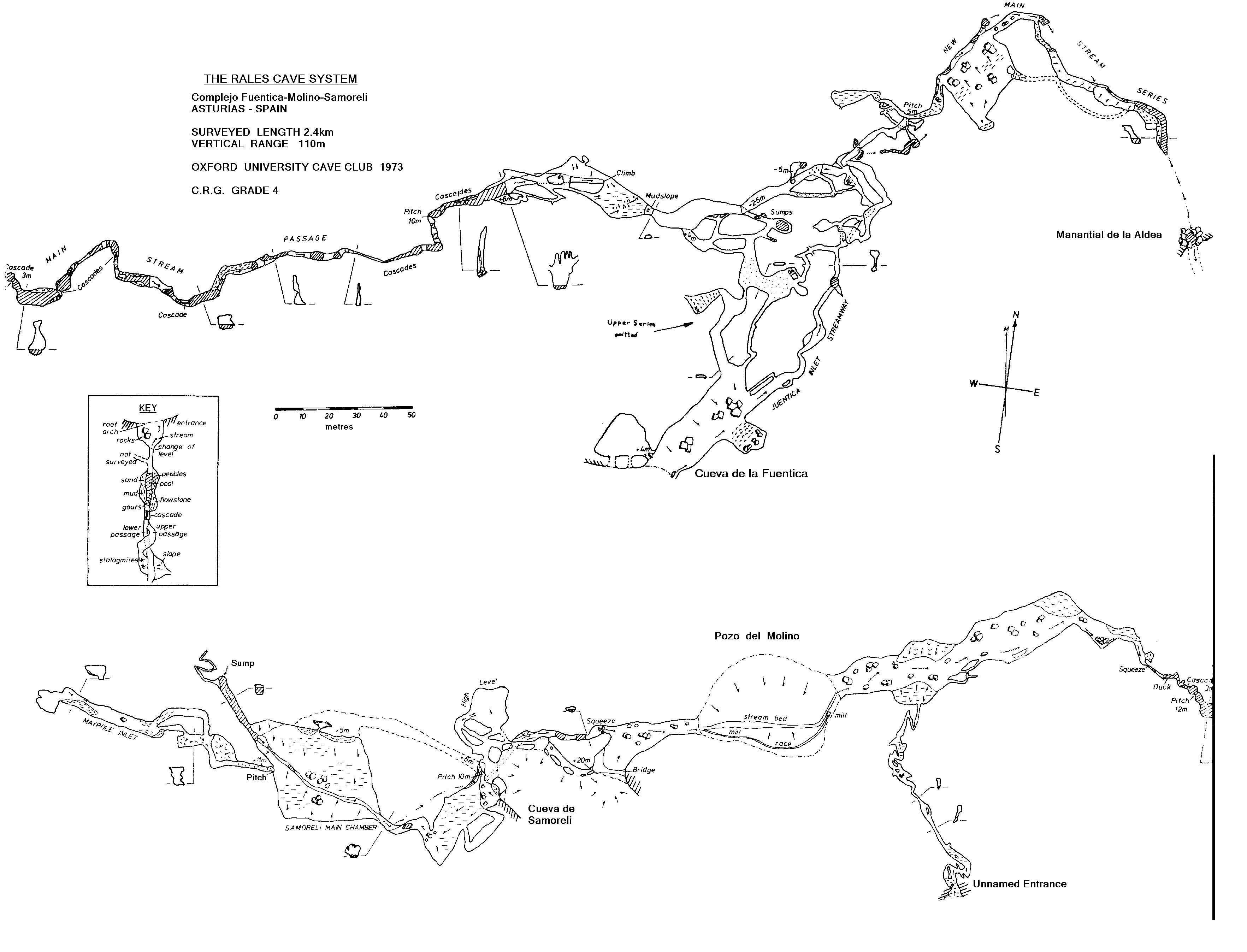
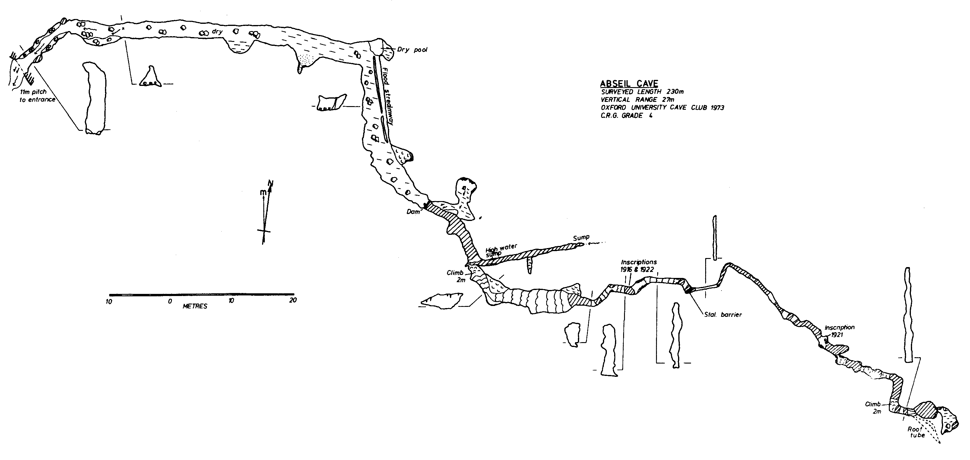
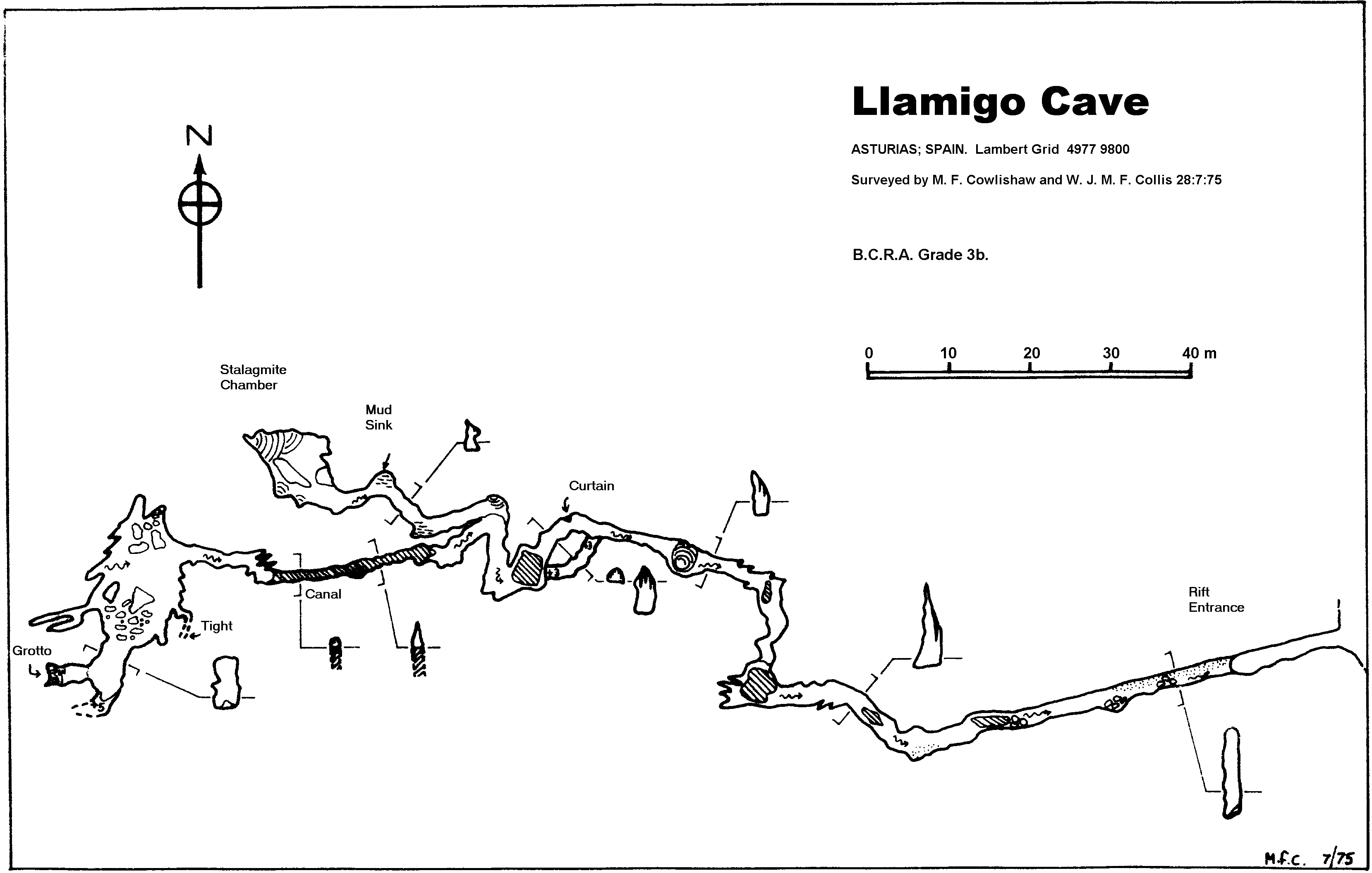
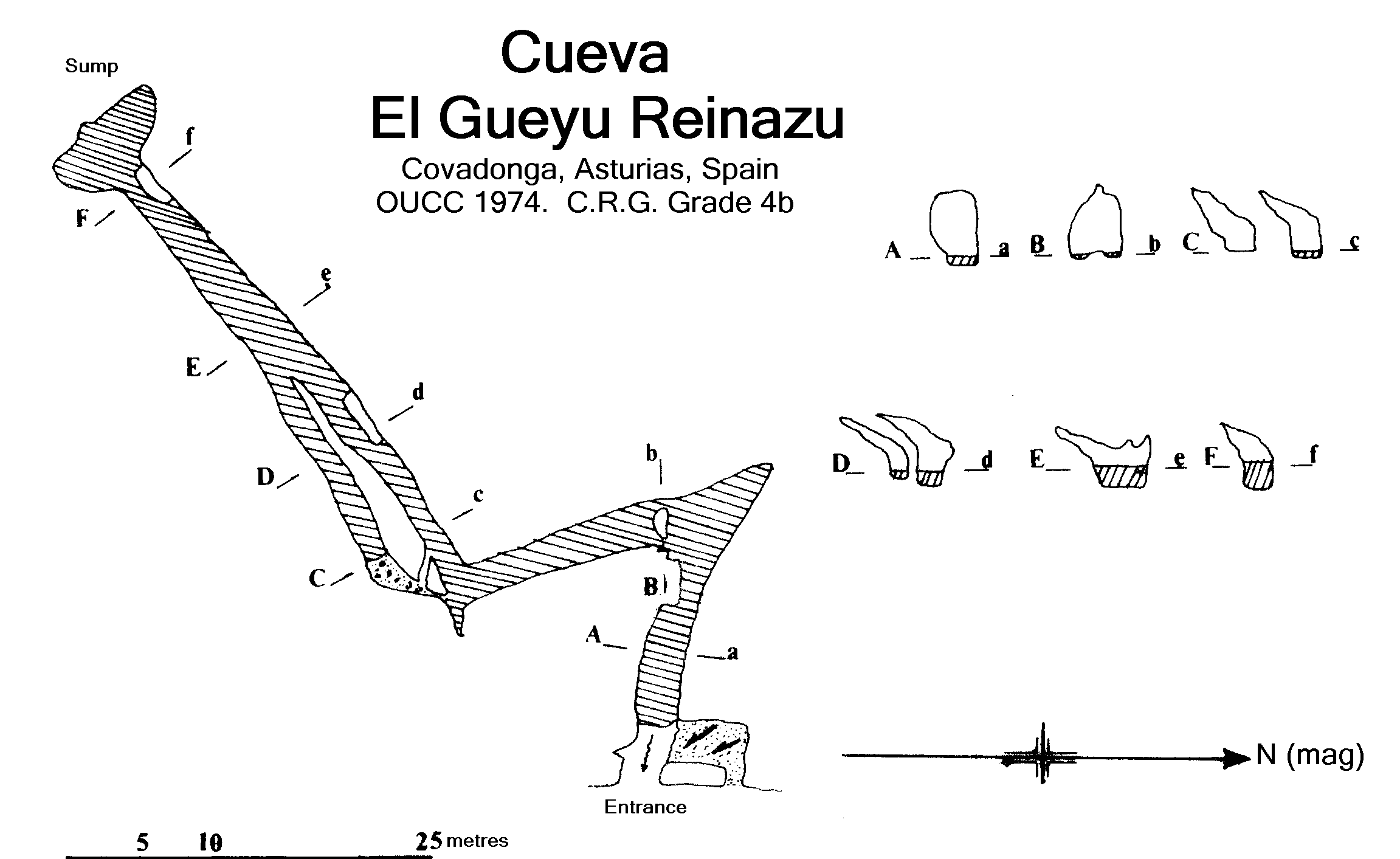
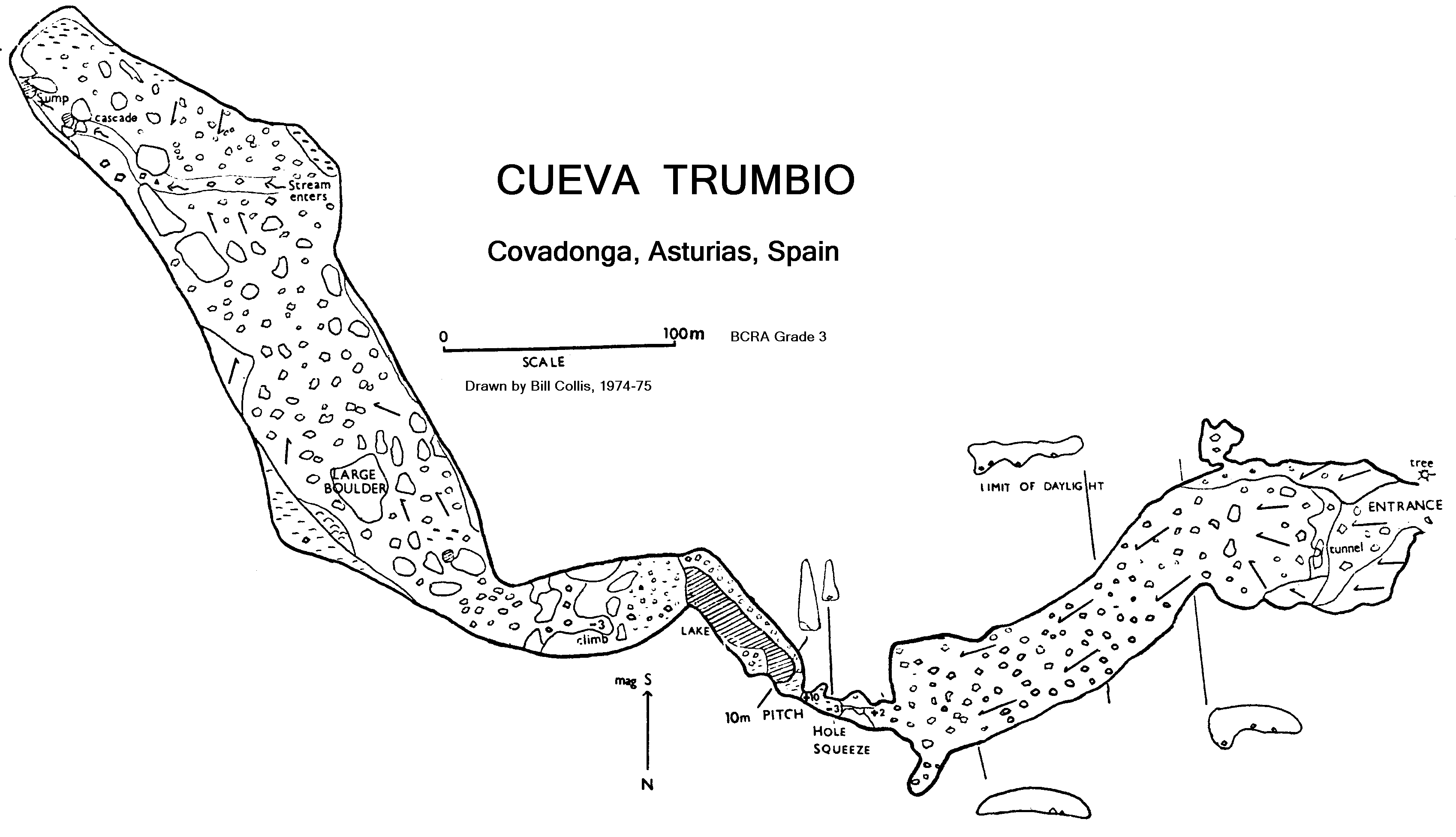